The Territorial Formation of Brazil: From Continental Archipelago to National Unity
Historical maps and the formation of Brazil
Historical Maps show the development and territorial expansion of Brazil and the Western Hemisphere from Discovery to Independence.
Learn about the historical facts that led to Brazil’s emergence from a continental archipelago.
Map of the Western Hemisphere, 1550
The beginning of Portuguese colonisation
When Pedro Álvares Cabral landed on the coast of what was to become Brazil on 22 April 1500, his aim was not to conquer new lands – the focus of the Portuguese Crown was to control the eastern spice route.
Consolidating the Portuguese presence required the threat of European rivals, notably the French, who established trading posts and alliances with the indigenous peoples.
Map of Brazil divided into fourteen captaincies, 1657
This rivalry led the Crown to adopt a policy of systematic colonisation, resulting in the creation of the hereditary captaincies in 1532.Map of Brazil divided into fourteen captaincies, 1657
Captaincies and territorial defence
By granting large parts of the colony to Portuguese nobles, the king hoped to confirm his sovereignty until 1559 over the main coastal settlements between Itamaracá and São Vicente.
In this context, the colonisation attempts of France and Holland, which later turned their attention to the Antilles, caused a crisis in the Brazilian sugar economy.
France, Holland and England were content with the Guianas, and so it was through the disinterest of its rivals rather than through any force of its own that Portugal consolidated a continental empire.
Mapa do hemisfério ocidental de 1700
The Bandeiras and inland expansion
One of the most remarkable periods in colonial history was that of the Bandeiras – expeditions launched from São Paulo, with the tacit support of the crown, that extended Portuguese rule into the interior.
These expeditions, made up of whites, mestizos and allied Indians, mainly followed the tributaries of the Paraná River and covered thousands of kilometres.
The aims of the Bandeiras
To capture the natives to work on the sugar cane plantations along the coast.
Conflicts with the Jesuits, especially the Spaniards, whose Native missions were often targeted.
Later, the search for precious metals led to the discovery of gold in Minas Gerais (late 17th century), Goiás (1718) and Mato Grosso (1725).
As well as profit, there was also a lust for war and exploration, which led the Paulistas to take part in conflicts such as battles against indigenous peoples and the war against the Dutch.
Map of Brazil 1747 – copper engraved map with good detail along the coast with dozens of place names. The map covers the region between northern Paraguay and north to the mouth of the Amazon. A large inset of St Catherine’s Island fills the empty ocean. In a long note at the end, Bowen states that he has deliberately “omitted the imaginary Island of Ascension, under the authority of Dr Halley”. The map contains several other annotations, including an area claimed to be “rich in gold and silver”. “A New & Accurate Map of Brazil. Divided into its capitals, drawn from the most approved modern maps & charts…”, Bowen, Emanuel
Brazil’s unity and the role of Napoleon
Despite its continental size, Brazil maintained political unity after its independence in 1822. This was partly due to Dom João VI‘s decision to bring the Portuguese Court to Brazil while fleeing from Napoleon Bonaparte.
As the Spanish Empire disintegrated, the Portuguese Empire was concentrated in Brazil, providing an institutional continuity that prevented it from fragmenting into several republics, as happened in Spanish America.
The “slave solder” and the consolidation of unity
The preservation of slavery was one of the reasons for unity: the regional oligarchies could not maintain this system alone. Imperial power guaranteed both diplomatic coherence with England and military strength against separatist and abolitionist movements.
Brazil as an economic archipelago
Despite its political unity, Brazil has functioned for centuries as a true economic archipelago, as Celso Furtado has shown. Its history is marked by regional economic cycles that have shaped the territory:
Sugar (17th century) – North-east
Gold (late 17th and early 18th centuries) – Minas Gerais
Coffee (19th and 20th centuries) – Southeast
Rubber (early 20th century) – Amazon
Every cycle:
Populated new regions
Created different social and economic relations.
It led to the formation of autonomous zones which concentrated on exports.
These regions communicated only through cabotage. Proof of this was World War II, when a few German submarines were enough to disrupt the connection between the north and south of Brazil, due to the lack of internal infrastructure..
Other territorial factors
In addition to economic cycles, other factors were involved in the territorial formation of Brazil:
The dynamism of the bandeirantes.
The work of the missionaries.
The expansion of the pastoralists.
The political and administrative will of the Crown.
The economic foundations: 16th and 17th centuries
The first consolidated economic base was sugar production, made possible by the favourable climate and soil of the north-east. This rare and light product was in high international demand and maintained territorial occupation.
Consequences of the sugar cycle
Importation of enslaved Africans: began in 1532 and continued until the 19th century, displacing millions of people from regions such as Guinea, Angola and Mozambique.
Tobacco Cycle: The Recôncavo Baiano specialised in this production, which was used as currency by the enslaved.
Food and livestock production: Subsistence farming developed in the agreste. In the semi-arid Sertão, animal husbandry developed, especially along the São Francisco River.
Video on the development and territorial expansion of Brazil
Evolução e a expansão territorial do Brasil
Historical maps showing the territorial development of the Western Hemisphere and Brazil from 1550 to 1888
Map of the Western Hemisphere, 1550 – Sebastian Munster (1489 – 1552) was one of the three most famous cartographers of the 16th century, along with Mercator and Ortelius. Munster’s Geographia and Cosmographia Universalis were two of the most widely read and influential books of the time. His editions of Ptolemy’s Geographia, published between 1540 and 1552, were illustrated with 48 woodcut maps, the standard 27 Ptolemaic maps supplemented by 21 new maps. These new maps included a separate map of each of the known continents and marked the development of regional cartography in central Europe. The Ancient Geography was a prelude to Münster’s major work, the Cosmographia, which was published in six languages in nearly 30 editions between 1544 and 1578, and then revised and re-edited by Sebastian Petri between 1588 and 1628. The Cosmographia was a geographical reference as well as a historical and ethnographic description of the world. It included the maps of the Geographia, plus additional regional maps and city views, with nearly 500 illustrations, making it one of the most popular pictorial encyclopaedias of the 16th century. This map of the New World is often credited with popularising the name America due to the popularity of Munster’s Cosmographia and the numerous editions published in the 16th century. The influence of Marco Polo’s explorations of Asia in the 13th century is evident in the 7,448 islands of the North Pacific and Zipangri (Japan) shown off the west coast of North America. The North American continent has a very strange shape, with no Californian land mass and the eastern region almost split by a body of water known as the Verrazzano Sea. Yucatan is still shown as an island, Cozumel is called Cozumela, and Lake Temistitan (unnamed in the state) is connected to the Gulf of Mexico. South America has a large bulge on the west coast, the Amazon River is very short, and cannibals inhabit the continent, shown as Canibali next to a gruesome vignette of human limbs. The map is very decorative, with Magellan’s surviving ship Victoria appearing in the Pacific. The flags of Spain and Portugal represent their respective spheres of influence in the New World. This is the 5th state by Burden and the 4th state by Kershaw, with place names Temistitan in Mexico and Insula Atlantica in South America.Map of Brazil 1554 – This fascinating pictorial map is one of the first regional maps of Brazil available. Illustrated with north to the right, the map is filled with vignettes depicting native life rather than focusing on geographical information. Indians are shown with bows and arrows, axes, llamas and hammocks, for which Brazilians are well known. The surrounding ocean is filled with French and Portuguese ships and sea monsters. Along the coast, Europeans are shown interacting with the natives. The limited geographical information is rather inaccurate. The Amazon River (here called the Maranon F.) and the Paraná River originate from lakes near an erupting volcano. Mountains and false rivers fill the western part of Brazil, labelled Terra non Descobrirta (undiscovered land). This woodcut map is from the first block published in 1554, which was destroyed by a fire in 1557 at the printing works of Thomaso Guinti. A second block was cut in 1565, with the notable difference that Descoperta is written at the top centre instead of Discoperta. The second block was used again in 1606 and can be distinguished from the previous print by the appearance of woodworm damage on the block. Many of the blocks in the 1554 edition of Ramusio’s Delle Navigationi Et Viaggi were made by the great Venetian cartographer Giacomo Gastaldi. “Brazil, Ramusio, Giovanni Battista.Map of the Western Hemisphere, 1581 – This is one of the most famous maps of the Americas and had a major influence on future cartography of the New World. The map is largely based on Gerard Mercator’s large multi-sheet world map of 1569. The most recognisable features of the map are the bulbous Chilean coastline and the exaggerated width of the North American continent. In North America, the long St Lawrence River crosses the continent to almost meet the fictitious Tiguas River flowing to the west. The strategically placed title cartouche hides the unknown South Pacific and thus most of the supposed great southern continent, which is shown attached to New Guinea and Tierra del Fuego. This map is from the second copper plate containing the same geography as the first [1570]. On this plate, the largest ship in the Pacific is now sailing east and away from the viewer. Religious persecution forced Ortelius to leave Antwerp and there was a four-year hiatus in the publication of the Theatrum. When he re-established himself in Liège, he used Christopher Plantin’s large printing press to resume publication with several revised plates. This plate had a relatively short life of only 8 years, being replaced in 1587 by the easily distinguishable plate of the revised South American form.Map of the Western Hemisphere, 1587 – This is one of the most famous maps of the Americas and had a huge influence on future cartography of the New World. Engraved by Frans Hogenberg, it is largely based on Gerard Mercator’s great multi-sheet world map of 1569. The map shows an exaggerated extension of the North American continent, with the long St Lawrence River crossing the continent to almost meet the fictitious Tiguas River flowing westwards. The strategically placed title card hides the unknown South Pacific and thus most of the supposed great southern continent, which is shown attached to New Guinea and Tierra del Fuego. This is the third plate of the Americas used by Ortelius, as evidenced by the removal of the bulge on the south-west coast of South America and the addition of a cartouche in North America. Also on this plate, the Solomon Islands are mentioned for the first time since their discovery in 1568, and the names California, R. de los estrechos and C. Mendocino are added to the west coast of North America. The native name Wingandekoa was added to the east coast, the result of an unsuccessful attempt by the English to colonise the Outer Banks – “Americae sive Novi Orbis, Nova Descriptio”, Ortelius, Abraham.Map of the Western Hemisphere, 1592 – This engraving is part of a remarkable series of publications illustrating voyages of discovery and exploration in various parts of the world. The project was begun by Theodore de Bry of Frankfurt in 1590 and continued for another 54 years. Together they became known as the Grands Voyages (to America and the West Indies) and the Petits Voyages (to the Orient and the East Indies). De Bry died after completing the first six parts of the Grands Voyages. The project was completed first by his widow and two sons, Johann Theodore de Bry and Johann Israel de Bry, and then by his son-in-law, Matthaus Merian, in 1644. Focusing on the Spanish possessions in the Americas, this map covers what is now the southern United States down to South America. It was published to accompany the accounts of the voyages of Johann van Stadden and Jean de Lery. The cartography is taken from de Bry’s own map of Florida and the West Indies after Jacques le Moyne. However, there is no obvious source for the cartography of South America, the southern regions of which are shown very wide, but not as bulging as in Ortelius’ version. De Bry’s extraordinary engraving skills and artistic style are evident in the large, elaborate cartouches, coats of arms, two wind roses, sea monsters, a Spanish galleon and the intricate border.Map of the Western Hemisphere, 1609 – Jodocus Hondius’ map of America is one of the most elaborate examples of fine Dutch cartography. The decorations, including sea monsters, native birds, native canoes and sailing ships, were taken from De Bry’s Grand Voyages. Particularly noteworthy is the scene of the natives preparing an intoxicating drink made from cassava roots, inspired by Hans Staden’s harrowing adventure in Brazil. The continents are shown in a stereographic projection, which became increasingly popular in the early 17th century. It shows a more accurate western coastline of South America and reduces the width of Mexico. However, North America is still very wide and Virginia has an exaggerated coastline. Newfoundland is based on Plancius. The coastline is fully engraved with place names.Map of South America, 1615 – Excellent folio map of the continent, added by Jodocus Hondius for publication in his sequel to the Mercator Atlas. The interior shows the great mythical Parime Lacus straddling the equator and an equally interesting river system. The great Rio de la Plata flows south from the supposed Eupana Lacus in Brazil, while the R. Grande flows north from the same lake to join the Amazon. The Strait of Magellan is shown, but Tierra del Fuego is part of the great southern continent. The map is beautifully engraved with a pattern of waves on the oceans, full of ships, sea monsters and a native canoe. The continent is flanked by two elaborate cartouches; the title to the right and a large internal plan of Cuzco, which is incorporated into the distance scale cartouche to the left. In the centre is an Indian with bow and arrow. “America Meridionalis, Hondius, Jodocus.Map of South America, 1619 – Excellent folio map of the continent, added by Jodocus Hondius for publication in his sequel to the Mercator Atlas. The interior shows the great mythical Parime Lacus straddling the equator and an equally interesting river system. The great Rio de la Plata flows south from the supposed Eupana Lacus in Brazil, while the R. Grande flows north from the same lake to join the Amazon. The Strait of Magellan is shown, but Tierra del Fuego is part of the great southern continent. The map is beautifully engraved with a pattern of waves on the oceans, full of ships, sea monsters and a native canoe. The continent is flanked by two elaborate cartouches; the title to the right and a large internal plan of Cuzco, which is incorporated into the distance scale cartouche to the left. In the centre is an Indian with bow and arrow. “America Meridionalis, Hondius, Jodocus.Map of the Western Hemisphere, 1623 – Jodocus Hondius’ map of America is one of the most elaborate examples of fine Dutch cartography. The decorations, including sea monsters, native birds, native canoes and sailing ships, were taken from De Bry’s Grand Voyages. Particularly noteworthy is the scene of the natives preparing an intoxicating drink made from cassava roots, inspired by Hans Staden’s harrowing adventure in Brazil. The continents are shown in a stereographic projection, which became increasingly popular in the early 17th century. It shows a more accurate western coastline of South America and reduces the width of Mexico. However, North America is still very wide and Virginia has an exaggerated coastline. Newfoundland is based on Plancius. The coastline is fully engraved with place names.Map of the Western Hemisphere, 1628 – Jodocus Hondius’ map of America is one of the most elaborate examples of fine Dutch cartography. The decorations, including sea monsters, native birds, native canoes and sailing ships, were taken from De Bry’s Grand Voyages. Particularly noteworthy is the scene of the natives preparing an intoxicating drink made from cassava roots, inspired by Hans Staden’s harrowing adventure in Brazil. The continents are shown in a stereographic projection, which became increasingly popular in the early 17th century. It shows a more accurate western coastline of South America and reduces the width of Mexico. However, North America is still very wide and Virginia has an exaggerated coastline. Newfoundland is based on Plancius. The coasts are fully engraved with place names. This is from the latest French edition of this important atlas.Map of the Western Hemisphere, 1628 – Jodocus Hondius’ map of America is one of the most elaborate examples of fine Dutch cartography. The decorations, including sea monsters, native birds, native canoes and sailing ships, were taken from De Bry’s Grand Voyages. Particularly noteworthy is the scene of the natives preparing an intoxicating drink made from manioc roots, derived from Hans Staden’s harrowing adventure in Brazil. The continents are shown in a stereographic projection, which became increasingly popular in the early 17th century. It shows a more accurate western coastline of South America and reduces the width of Mexico. However, North America is still very wide and Virginia has an exaggerated coastline. Newfoundland is based on Plancius. The coasts are fully engraved with place names. This is from the latest French edition of this important atlas.Mapa do Hemisfério Ocidental de 1631 – Esta é a versão incomum e maior do mapa das Américas de Merian. O estilo ousado de gravação de Merian copia a cartografia do mapa de Jodocus Hondius de 1631. A América do Norte é retratada com uma proeminente Virgínia e uma estranha costa da Nova Inglaterra. A costa oeste acima da Califórnia torna o continente muito largo e há apenas uma sugestão dos Grandes Lagos. Há um grande lago interior na América do Sul equatorial. Inserções das Regiões Polares são definidas em cartelas de cintas. O mapa é finamente decorado com uma cartela de título com crânios e ossos humanos, representando o lendário canibalismo das Américas, e os mares estão repletos de navios, batalhas navais e ferozes monstros marinhos.Map of the Western Hemisphere, 1643 – This impressive carte-a-figure map is an excellent example of the fine art of decorative cartography and a 17th century European view of the New World. The coastal contours generally follow Ortelius and Wytfliet, with the nomenclature of various explorers and settlers. The side panels, each with five portraits of indigenous people, are taken from John White (Virginia), Hans Staden (Brazil) and other accounts of early explorers. At the top are nine town plans, including Havana, St Domingo, Cartagena, Mexico City, Cusco, Potosi, I. la Mocha in Chile, Rio de Janeiro and Olinda in Brazil. This is one of the few maps of the Americas by this famous Dutch cartographer. The map itself is similar to Blaeu’s wall map of 1608 with Henry Hudson’s additional discoveries of North America and Tierra del Fuego with the Strait of Le Maire. This is the fourth state of the plate with the print changed to Auct: Guiljelmo Blaeuw and some re-engravings of the sea around the ships and sea patterns.Map of Cabo Santo Agostinho from 1645 – This beautiful copper engraved map shows the harbour and fortifications of Cabo Santo Agostinho. Fort Nazaré is shown on a hill on the right. Decorated with a compass pointing north at the top right of the map and a title cartouche in stripes. “Afbeeldinghe van de Cabo St. Augustin ende Forten”, by Laet, Joannes.Map of Brazil from 1652 – Beautiful depiction of Brazil with the north oriented to the right by a beautiful compass rose. The map is inset with two regions of Dutch interest in the area; Baja de Todos los Sanctos and Pernambuco. The interior is devoid of geographical information, except for largely imaginary rivers and forests. Instead, the region is full of dramatic scenes of native peoples, including warfare and cannibalism, and some curious wildlife. The hereditary captainships established by the Portuguese are marked along the coast. The decorative title cartouche is flanked by a local family and the seas are decorated with sailing ships, a sea monster and a compass rose. French text on verso, published between 1652-58. “Accuratissima Brasiliae Tabula”, Hondius/Jansson.Map of Brazil divided into fourteen captaincies, 1657 – Map of Brazil divided into fourteen hereditary captaincies, 1657 – This is a reduced version of Sanson’s important map showing the Portuguese possessions in Brazil. The coastal regions were divided by the Portuguese Crown into fourteen captaincies, or hereditary ports. The holders of these grants, called donatários, were responsible for their defence and development. A series of rivers appear in the interior. The mythical Lago de los Xarayes appears on the left, and the unknown interior is conveniently covered by the garlanded title cartouche. Sanson’s small maps of his America in various maps…, first published in 1656 and engraved by A. Peyrounin, were copied several times by various map publishers. Johann David Zunners made copies of Sanson’s maps for his German translation of Die Gantze Erd-Kugel in 1679. Johannes Ribbius and Simon de Vries published copies in 1682 and 1683, with new maps engraved by Antoine d’Winter. The plates were later sold to François Halma, who used them in 1699 and again in 1705, with the titles again engraved in Dutch. The titles on the d’Winter plates were again engraved in French and then used by Nicholas Chemereau in 1715 and Henri du Sauzet in 1738. “Le Bresil, dont la Coste est Possedee par les Portugais, et Divisee en Quatorze Capitaineries…”, Sanson, Nicolas.Map of the Western Hemisphere of 1659 – This is a very rare derivative of the important Hondius map of 1618. The engraver is unknown, although it is a close copy of Picart’s 1644 version, which in turn was derived from Jansson’s 1623 map. North America retains the peninsula of California, and there isn’t much detail along the east coast in the mid-Atlantic region. In the south-west, the famous Seven Cities of Cibola appear on the shores of a large false lake. In South America, the mythical Parime Lacus is shown south of Guyana, and there are two engraved scenes, one showing a cannibal feast and the other a mythical giant from Patagonia. Two stylised insets of the polar regions are placed on strip maps; the North Pole shows Frobisher’s theory of the Northwest Passage, and the South Pole shows the long-held idea of the mythical southern continent. The map is flanked on three sides by carte-a-figure borders depicting Native Americans and their major cities. This map is easily distinguished from Hondius’s map by the fact that the figures on the sides were inverted when copied by the engraver. Unlike Blaeu’s similar map, the towns at the top include three North American towns: the Indian village of Pomeiooc in Virginia, the French fort in Carolina, and St Augustine in Florida.1660 Map of the Western Hemisphere – An unusual and splendidly figured map of the Americas. The map combines many different sources, including Luke Foxe’s model of the island of California. The only reference to the Great Lakes is a small L at the end of the St Lawrence River. Nieu Neder Land occupies the east coast, and there is no mention of any English settlement other than the name Virginia. In South America, a large river and lake system borders Brazil, with the mythical Lake Eupana Lacus. A second mythical lake, Parime Lacus, is shown along the equator. The decoration is taken from van den Keere’s map of 1614. The figures on the sides depict the natives of Virginia, Magellan and Brazil, and the cities at the top include Cusco, Mexico, Olinda, Havana, St Dominique and Cartagena. The map is further embellished with a title card showing a native Indian riding an armadillo and Neptune frolicking in the Pacific with mermaids and seahorses. This is the first state of this map to be issued separately, with the date in the title.Map of South America and Brazil, 1624 – This engraving is part of a remarkable series of publications illustrating voyages of discovery and exploration in various parts of the world. The project was begun by Theodore de Bry of Frankfurt in 1590 and continued for another 54 years. Together they became known as the Grands Voyages (to America and the West Indies) and the Petits Voyages (to the Orient and the East Indies). De Bry died after completing the first six parts of the Grands Voyages. The project was completed first by his widow and two sons, Johann Theodore de Bry and Johann Israel de Bry, and then by his son-in-law, Matthaus Merian, in 1644.Map of Brazil, 1630 – This beautiful map was a collaboration between Hessel Gerritsz, official cartographer of the Dutch East India Company, and Johannes de Laet, director of the newly formed Dutch West India Company. Their maps of South America laid the foundations for many other cartographers. The detail is limited to the coasts and includes the capitanias. The interior is filled with a large title cartouche and distance scales, and the map is further embellished by a compass rose pointing north to the right of the map. “Provincia de Brasil cum Adiacentibus Provinciis”, Gerritsz/De Laet.Map of South America, 1638 – This is an important decorative map of the continent and an essential piece for any South American collection. The coastlines are well detailed, but the interior is full of inaccuracies. Several rivers (including the Amazon and the Paraguay) flow into the Lago de los Xarayes. The mythical Parime Lacus dominates the interior of Guyana. The map is richly decorated with ships and sea monsters in the oceans and vignettes of villages and animals on the continent. The large title cartouche shows native peoples and animals. “Americae Pars Meridionalis”, Hondius, Henricus.Map of Olinda in Pernambuco 1640 – This map shows two views of the Portuguese sugar colony in Brazil during the Dutch invasion in 1630. The top view shows the Dutch fleet attacking the harbour and fort. Below is a plan of the town of Olinda and its surroundings, with an interior view of a sugar mill. Both visualisations contain decorative cartouches with keys to important places. “Olinda de Phernambuco”, Jansson, Jan.Map of the Bay of All Saints 1644 – This rare map of Salvador and the Bay of All Saints shows the Dutch attack and capture of the city of Salvador in May 1624. Salvador, then the capital of Brazil, was a strategic port under Portuguese control. The Dutch, determined to take control of Brazil, formed the West India Company in 1621 and sent a large expedition to Brazil. On 8 May 1624, the Dutch fleet under the command of Admiral Jacob Willekens and Vice-Admiral Pieter Heyn arrived in Salvador and attacked the city. The Dutch managed to take the city, although the Portuguese regained control less than a year later. This map shows the city of Salvador and its fortifications, with the Dutch ships approaching the city. The rest of the coast is sparsely engraved with a few small towns, churches and settlements. The map is oriented with north to the left and has a nice strip chart that incorporates the distance scale. Published in De Laet’s account of the history of the Dutch West India Company from its beginnings to 1636. “Baya de Todos os Sanctos”, de Laet, Joannes.Map of the East Coast of Brazil, 1647 – This beautiful map of the Brazilian coast is decorated with a huge garland of native fruits and a jaguar, tapir and capybara at the top. With north oriented to the right, the map covers the coastal region from São Francisco south to the mouth of the Vaza-Barris River. The map follows the rivers inland, with place names and topographical details along their banks. There is a naval skirmish, three Dutch ships and a canoe on the Atlantic coast. Based on real surveys by Georg Marcgraf, Elias Herckmanns and others, it was one of the first maps of Brazil based on non-Portuguese data. Blaeu first published this and its supplementary maps in 1647 for Gaspar Barleus’ Rerum per octennium in Brasília. They were also compiled into a large wall map, Brasília qua parte paret Belgis. The maps then appeared in the Atlas Maior of 1662. “Praefectura de Ciriii, vel Seregirppe Delrey cum Itapuama”, Blaeu, Johannes.Map of South America, 1650 – This attractive map shows the continent with Sanson’s characteristic attention to detail. The relatively unknown Amazon region is given short shrift. The mythical Lac de Parime still appears, with the legendary Manoa del Dora (City of Gold) on its western shore, although the size of the lake has been reduced from earlier depictions. There is considerable detail of towns and cities, and the captaincies of Brazil are outlined. Decorated with a strapwork title cartouche. Engraved by A. Peyrounin. “Amerique Meridionale”, Sanson/Mariette.Map of Paraíba from 1662 – Excellent map of the Brazilian coast, including the captaincies of Paraíba and Rio Grande. The map was drawn after real research by Georg Markgraf, Elias Herckmanns and others and was one of the first maps of Brazil based on non-Portuguese data. The map is richly engraved with a large scene of a procession of Tupinambás Indians carrying a Dutch flag, part of a sugar mill and three major naval battles depicted at sea. It is also decorated with coats of arms, a compass rose and a title cartouche in stripes. The series of maps of the captaincies of Brazil is unlike any other map in Blaeu’s atlases. Blaeu first published these and the supplementary maps for Gaspar Barleus’ Rerum per octennium in Brasília in 1647. They were also assembled into a large wall map, Brasília qua parte paret Belgis; the places where the sheets overlapped are marked by faint lines on the left. The maps then appeared in the Atlas Maior of 1662. “Praefecturae de Paraiba, et Rio Grande”, Blaeu, Johannes.Map of Eastern Brazil 1664 – This beautiful map of the Brazilian coast is richly decorated with a scene of natives with a watchtower and a huge fleet of ships. With north to the right, the map covers the coastal region from São Francisco to Recife. It was based on real surveys by Georg Marcgraf, Elias Herckmanns and others and was one of the first maps of Brazil based on non-Portuguese data. Blaeu first published this and his supplementary maps for Gaspar Barleus’ Rerum per octennium in Brasília in 1647. They were also compiled into a large wall map, Brasília qua parte paret Belgis. The maps then appeared in the Atlas Maior of 1662. This example is the second state with the addition of a native in the watchtower. “Praefecturae Paranambucae Pars Meridionalis”, Blaeu, Johannes.Map of Brazil, 1671 – This magnificent map of Brazil, including parts of neighbouring countries, was one of 23 maps in this rare account of the Luso-Dutch colonial war. Written by João José de Santa Teresa, known to bibliophiles as Saint Teresa, it is considered one of the most sumptuous 17th-century works on Brazil. Saint Teresa, a Portuguese Carmelite, spent twelve years in the Jesuit missions of South America before returning to Europe to become librarian of the Jesuit College in Rome. His account was heavily subsidised by Pedro II of Portugal and some of the leading artists and engravers of the time, including Antonio Horacio Andreas, were commissioned to work on the project. It was published by Giacomo Giovanni Rossi. The map itself is beautifully drawn and provides excellent detail of the coastlines of Brazil, Argentina, Uruguay, French Guiana, Suriname and Guyana from the Rio de la Plata in the south to beyond the mouth of the Amazon River in the north. Although little was known about the interior of Brazil at the time, it is full of mountains, rivers and the fictional Port of Kings in Brazil and Lake Parime in Guyana. A large compass rose orients the map, with north on the right. The map is lavishly decorated with two cartouches, a vignette of cannibalism and an allegorical scene with the Brazilian royal coat of arms at the top, with two putti holding chains with Hippolyta, Queen of the Amazons, and Medusa. “Il Regno del Brasile Parte Nobilissima del Mondo Nuovo…”, St. Teresa, J. J.1677 Map of the Western Hemisphere – Visscher’s map greatly influenced the cartography of the Americas, both geographically and artistically. One of the most striking geographical details copied by other cartographers is the large open lake in the Great Lakes region. In fact, Visscher copied this from Blaeu’s wall map mundi [1648], but popularised it on this map. California is shown as an island, as in the Briggs model, but with a wider north coast. The map is decorated with two large cartouches that were copied by other cartographers. The upper cartouche is dedicated to Cornelius Witsen and shows angels fighting a demon for the soul of an Indian. The pictorial title cartouche shows scenes of gold mining, hunting and a native chief under an umbrella. This is the second state with the addition of Vischer’s privilege.Mapa do Litoral do Brasil of 1678 – This magnificent map of Brazil is mainly a nautical chart with details limited to the coastline. It covers the Brazilian coast from the mouth of the Amazon to the Rio de la Plata, where Argentina now lies, with north oriented to the left by two beautiful compass points. A dramatic title cartouche filling the interior is composed of a montage of scenes showing Portuguese and Dutch explorers and missionaries, a native ceremony, mining, exotic animals and products, etc. Directional lines cross the entire map, which is further embellished by four sailing ships. “Littora Brasiliae / Pascaert van Brasil”, Wit, Frederick de.Map of Recife in Pernambuco from 1679 – Brazil – Rare aerial map of the city of Recife and its surroundings with the Dutch fortifications highlighted. Although originally founded by the Portuguese, the Dutch decided to invade several towns in Pernambuco because of the local sugar cane industry. From 1630 to 1654, the Dutch controlled the city of Recife, which became the new capital of Dutch Brazil, the city of Mauritsstad. Mauritsstad (here called Mauritiopolis) became one of the most cosmopolitan cities in the world under Dutch rule and is known for being home to the first Jewish community and synagogue, botanical garden and zoo in the Americas. “Mauritiopolis Reciffa, et Circumiacentia Castra”, Merian, Matthaus.Map of the Brazilian Coast from Rio Paraíba to Cabo de Santo Agostinho from 1683 – This rare and classic sea chart covers the Brazilian coast from Rio Paraíba to Cabo S. Augustino. Augustino. It is filled with lines of loxodromia and decorated with a sailing ship. Off the coast, the water is full of soundings. Natives flank the title cartouche and tritons surround the distance scales. North is to the right. “Pas-Kaart, van de Zee-Kusten, van, Brazilia, Tusschen, Punto de Lucena en Cabo S. Augustino”, Keulen, Johannes van.Engraving of the Bay of All Saints from 1690 – Engraving of the Bay of All Saints from 1690 – Beautiful copper engraving showing the Dutch fleet capturing the fort at the entrance to the Bay of All Saints in north-east Brazil. The scene is very active with waving cannons and small figures rushing into action. A close-up of the bay is depicted on a scroll above the scene. “T’Neemen van de Suyker Prysen inde Bay de Tode los Santos Anno 1627”, Leti, Gregorio.Engraving Forte dos Reis Magos 1690 – Natal – An aerial view of the fort (now Natal) at the mouth of the river Potengi, showing the Dutch invasion and capture of the Portuguese fort in 1633. The harbour is full of ships and armies are shown rushing to defend the fort. “Veroveringe van Rio Grande in Brasil. Anno 1633”, Leti, Gregorio.Map of Paraíba, 1690 – This panoramic map shows the region of Paraíba and the Portuguese fortifications at the mouth of the Paraíba River. The scene of the Dutch attack on the region is illustrated with the Dutch fleet and the defence of the Portuguese armies. “Afbeeldinghe van Pariba ende Forten”, Leti, Gregorio.1690 Map of Cabo de Santo Agostinho in Pernambuco – This beautiful panoramic view shows the Dutch fleet and the fortresses of Cabo Santo Agostinho. The strapwork title cartouche contains a numbered key identifying four locations. – “Afbeeldinge vande Cabo St. Augustin met Haer Forten”, Leti, Gregorio.Map of Brazil of 1695 – This rare and beautiful map is Johannes Blaeu’s third map of Brazil. Designed by Joannes de Broen and engraved by Abraham Wolfgang, it was completed just before the great fire that destroyed the printing house and was therefore never included in Blaeu’s atlases. In 1694 Pieter Schenk bought several copper plates from Blaeu, including this one. The map shows the captaincies along the coast and is a significant improvement on Blaeu’s previous maps of Brazil. The beautiful cartouche is surrounded by cherubs and a river god, and Schenk’s signature appears below the title. “Nova et Accurata Brasiliae totius Tabula”, Blaeu/Schenk.Map of South America, 1694 – This beautiful map of the continent is decorated with elaborate title and mileage cartouches, balancing the lower part of the map with images of Native Americans, flora and fauna. One cartouche contains the title of the map, while the other shows eight different distance scales, recording the variety of European measurement systems before the metric system was adopted during the French Revolution. Cartographically, the map shows the course of the Amazon fairly accurately, but the source of the river is a fascinating labyrinth of intertwined waterways. The fictitious Mer de Parime is named in Guyana, along with the mythical Manoa el Dorado on its banks. In addition, the Paraguay River erroneously flows into a lake called Xarayes in the middle of Brazil. An alternative Latin title appears above the map: “America Meridionalis in suas Praecipuas Partes Accurate Divisa, ad usum Serenissimi Burgundiae Ducis”. “L’Amerique Meridionale Divisee en ses Principales Parties”, Jaillot, Alexis-Hubert.Map of the Captaincy of Espirito Santo and Porto Seguro, 1698 – This impressive map covers the coast from Rio de Janeiro to about Ilhéus. It was one of 23 maps in this rare account of the Dutch-Portuguese colonial war. Written by João José de Santa Teresa and known to bibliophiles as the Santa Teresa, it is considered one of the most sumptuous works of the 17th century in Brazil, partly because of its incredible maps. St Teresa, a Portuguese Carmelite, spent twelve years in the Jesuit missions of South America before returning to Europe to become librarian of the Jesuit College in Rome. His account was heavily subsidised by Pedro II of Portugal and some of the leading artists and engravers of the time, including Antonio Horacio Andreas, were commissioned to work on the project. It was published by Giacomo Giovanni Rossi. The map itself is beautifully drawn and gives an excellent view of the region, with carefully delineated bays, rivers and streams. Even navigational hazards along the coast are shown. A large compass rose orients the map, with north on the right. The map is elaborately decorated with putti supporting the title cartouche and the royal coat of arms, and tritons supporting the shell-shaped distance scale cartouche. “Provincie Dello Spirito Santo e di Porto Sicuro”, Horatius, Andrew Anthony.Map of Paraíba Province, 1698 – This impressive map covers the province of Paraíba, showing its major rivers and flourishing sugar cane plantations. It was one of 23 maps in this rare account of the Dutch-Portuguese colonial war. Written by João José de Santa Teresa and known to bibliophiles as the Santa Teresa, it is considered one of the most sumptuous works of the 17th century in Brazil, partly because of its incredible maps. St Teresa, a Portuguese Carmelite, spent twelve years in the Jesuit missions of South America before returning to Europe to become librarian of the Jesuit College in Rome. His account was heavily subsidised by Pedro II of Portugal and some of the leading artists and engravers of the time, including Antonio Horacio Andreas, were commissioned to work on the project. It was published by Giacomo Giovanni Rossi. The map itself is beautifully drawn and offers an excellent view of the region, with carefully delineated bays, rivers and streams. There are numerous localised settlements and churches, as well as a network of old roads. A large compass rose orients the map, with north to the right. The map is elaborately decorated with putti supporting the ribbon-shaped title cartouche and the royal coat of arms, and sea monsters supporting the shell-shaped distance scale cartouche. “Provincia di Paraiba”, Horatius, Andrew Anthony.Map of the Captaincy of Pernambuco, 1698 – This magnificent map of the Brazilian province of Pernambuco was one of the 23 maps in this rare account of the Portuguese-Dutch colonial war. Written by João José de Santa Teresa, known to bibliophiles as Saint Teresa, it is considered one of the most sumptuous 17th-century works on Brazil. Saint Teresa, a Portuguese Carmelite, spent twelve years in the Jesuit missions of South America before returning to Europe to become librarian of the Jesuit College in Rome. His account was heavily subsidised by Pedro II of Portugal and some of the leading artists and engravers of the time, including Antonio Horacio Andreas, were commissioned to work on the project. It was published by Giacomo Giovanni Rossi. The map itself is beautifully drawn and gives an excellent view of the region, with rivers and streams carefully delineated. The locations of towns, missions and forts are shown, including Olinda. Navigation hazards along the coast are also shown. A large compass rose orients the map, with north on the right. The map is elaborately decorated with putti supporting the title cartouche, the royal coat of arms and the map key. “Provincia di Pernambuco”, Horatius, Andrew Anthony.Map of the Western Hemisphere, 1700 – This sumptuous map of the Americas features a dramatically decorative title cartouche depicting an Amazon queen surrounded by riches, a sugar cane field and exotic animals. Embedded in the cartouche is a small map of the coast of New Zealand. The cartography of North America includes all five Great Lakes and the island of California on the Foxe model, with two jagged bays on the north coast and a series of false islands off the tip of California. Above California is a huge landmass called Terra Esonis, which stretches almost to Japan and Yedso. The Mississippi begins to take shape with the appearance of the R. Massourite (Missouri). Sanson’s R. del Norte was revised here to have two branches, one actually flowing into the Gulf of Mexico and the other flowing into the sea between the mainland and the island of California (Mare Vermio cum Mare Rubrum). Curiously, the Apache region of Novajo has moved considerably north, where an unnamed river flows west to the headwaters of the Mare Vermio. In South America, the mythical Lake Parime is no longer shown, and the major river systems begin to take shape. Portuguese captains are sketched along the coast of Brazil. Several islands are shown in the Pacific, including a coast near Australia called Quiri Regio. This is the third state on the map after Burden, with descriptions of climates added to the margins. “Recentissima Novi Orbis, sive Americae Septentrionalis et Meridionalis Tabula”, Allard, Carel1713 Map of the Western Hemisphere – A highly decorative and detailed map of the Americas, with the island of California prominently featured in the second Sanson model, with a heavily indented north coast. The British colonies are limited to the east coast by Les Cinq Nationals Iroquoises, while the French possessions extend west to the Mississippi River. The Spanish possession of Florida included the coastal regions of the Carolinas, Florida and the Gulf of Mexico. New Mexico and New Granada cover the entire west coast. In South America, the coast extends far to the east, and the Orinoco joins the Negro River. Despite the use of some outdated cartographic concepts (Carl Wheat calls it a ‘backward’ map), it is full of detail and annotations. An excellent pictorial title cartouche shows a legendary Amazon with her bow raised and a cannibal feast in the background. Designed by J. Goeree, engraved by J. Baptist and printed on the title cartouche. The Latin title ‘America in Praecipuas Ipsus Partes Distributa ad Observationes…’ appears outside the upper margin.1714 Map of the Western Hemisphere – Van der Aa’s unusual map of America was first published in 1714 and contains interesting geographical myths. In North America, California is shown as an island at the beginning of the Sanson shape, with an almost flat top starting at C. Mendocina. New Albion is seen in the northern part of the island, and Village des Canots has been inserted between P. de Carinde and P de la Conception. The north-west coast is cut by the Strait of Anian, which separates the mainland from Anian. The St Lawrence River connects to a single large inland lake that opens to the west. South America is shown with the great mythical inland lake Parime Lacus in Guyana and Lago de los Xarayes in the centre of the continent. A partial outline of New Zealand is shown in the South Pacific. The beautiful title card shows natives trading New World products with European merchants.This spectacular wall map is richly engraved in the tradition of Dutch cartography. Although the main focus of the map is the Americas, it also covers the entire Pacific, including the East Indies and Japan, and the entire Atlantic, including much of Western Europe and Africa. The map is based on De Fer’s map of 1713 and appeared in the sixth volume, devoted to the Americas, of Chatelain’s monumental Atlas Historique. Sanson’s second model shows California as an island, with a rugged north coast, numerous place names, and a note alluding to the controversy caused by Father Kino’s map of the peninsula. As such, it was one of the first European maps to challenge the myth of California as an island. The Great Lakes are well defined in North America, which is devoid of geographical detail except for the major rivers and a few place names, including some missions and forts. The unknown northern parts of the continent are skilfully hidden by decorative notes and medallions, and the north-eastern US and Quebec look rather elongated. In the South Pacific are other newly discovered lands, including the Solomon Islands south of California, several partially delineated islands labelled ‘land seen but unknown’, and the incomplete coastlines of Australia, New Zealand and Tasmania. Over North America are 9 medallions depicting explorers notable for their voyages to the New World, including Columbus, Vespucci, Magellan, Le Maire, Drake and Dampier. The traces of these explorers are traced along the oceans, along with representations of their ships. The map is filled with vignettes set within rococo borders that provide a panorama of the New World, highlighting key geographical locations, native culture, and indigenous flora and fauna. Maps and town plans of the entire Southern Hemisphere are included, including the Mississippi Delta, the Isthmus of Panama, the Rio de la Plata, Acapulco Bay, Mexico City, Havana and Veracruz. The vignettes include a spectacular view of Niagara Falls with the famous depiction of a beaver colony, a scene of cod fishing in Newfoundland, Native American hunting and Aztec and Inca rituals, including human sacrifice, mining and sugar production in South America. The inserts are surrounded by images of animals and plants native to the New World, such as an opossum, a muskrat, a tobacco plant and a pineapple. On four sheets bound together. One of the most spectacular maps of the Americas ever published. “Carte Tres Curieuse de la Mer du Sud Contenant des Remarques Nouvelles et Tres Utiles non Seulement sur les Ports et Iles de Cette Mer…”, Chatelain, Henry AbrahamCaptaincy of Paraíba and Rio Grande from 1720 – Excellent map of the Brazilian coast including the captaincies of Paraíba and Rio Grande. The map was drawn after real research by Georg Markgraf, Elias Herckmanns and others and was one of the first maps of Brazil based on non-Portuguese data. The map is richly engraved with a large scene of a procession of Tupinambás Indians carrying a Dutch flag, part of a sugar mill and three major naval battles depicted at sea. It is also decorated with coats of arms, a compass rose and a title cartouche in stripes. The series of maps of the captaincies of Brazil is unlike any other map in Blaeu’s atlases. Blaeu first published these and the supplementary maps for Gaspar Barleus’ Rerum per Octennium in Brasilia in 1647. They were also assembled into a large wall map, Brasília qua parte paret Belgis; the places where the sheets overlapped are marked by faint lines on the left. The maps appeared in the Atlas Maior from 1662 and were sold to various publishers after Blaeu’s death. “Praefecturae de Paraiba, et Rio Grande”, Blaeu/Covens & Mortier.1727 Map of the Western Hemisphere – This is the curious third state of this beautiful map of the Americas and an interesting version in this series of maps inspired by Nicolas Visscher in 1658. This map was first published by Justus Danckerts around 1696, but the plate was sold by the family to Reiner and Josua Ottens after Justus’ death in 1701. The Ottens reissued the plate around 1727, but curiously replaced Danckerts’ name with that of Frederick de Wit, while adding their own stamp. The map follows Sanson’s geography for the interior of North America, with the Great Lakes open, the island of California, and the R. del Norte being a confusion between the Rio Grande (with Santa Fe near its source) and the Colorado River (emptying into the Mer Rubrum). Above California is a huge Terra Esonis, stretching almost to Japan, some of which can be seen at the top left. There are dozens of place names along this false coastline. The cartography of South America is based on De Wit’s own work and shows the northern region as too broad. Tribal vignettes fill the interior of Brazil and Parime Lac appears at the equator. One of the most interesting features of the map is the first appearance of Quiri Regio in the South Pacific, reflecting Dutch exploration near Australia.Map of Northern South America, 1730 – This beautiful and important map of the northern part of South America is full of information and annotations speculating on the indigenous tribes and the tributaries of the Amazon. The captaincies are shown along the coast of Brazil. An annotation in Guyana records the mythical Lac de Parime, where the golden city of Manoa del Dorado was said to be located. The central part of the map, called Pays des Amazones, is full of indigenous names and annotations. The Grand chemin des Ingas (Inca Trail) is shown from Chuquisaca in Peru to Pasto in Colombia. The title cartouche shows mythical Amazon warriors, a pot of gold and King Louis XIV as the Sun King. “Carte de la Terre Ferme du Perou, du Bresil et du Pays des Amazones, Dressee sur les Descriptions de Herrera…”, Delisle/Covens & Mortier.1730 Map of the Western Hemisphere – This attractive map is a revision of old Homann’s 1710 map of America. After his death in 1724, his son (Johann Christoph Homann) re-engraved the plate to correct the west coast of North America, shown here extending far to the west and north, with very little detail. The coastline is called Costa Terrae Borealis and is attributed to the accounts of João da Gama, who sighted land while crossing the Pacific Ocean in 1589-90. California is no longer shown as an island, although remnants of the inland sea can be seen near Moozemleck Country, where a river almost joins the Mississippi River system, suggesting the possibility of a Northwest Passage. The Great Lakes take shape and are actively explored by French fur traders and the Hudson Bay Company. The Solomon Islands lie prominently in the Pacific, much too far to the east. The map is decorated with two large cartouches, the upper one showing the natives worshipping a terrible demon on the right, while on the left they listen quietly to a priest. The lower cartouche also shows the native landscape and fauna.1730 Map of the Western Hemisphere – This attractive map is a revision of old Homann’s 1710 map of America. After his death in 1724, his son (Johann Christoph Homann) re-engraved the plate to correct the west coast of North America, shown here extending far to the west and north, with very little detail. The coastline is called Costa Terrae Borealis and is attributed to the accounts of João da Gama, who sighted land while crossing the Pacific Ocean in 1589-90. California is no longer shown as an island, although remnants of the inland sea can be seen near Pais de Moozemleck, where a river almost connects with the Mississippi River system, suggesting the possibility of a Northwest Passage. The Great Lakes take shape and are actively explored by French fur traders and the Hudson Bay Company. The Solomon Islands lie prominently in the Pacific, much too far to the east. The map is decorated with two large cartouches, the upper one showing the natives worshipping a terrible demon on the right, while on the left they listen quietly to a priest. The lower cartouche also shows the native landscape and fauna. “Totius Americae Septentrionalis et Meridionalis Novissima Repraesentatio quam ex Singulis Recentium Geographorum Tabulis Collecta Luci Publicae Accomodavit”, Homann, Johann Baptist.1740 Map of the Western Hemisphere – This impressive map of the Americas shows a prominent island of California, based on the second Sanson model, with two jagged bays on its north coast. Just above the island is the Strait of Fretum Anian and the coastline of Terra Esonis incognito, obscured by an elaborate cartouche depicting the religious conversion of the natives. The Great Lakes are somewhat distorted, with large false inlets on the western shores of Lakes Superior and Michigan. A passage between rivers, inspired by the accounts of Baron Lahontan, suggests a Northwest Passage. The map is filled with place names and details of the routes of the great Pacific explorers. A series of exotic birds hover above the large title cartouche, depicting Native Americans fishing, cutting sugar cane, farming and paying homage to a chief. A second cartouche contains text describing the important discoveries made in America and the conversion of the natives to Christianity. This is the second state, inscribed Clima on the sides. “Novus Orbis sive America Meridionalis et Septentrionalis, per sua Regna Provincias et Insulas Iuxta Observationes et Descriptiones Recentiss. Divisa et Adornata…”, Seutter, Matthias.Map of South America 1740 – Beautifully engraved Italian edition of Delisle’s map of South America from Nicaragua to Tierra del Fuego. Place names in South America are mainly concentrated along the coasts and along the Amazon and Paraná rivers. Two mythical lakes also appear: Lake Cassipa Dorada (a smaller version of the more famous Lac de Parime) with the legendary city of Manoa to the south-east, and Lake Xarayes in the centre of the continent. Central Brazil is left blank, except for a note explaining that the Brazilians claim that the rivers S. Francesco and Real flow together for a long time and join the Rio della Plata (Paraná River). The South Pacific is also shown with the routes of various explorers, including Magellan, le Maire, Olivier van Noort and Mendana, with part of the Solomon Islands. The large pictorial title cartouche shows a woman on horseback inspecting galleons from a distance and a hunter attempting to spear a crocodile. “Carta Geografica della America Meridionale”, Albrizzi, Girolamo.1744 Map of the Western Hemisphere – This attractive map is a revision of old Homann’s 1710 map of America. After his death in 1724, his son (Johann Christoph Homann) re-engraved the plate to correct the west coast of North America, shown here extending far to the west and north, with very little detail. The coastline is called Costa Terrae Borealis and is attributed to the accounts of João da Gama, who sighted land while crossing the Pacific Ocean in 1589-90. California is no longer shown as an island, although remnants of the inland sea can be seen near Moozemleck Country, where a river almost connects with the Mississippi River system, suggesting the possibility of a Northwest Passage. The Great Lakes take shape and are actively explored by French fur traders and the Hudson Bay Company. The Solomon Islands lie prominently in the Pacific, much too far to the east. The map is decorated with two large cartouches, the upper one showing the natives worshipping a terrible demon on the right, while on the left they listen quietly to a priest. The lower cartouche also shows the native landscape and fauna.Map of Brazil 1747 – copper engraved map with good detail along the coast with dozens of place names. The map covers the region between northern Paraguay and north to the mouth of the Amazon. A large inset of St Catherine’s Island fills the empty ocean. In a long note at the end, Bowen explains that he deliberately omitted “the imaginary Island of Ascension, under the authority of Dr Halley”. The map contains several other annotations, including an area claimed to be “rich in gold and silver”. “A New & Accurate Map of Brazil. Divided into its capitals, drawn from the most approved modern maps & charts…”, Bowen, Emanuel.1750 Map of South America – Beautifully engraved Italian edition of Delisle’s map of South America from Nicaragua to Tierra del Fuego. Place names in South America are mainly concentrated along the coasts and along the Amazon and Paraná rivers. Two mythical lakes also appear: Lake Cassipa Dorada (a smaller version of the more famous Lac de Parime) with the legendary city of Manoa to the south-east, and Lake Xarayes in the centre of the continent. Central Brazil is left blank, except for a note explaining that the Brazilians claim that the rivers S. Francesco and Real flow together for a long time and join the Rio della Plata (Paraná River). The South Pacific is also shown with the routes of various explorers, including Magellan, le Maire, Olivier van Noort and Mendana, with part of the Solomon Islands. The large pictorial title cartouche shows a woman on horseback inspecting galleons from a distance and a hunter attempting to spear a crocodile. “Carta Geografica della America Meridionale”, Albrizzi, Girolamo.1757 Map of the Western Hemisphere – This beautiful map of the Americas includes the Solomon Islands. In North America, the Pacific Northwest region is blank, with no reference. The coastline ends near Alaska with the note “The Alleged Strait of Anian”. The British colonies are shown east of the Appalachian Mountains, with French Louisiana in between and New Mexico in Spanish possession. The only named settlements in the West are Cenis in Texas, Santa Fe and Alamillo in New Mexico, and Casa Grande in Arizona. The large Lake Superior has several islands. In South America, the Amazon River almost flows into the Pacific Ocean, and the mythical Lake Xarayes L. appears in the centre of Brazil. A decorative cartouche covers the North Pacific and several islands are shown in the South Pacific. “General Map of America. Drawn from several accurate maps and charts and regulated by astronomical observations”, Bowen, Emanuel.Map of Brazil 1750 – This is a beautiful Italian map of Brazil based on Delisle’s cartography. There is very good detail along the coast and a good amount of information about the interior with numerous annotations and locations of indigenous tribes. The map is decorated with a large pictorial title cartouche. “Carta Geografica del Bresil”, Albrizzi, Girolamo.
Map of Brazil 1757 – Part 1 – This pair of copper engraved maps covers the Brazilian coast and shows the capitanias or hereditary port delegations. The first map runs from Salvador to Santos and the second to Maldonado in Uruguay. There are good interior details of rivers and mountains. Sizes vary slightly. “Lot of 2] Suite du Bresil Depuis la Baye de Tous les Saints Jusqu’a St. Paul [and] Suite du Bresil pour Servir a l’Histoire Generale des Voyages”, Bellin, Jacques Nicolas.Map of Brazil 1757 – Part 2 – This pair of copper engraved maps covers the Brazilian coast and shows the capitanias or hereditary port delegations. The first map runs from Salvador to Santos and the second to Maldonado in Uruguay. There are good interior details of rivers and mountains. Sizes vary slightly. “Lot of 2] Suite du Bresil Depuis la Baye de Tous les Saints Jusqu’a St. Paul [and] Suite du Bresil pour Servir a l’Histoire Generale des Voyages”, Bellin, Jacques Nicolas.
Map of the Bay of All Saints 1769 – This is a boldly engraved map of the Bay of Salvador (Bahia) with an inset plan of the fortified city of Salvador. Inlets and shoals are shown in the bay. Numerous plantations and sugar mills are shown with symbols along the coast and rivers. There is a large decorative rococo title cartouche and two wind roses. “Kaart van de Aller-Heiligen Baay waar aan de Hoofdstad legt van Brazil”, Tirion, Isaac.Map of Santa Catalina Island 1777 – This is a rare Spanish map of the island of Santa Catalina, now the city of Florianópolis and an important tourist destination. It shows the unspoilt island with a few small villages and several sheltered anchorages. A coastal approach is shown at the top. “Plan de la Isla y Puerto de Santa Catalina situado en la America Meridional”, Lopez, D. Tomas.Map of Brazil 1798 – This is an unusual Italian map of Brazil, Paraguay and Uruguay. It extends to the outskirts of Buenos Aires. It shows a great deal of detail, including extensive river systems. The large landscape title cartouche shows Indians tending a fire. “Il Brasile ed il Paese delle Amazzoni col Paraguai Delineati sulle Ultime Osservazioni”, Cassini, Giovanni Maria.1823 Map of Brazil1832 Map of Brazil1840 Map of South America – Part 1 – This impressive large map is taken from Louis Stanislas D’Arcy Delarochette’s monumental eight-sheet map of South America, which was used to settle countless boundary disputes across the continent. It contains the most up-to-date geographical information and many interesting annotations. Three insets at the bottom of the map present data from Humboldt’s report in the form of topographic profiles: “Section of the Andes…”, “Section of South America from West to East…”, and “Section of the road from La Guayra to Caracas”. Also includes a comparative table of distances and an index entitled “Civil divisions, population and extension” for Colombia, Peru, the United Provinces, Chile, Patagonia, Brazil and Guyana. Printed on two sheets, not joined as issued – the map would measure 30 x 42.5″ if joined. “Colombia Prima or South America”, Wyld, James.1840 Map of South America – Part 2 – This impressive large map is taken from Louis Stanislas D’Arcy Delarochette’s monumental eight-sheet map of South America, which was used to settle many of the continent’s boundary disputes. It contains the most up-to-date geographical information and many interesting annotations. Three insets at the bottom of the map present data from Humboldt’s report in the form of topographic profiles: “Section of the Andes…”, “Section of South America from West to East…”, and “Section of the road from La Guayra to Caracas”. Also includes a comparative table of distances and an index entitled “Civil divisions, population and extension” for Colombia, Peru, the United Provinces, Chile, Patagonia, Brazil and Guyana. Printed on two sheets, not joined as issued – the map would measure 30 x 42.5″ if joined. “Colombia Prima or South America”, Wyld, James.Map of Brazil from 1850Large scale marine chart of the region west of Rio de Janeiro from 1884 – Beautiful large scale marine chart of the region west of Rio de Janeiro. Complete with soundings, anchorages and navigational hazards. In the background is a view of Ilha Grande and the East Passage. The map was first drawn by Captain Mouchez of the French Imperial Navy in 1868-69 and published by the British Admiralty in 1870. This map was updated for 1884.
Historical facts and maps showing the territorial development of Brazil.Map of Cabo Santo Agostinho 1645 – This beautiful copper engraved map shows the harbour and fortifications of Cabo Santo Agostinho. Fort Nazaré is shown on a hill to the right. Decorated with a compass pointing north at the top right of the map and a title cartouche in stripes. “Afbeeldinghe van de Cabo St. Augustin ende Forten”, by Laet, Joannes.
Map of Brazil from 1652 – Beautiful depiction of Brazil with the north oriented to the right by a beautiful compass rose. The map is inset with two regions of Dutch interest in the area; Baja de Todos los Sanctos and Pernambuco. The interior is devoid of geographical information, except for largely imaginary rivers and forests. Instead, the region is full of dramatic scenes of native peoples, including warfare and cannibalism, and some curious wildlife. The hereditary captainships established by the Portuguese are marked along the coast. The decorative title cartouche is flanked by a local family and the seas are decorated with sailing ships, a sea monster and a compass rose. French text on verso, published between 1652-58. “Accuratissima Brasiliae Tabula”, Hondius/Jansson.Map of Brazil divided into fourteen captaincies, 1657 – Map of Brazil divided into fourteen hereditary captaincies, 1657 – This is a reduced version of Sanson’s important map showing the Portuguese possessions in Brazil. The coastal regions were divided by the Portuguese Crown into fourteen captaincies, or hereditary ports. The holders of these grants, called donatários, were responsible for their defence and development. A series of rivers appear in the interior. The mythical Lago de los Xarayes appears on the left, and the unknown interior is conveniently covered by the garlanded title cartouche. Sanson’s small maps of his America in various maps…, first published in 1656 and engraved by A. Peyrounin, were copied several times by various map publishers. Johann David Zunners made copies of Sanson’s maps for his German translation of Die Gantze Erd-Kugel in 1679. Johannes Ribbius and Simon de Vries published copies in 1682 and 1683, with new maps engraved by Antoine d’Winter. The plates were later sold to François Halma, who used them in 1699 and again in 1705, with the titles again engraved in Dutch. The titles on the d’Winter plates were again engraved in French and then used by Nicholas Chemereau in 1715 and Henri du Sauzet in 1738. “Le Bresil, dont la Coste est Possedee par les Portugais, et Divisee en Quatorze Capitaineries…”, Sanson, Nicolas.Map of the Western Hemisphere of 1659 – This is a very rare derivative of the important Hondius map of 1618. The engraver is unknown, although it is a close copy of Picart’s 1644 version, which in turn was derived from Jansson’s 1623 map. North America retains the peninsula of California, and there isn’t much detail along the east coast in the mid-Atlantic region. In the south-west, the famous Seven Cities of Cibola appear on the shores of a large false lake. In South America, the mythical Parime Lacus is shown south of Guyana, and there are two engraved scenes, one showing a cannibal feast and the other a mythical giant from Patagonia. Two stylised insets of the polar regions are placed on strip maps; the North Pole shows Frobisher’s theory of the Northwest Passage, and the South Pole shows the long-held idea of the mythical southern continent. The map is flanked on three sides by carte-a-figure borders depicting Native Americans and their major cities. This map is easily distinguished from Hondius’s map by the fact that the figures on the sides were inverted when copied by the engraver. Unlike Blaeu’s similar map, the towns at the top include three North American towns: the Indian village of Pomeiooc in Virginia, the French fort in Carolina, and St Augustine in Florida.1660 Map of the Western Hemisphere – An unusual and splendidly figured map of the Americas. The map combines many different sources, including Luke Foxe’s model of the island of California. The only reference to the Great Lakes is a small L at the end of the St Lawrence River. Nieu Neder Land occupies the east coast, and there is no mention of any English settlement other than the name Virginia. In South America, a large river and lake system borders Brazil, with the mythical Lake Eupana Lacus. A second mythical lake, Parime Lacus, is shown along the equator. The decoration is taken from van den Keere’s map of 1614. The figures on the sides depict the natives of Virginia, Magellan and Brazil, and the cities at the top include Cusco, Mexico, Olinda, Havana, St Dominique and Cartagena. The map is further embellished with a title card showing a native Indian riding an armadillo and Neptune frolicking in the Pacific with mermaids and seahorses. This is the first state of this map to be issued separately, with the date in the title.Map of South America and Brazil, 1624 – This engraving is part of a remarkable series of publications illustrating voyages of discovery and exploration in various parts of the world. The project was begun by Theodore de Bry of Frankfurt in 1590 and continued for another 54 years. Together they became known as the Grands Voyages (to America and the West Indies) and the Petits Voyages (to the Orient and the East Indies). De Bry died after completing the first six parts of the Grands Voyages. The project was completed first by his widow and two sons, Johann Theodore de Bry and Johann Israel de Bry, and then by his son-in-law, Matthaus Merian, in 1644.Map of Brazil, 1630 – This beautiful map was a collaboration between Hessel Gerritsz, official cartographer of the Dutch East India Company, and Johannes de Laet, director of the newly formed Dutch West India Company. Their maps of South America laid the foundations for many other cartographers. The detail is limited to the coasts and includes the capitanias. The interior is filled with a large title cartouche and distance scales, and the map is further embellished by a compass rose pointing north to the right of the map. “Provincia de Brasil cum Adiacentibus Provinciis”, Gerritsz/De Laet.Map of South America, 1638 – This is an important decorative map of the continent and an essential piece for any South American collection. The coastlines are well detailed, but the interior is full of inaccuracies. Several rivers (including the Amazon and the Paraguay) flow into the Lago de los Xarayes. The mythical Parime Lacus dominates the interior of Guyana. The map is richly decorated with ships and sea monsters in the oceans and vignettes of villages and animals on the continent. The large title cartouche shows native peoples and animals. “Americae Pars Meridionalis”, Hondius, Henricus.Map of Olinda in Pernambuco 1640 – This map shows two views of the Portuguese sugar colony in Brazil during the Dutch invasion in 1630. The top view shows the Dutch fleet attacking the harbour and fort. Below is a plan of the town of Olinda and its surroundings, with an interior view of a sugar mill. Both visualisations contain decorative cartouches with keys to important places. “Olinda de Phernambuco”, Jansson, Jan.Map of the Bay of All Saints 1644 – This rare map of Salvador and the Bay of All Saints shows the Dutch attack and capture of the city of Salvador in May 1624. Salvador, then the capital of Brazil, was a strategic port under Portuguese control. The Dutch, determined to take control of Brazil, formed the West India Company in 1621 and sent a large expedition to Brazil. On 8 May 1624, the Dutch fleet under the command of Admiral Jacob Willekens and Vice-Admiral Pieter Heyn arrived in Salvador and attacked the city. The Dutch managed to take the city, although the Portuguese regained control less than a year later. This map shows the city of Salvador and its fortifications, with the Dutch ships approaching the city. The rest of the coast is sparsely engraved with a few small towns, churches and settlements. The map is oriented with north to the left and has a nice strip chart that incorporates the distance scale. Published in De Laet’s account of the history of the Dutch West India Company from its beginnings to 1636. “Baya de Todos os Sanctos”, de Laet, Joannes.Map of the East Coast of Brazil, 1647 – This beautiful map of the Brazilian coast is decorated with a huge garland of native fruits and a jaguar, tapir and capybara at the top. With north oriented to the right, the map covers the coastal region from São Francisco south to the mouth of the Vaza-Barris River. The map follows the rivers inland, with place names and topographical details along their banks. There is a naval skirmish, three Dutch ships and a canoe on the Atlantic coast. Based on real surveys by Georg Marcgraf, Elias Herckmanns and others, it was one of the first maps of Brazil based on non-Portuguese data. Blaeu first published this and its supplementary maps in 1647 for Gaspar Barleus’ Rerum per octennium in Brasília. They were also compiled into a large wall map, Brasília qua parte paret Belgis. The maps then appeared in the Atlas Maior of 1662. “Praefectura de Ciriii, vel Seregirppe Delrey cum Itapuama”, Blaeu, Johannes.Map of South America, 1650 – This attractive map shows the continent with Sanson’s characteristic attention to detail. The relatively unknown Amazon region is given short shrift. The mythical Lac de Parime still appears, with the legendary Manoa del Dora (City of Gold) on its western shore, although the size of the lake has been reduced from earlier depictions. There is considerable detail of towns and cities, and the captaincies of Brazil are outlined. Decorated with a strapwork title cartouche. Engraved by A. Peyrounin. “Amerique Meridionale”, Sanson/Mariette.Map of Paraíba from 1662 – Excellent map of the Brazilian coast, including the captaincies of Paraíba and Rio Grande. The map was drawn after real research by Georg Markgraf, Elias Herckmanns and others and was one of the first maps of Brazil based on non-Portuguese data. The map is richly engraved with a large scene of a procession of Tupinambás Indians carrying a Dutch flag, part of a sugar mill and three major naval battles depicted at sea. It is also decorated with coats of arms, a compass rose and a title cartouche in stripes. The series of maps of the captaincies of Brazil is unlike any other map in Blaeu’s atlases. Blaeu first published these and the supplementary maps for Gaspar Barleus’ Rerum per octennium in Brasília in 1647. They were also assembled into a large wall map, Brasília qua parte paret Belgis; the places where the sheets overlapped are marked by faint lines on the left. The maps then appeared in the Atlas Maior of 1662. “Praefecturae de Paraiba, et Rio Grande”, Blaeu, Johannes.Map of Eastern Brazil 1664 – This beautiful map of the Brazilian coast is richly decorated with a scene of natives with a watchtower and a huge fleet of ships. With north to the right, the map covers the coastal region from São Francisco to Recife. It was based on real surveys by Georg Marcgraf, Elias Herckmanns and others and was one of the first maps of Brazil based on non-Portuguese data. Blaeu first published this and his supplementary maps for Gaspar Barleus’ Rerum per octennium in Brasília in 1647. They were also compiled into a large wall map, Brasília qua parte paret Belgis. The maps then appeared in the Atlas Maior of 1662. This example is the second state with the addition of a native in the watchtower. “Praefecturae Paranambucae Pars Meridionalis”, Blaeu, Johannes.Map of Brazil, 1671 – This magnificent map of Brazil, including parts of neighbouring countries, was one of 23 maps in this rare account of the Luso-Dutch colonial war. Written by João José de Santa Teresa, known to bibliophiles as Saint Teresa, it is considered one of the most sumptuous 17th-century works on Brazil. Saint Teresa, a Portuguese Carmelite, spent twelve years in the Jesuit missions of South America before returning to Europe to become librarian of the Jesuit College in Rome. His account was heavily subsidised by Pedro II of Portugal and some of the leading artists and engravers of the time, including Antonio Horacio Andreas, were commissioned to work on the project. It was published by Giacomo Giovanni Rossi. The map itself is beautifully drawn and provides excellent detail of the coastlines of Brazil, Argentina, Uruguay, French Guiana, Suriname and Guyana from the Rio de la Plata in the south to beyond the mouth of the Amazon River in the north. Although little was known about the interior of Brazil at the time, it is full of mountains, rivers and the fictional Port of Kings in Brazil and Lake Parime in Guyana. A large compass rose orients the map, with north on the right. The map is elaborately decorated with two cartouches, a vignette of cannibalism and an allegorical scene with the Brazilian royal coat of arms at the top, with two putti holding chains containing Hippolyta, Queen of the Amazons, and Medusa. “Il Regno del Brasile Parte Nobilissima del Mondo Nuovo…”, St. Teresa, J. J.1677 Map of the Western Hemisphere – Visscher’s map greatly influenced the cartography of the Americas, both geographically and artistically. One of the most striking geographical details copied by other cartographers is the large open lake in the Great Lakes region. In fact, Visscher copied this from Blaeu’s wall map mundi [1648], but popularised it on this map. California is shown as an island, as in the Briggs model, but with a wider north coast. The map is decorated with two large cartouches that were copied by other cartographers. The upper cartouche is dedicated to Cornelius Witsen and shows angels fighting a demon for the soul of an Indian. The pictorial title cartouche shows scenes of gold mining, hunting and a native chief under an umbrella. This is the second state with the addition of Vischer’s privilege.Mapa do Litoral do Brasil of 1678 – This magnificent map of Brazil is mainly a nautical chart with details limited to the coastline. Oriented with north to the left by two beautiful compass points, it covers the Brazilian coast from the mouth of the Amazon to the Rio de la Plata, where Argentina now lies. A dramatic title cartouche filling the interior is composed of a montage of scenes showing Portuguese and Dutch explorers and missionaries, a native ceremony, mining, exotic animals and products, etc. Directional lines cross the entire map, which is further embellished by four sailing ships. “Littora Brasiliae / Pascaert van Brasil”, Wit, Frederick de.Map of Recife in Pernambuco from 1679 – Brazil – Rare aerial map of the city of Recife and its surroundings with the Dutch fortifications highlighted. Although originally founded by the Portuguese, the Dutch decided to invade several towns in Pernambuco because of the local sugar cane industry. From 1630 to 1654, the Dutch controlled the city of Recife, which became the new capital of Dutch Brazil, the city of Mauritsstad. Mauritsstad (here called Mauritiopolis) became one of the most cosmopolitan cities in the world under Dutch rule and is known for being home to the first Jewish community and synagogue, botanical garden and zoo in the Americas. “Mauritiopolis Reciffa, et Circumiacentia Castra”, Merian, Matthaus.Map of the Brazilian Coast from Rio Paraíba to Cabo de Santo Agostinho from 1683 – This rare and classic sea chart covers the Brazilian coast from Rio Paraíba to Cabo S. Augustino. Augustino. It is filled with lines of loxodromia and decorated with a sailing ship. Off the coast, the water is full of soundings. Natives flank the title cartouche and tritons surround the distance scales. North is to the right. “Pas-Kaart, van de Zee-Kusten, van, Brazilia, Tusschen, Punto de Lucena en Cabo S. Augustino”, Keulen, Johannes van.Engraving of the Bay of All Saints from 1690 – Engraving of the Bay of All Saints from 1690 – Beautiful copper engraving showing the Dutch fleet capturing the fort at the entrance to the Bay of All Saints in north-east Brazil. The scene is very active with waving cannons and small figures rushing into action. A close-up of the bay is depicted on a scroll above the scene. “T’Neemen van de Suyker Prysen inde Bay de Tode los Santos Anno 1627”, Leti, Gregorio.Engraving Forte dos Reis Magos 1690 – Natal – An aerial view of the fort (now Natal) at the mouth of the River Potengi, showing the Dutch invasion and capture of the Portuguese fort in 1633. The harbour is full of ships and armies are shown rushing to defend the fort. “Veroveringe van Rio Grande in Brasil. Anno 1633”, Leti, Gregorio.Map of Paraíba, 1690 – This panoramic map shows the region of Paraíba and the Portuguese fortifications at the mouth of the Paraíba River. The scene of the Dutch attack on the region is illustrated with the Dutch fleet and the defence of the Portuguese armies. “Afbeeldinghe van Pariba ende Forten”, Leti, Gregorio.1690 Map of Cabo de Santo Agostinho in Pernambuco – This beautiful panoramic view shows the Dutch fleet and the fortresses of Cabo Santo Agostinho. The strapwork title cartouche contains a numbered key identifying four locations. – “Afbeeldinge vande Cabo St. Augustin met Haer Forten”, Leti, Gregorio.Map of Brazil of 1695 – This rare and beautiful map is Johannes Blaeu’s third map of Brazil. Designed by Joannes de Broen and engraved by Abraham Wolfgang, it was completed just before the great fire that destroyed the printing house and was therefore never included in Blaeu’s atlases. In 1694 Pieter Schenk bought several copper plates from Blaeu, including this one. The map shows the captaincies along the coast and is a significant improvement on Blaeu’s previous maps of Brazil. The beautiful cartouche is surrounded by cherubs and a river god, and Schenk’s signature appears below the title. “Nova et Accurata Brasiliae totius Tabula”, Blaeu/Schenk.Map of South America, 1694 – This beautiful map of the continent is decorated with elaborate title and mileage cartouches, balancing the lower part of the map with images of Native Americans, flora and fauna. One cartouche contains the title of the map, while the other shows eight different distance scales, recording the variety of European measurement systems before the metric system was adopted during the French Revolution. Cartographically, the map shows the course of the Amazon fairly accurately, but the source of the river is a fascinating labyrinth of intertwined waterways. The fictitious Mer de Parime is named in Guyana, along with the mythical Manoa el Dorado on its banks. In addition, the Paraguay River erroneously flows into a lake called Xarayes in the middle of Brazil. An alternative Latin title appears above the map: “America Meridionalis in suas Praecipuas Partes Accurate Divisa, ad usum Serenissimi Burgundiae Ducis”. “L’Amerique Meridionale Divisee en ses Principales Parties”, Jaillot, Alexis-Hubert.Map of the Captaincy of Espirito Santo and Porto Seguro, 1698 – This impressive map covers the coast from Rio de Janeiro to about Ilhéus. It was one of 23 maps in this rare account of the Dutch-Portuguese colonial war. Written by João José de Santa Teresa and known to bibliophiles as the Santa Teresa, it is considered one of the most sumptuous works of the 17th century in Brazil, partly because of its incredible maps. St Teresa, a Portuguese Carmelite, spent twelve years in the Jesuit missions of South America before returning to Europe to become librarian of the Jesuit College in Rome. His account was heavily subsidised by Pedro II of Portugal and some of the leading artists and engravers of the time, including Antonio Horacio Andreas, were commissioned to work on the project. It was published by Giacomo Giovanni Rossi. The map itself is beautifully drawn and gives an excellent view of the region, with carefully delineated bays, rivers and streams. Even navigational hazards along the coast are shown. A large compass rose orients the map, with north on the right. The map is elaborately decorated with putti supporting the title cartouche and the royal coat of arms, and tritons supporting the shell-shaped distance scale cartouche. “Provincie Dello Spirito Santo e di Porto Sicuro”, Horatius, Andrew Anthony.Map of Paraíba Province, 1698 – This impressive map covers the province of Paraíba, showing its major rivers and flourishing sugar cane plantations. It was one of 23 maps in this rare account of the Dutch-Portuguese colonial war. Written by João José de Santa Teresa and known to bibliophiles as the Santa Teresa, it is considered one of the most sumptuous works of the 17th century in Brazil, partly because of its incredible maps. St Teresa, a Portuguese Carmelite, spent twelve years in the Jesuit missions of South America before returning to Europe to become librarian of the Jesuit College in Rome. His account was heavily subsidised by Pedro II of Portugal and some of the leading artists and engravers of the time, including Antonio Horacio Andreas, were commissioned to work on the project. It was published by Giacomo Giovanni Rossi. The map itself is beautifully drawn and offers an excellent view of the region, with carefully delineated bays, rivers and streams. There are numerous localised settlements and churches, as well as a network of old roads. A large compass rose orients the map, with north to the right. The map is elaborately decorated with putti supporting the ribbon-shaped title cartouche and the royal coat of arms, and sea monsters supporting the shell-shaped distance scale cartouche. “Provincia di Paraiba”, Horatius, Andrew Anthony.Map of the Captaincy of Pernambuco, 1698 – This magnificent map of the Brazilian province of Pernambuco was one of the 23 maps in this rare account of the Portuguese-Dutch colonial war. Written by João José de Santa Teresa, known to bibliophiles as Saint Teresa, it is considered one of the most sumptuous 17th-century works on Brazil. Saint Teresa, a Portuguese Carmelite, spent twelve years in the Jesuit missions of South America before returning to Europe to become librarian of the Jesuit College in Rome. His account was heavily subsidised by Pedro II of Portugal and some of the leading artists and engravers of the time, including Antonio Horacio Andreas, were commissioned to work on the project. It was published by Giacomo Giovanni Rossi. The map itself is beautifully drawn and gives an excellent view of the region, with rivers and streams carefully delineated. The locations of towns, missions and forts are shown, including Olinda. Navigation hazards along the coast are also shown. A large compass rose orients the map, with north on the right. The map is elaborately decorated with putti supporting the title cartouche, the royal coat of arms and the map key. “Provincia di Pernambuco”, Horatius, Andrew Anthony.Map of the Western Hemisphere, 1700 – This sumptuous map of the Americas features a dramatically decorative title cartouche depicting an Amazon queen surrounded by riches, a sugar cane field and exotic animals. Embedded in the cartouche is a small map of the coast of New Zealand. The cartography of North America includes all five Great Lakes and the island of California on the Foxe model, with two jagged bays on the north coast and a series of false islands off the tip of California. Above California is a huge landmass called Terra Esonis, which stretches almost to Japan and Yedso. The Mississippi begins to take shape with the appearance of the R. Massourite (Missouri). Sanson’s R. del Norte was revised here to have two branches, one actually flowing into the Gulf of Mexico and the other flowing into the sea between the mainland and the island of California (Mare Vermio cum Mare Rubrum). Curiously, the Apache region of Novajo has moved considerably north, where an unnamed river flows west to the headwaters of the Mare Vermio. In South America, the mythical Lake Parime is no longer shown, and the major river systems begin to take shape. Portuguese captains are sketched along the coast of Brazil. Several islands are shown in the Pacific, including a coast near Australia called Quiri Regio. This is the third state on the map after Burden, with descriptions of climates added to the margins. “Recentissima Novi Orbis, sive Americae Septentrionalis et Meridionalis Tabula”, Allard, Carel1713 Map of the Western Hemisphere – A highly decorative and detailed map of the Americas, with the island of California prominently featured in the second Sanson model, with a heavily indented north coast. The British colonies are limited to the east coast by Les Cinq Nationals Iroquoises, while the French possessions extend west to the Mississippi River. The Spanish possession of Florida included the coastal regions of the Carolinas, Florida and the Gulf of Mexico. New Mexico and New Granada cover the entire west coast. In South America, the coast extends far to the east, and the Orinoco joins the Negro River. Despite the use of some outdated cartographic concepts (Carl Wheat calls it a ‘backward’ map), it is full of detail and annotations. An excellent pictorial title cartouche shows a legendary Amazon with her bow raised and a cannibal feast in the background. Designed by J. Goeree, engraved by J. Baptist and printed on the title cartouche. The Latin title ‘America in Praecipuas Ipsus Partes Distributa ad Observationes…’ appears outside the upper margin.1714 Map of the Western Hemisphere – Van der Aa’s unusual map of America was first published in 1714 and contains interesting geographical myths. In North America, California is shown as an island at the beginning of the Sanson shape, with an almost flat top starting at C. Mendocina. New Albion is seen in the northern part of the island, and Village des Canots has been inserted between P. de Carinde and P de la Conception. The north-west coast is cut by the Strait of Anian, which separates the mainland from Anian. The St Lawrence River connects to a single large inland lake that opens to the west. South America is shown with the great mythical inland lake Parime Lacus in Guyana and Lago de los Xarayes in the centre of the continent. A partial outline of New Zealand is shown in the South Pacific. The beautiful title card shows natives trading New World products with European merchants.This spectacular wall map is richly engraved in the tradition of Dutch cartography. Although the main focus of the map is the Americas, it also covers the entire Pacific, including the East Indies and Japan, and the entire Atlantic, including much of Western Europe and Africa. The map is based on De Fer’s map of 1713 and appeared in the sixth volume, devoted to the Americas, of Chatelain’s monumental Atlas Historique. Sanson’s second model shows California as an island, with a rugged north coast, numerous place names, and a note alluding to the controversy caused by Father Kino’s map of the peninsula. As such, it was one of the first European maps to challenge the myth of California as an island. The Great Lakes are well defined in North America, which is devoid of geographical detail except for the major rivers and a few place names, including some missions and forts. The unknown northern parts of the continent are cleverly hidden by decorative notes and medallions, and the north-eastern US and Quebec look rather elongated. In the South Pacific are other newly discovered lands, including the Solomon Islands south of California, several partially delineated islands labelled ‘land seen but unknown’, and the incomplete coastlines of Australia, New Zealand and Tasmania. Over North America are 9 medallions depicting explorers notable for their voyages to the New World, including Columbus, Vespucci, Magellan, Le Maire, Drake and Dampier. The traces of these explorers are traced along the oceans, along with representations of their ships. The map is filled with vignettes set within rococo borders that provide a panorama of the New World, highlighting key geographical locations, native culture, and indigenous flora and fauna. Maps and town plans of the entire Southern Hemisphere are included, including the Mississippi Delta, the Isthmus of Panama, the Rio de la Plata, Acapulco Bay, Mexico City, Havana and Veracruz. The vignettes include a spectacular view of Niagara Falls with the famous depiction of a beaver colony, a scene of cod fishing in Newfoundland, Native American hunting and Aztec and Inca rituals, including human sacrifice, mining and sugar production in South America. The inserts are surrounded by images of animals and plants native to the New World, such as an opossum, a muskrat, a tobacco plant and a pineapple. On four sheets bound together. One of the most spectacular maps of the Americas ever published. “Carte Tres Curieuse de la Mer du Sud Contenant des Remarques Nouvelles et Tres Utiles non Seulement sur les Ports et Iles de Cette Mer…”, Chatelain, Henry AbrahamCaptaincy of Paraíba and Rio Grande from 1720 – Excellent map of the Brazilian coast including the captaincies of Paraíba and Rio Grande. The map was drawn after real research by Georg Markgraf, Elias Herckmanns and others and was one of the first maps of Brazil based on non-Portuguese data. The map is richly engraved with a large scene of a procession of Tupinambás Indians carrying a Dutch flag, part of a sugar mill and three major naval battles depicted at sea. It is also decorated with coats of arms, a compass rose and a title cartouche in stripes. The series of maps of the captaincies of Brazil is unlike any other map in Blaeu’s atlases. Blaeu first published these and the supplementary maps for Gaspar Barleus’ Rerum per Octennium in Brasilia in 1647. They were also assembled into a large wall map, Brasília qua parte paret Belgis; the places where the sheets overlapped are marked by faint lines on the left. The maps appeared in the Atlas Maior from 1662 and were sold to various publishers after Blaeu’s death. “Praefecturae de Paraiba, et Rio Grande”, Blaeu/Covens & Mortier.1727 Map of the Western Hemisphere – This is the curious third state of this beautiful map of the Americas and an interesting version in this series of maps inspired by Nicolas Visscher in 1658. This map was first published by Justus Danckerts around 1696, but the plate was sold by the family to Reiner and Josua Ottens after Justus’ death in 1701. The Ottens reissued the plate around 1727, but curiously replaced Danckerts’ name with that of Frederick de Wit, while adding their own stamp. The map follows Sanson’s geography for the interior of North America, with the Great Lakes open, the island of California, and the R. del Norte being a confusion between the Rio Grande (with Santa Fe near its source) and the Colorado River (emptying into the Mer Rubrum). Above California is a huge Terra Esonis, stretching almost to Japan, some of which can be seen at the top left. There are dozens of place names along this false coastline. The cartography of South America is based on De Wit’s own work and depicts the northern region as too broad. Tribal vignettes fill the interior of Brazil and Parime Lac appears at the equator. One of the most interesting features of the map is the first appearance of Quiri Regio in the South Pacific, reflecting Dutch exploration near Australia.Map of Northern South America, 1730 – This beautiful and important map of the northern part of South America is full of information and annotations speculating on the indigenous tribes and the tributaries of the Amazon. The captaincies are shown along the coast of Brazil. An annotation in Guyana records the mythical Lac de Parime, where the golden city of Manoa del Dorado was said to be located. The central part of the map, called Pays des Amazones, is full of indigenous names and annotations. The Grand chemin des Ingas (Inca Trail) is shown from Chuquisaca in Peru to Pasto in Colombia. The title cartouche shows mythical Amazon warriors, a pot of gold and King Louis XIV as the Sun King. “Carte de la Terre Ferme du Perou, du Bresil et du Pays des Amazones, Dressee sur les Descriptions de Herrera…”, Delisle/Covens & Mortier.1730 Map of the Western Hemisphere – This attractive map is a revision of old Homann’s 1710 map of America. After his death in 1724, his son (Johann Christoph Homann) re-engraved the plate to correct the west coast of North America, shown here extending far to the west and north, with very little detail. The coastline is called Costa Terrae Borealis and is attributed to the accounts of João da Gama, who sighted land while crossing the Pacific Ocean in 1589-90. California is no longer shown as an island, although remnants of the inland sea can be seen near Moozemleck Country, where a river almost joins the Mississippi River system, suggesting the possibility of a Northwest Passage. The Great Lakes take shape and are actively explored by French fur traders and the Hudson Bay Company. The Solomon Islands lie prominently in the Pacific, much too far to the east. The map is decorated with two large cartouches, the upper one showing the natives worshipping a terrible demon on the right, while on the left they listen quietly to a priest. The lower cartouche also shows the native landscape and fauna.1730 Map of the Western Hemisphere – This attractive map is a revision of old Homann’s 1710 map of America. After his death in 1724, his son (Johann Christoph Homann) re-engraved the plate to correct the west coast of North America, shown here extending far to the west and north, with very little detail. The coastline is called Costa Terrae Borealis and is attributed to the accounts of João da Gama, who sighted land while crossing the Pacific Ocean in 1589-90. California is no longer shown as an island, although remnants of the inland sea can be seen near Pais de Moozemleck, where a river almost connects with the Mississippi River system, suggesting the possibility of a Northwest Passage. The Great Lakes take shape and are actively explored by French fur traders and the Hudson Bay Company. The Solomon Islands lie prominently in the Pacific, much too far to the east. The map is decorated with two large cartouches, the upper one showing the natives worshipping a terrible demon on the right, while on the left they listen quietly to a priest. The lower cartouche also shows the native landscape and fauna. “Totius Americae Septentrionalis et Meridionalis Novissima Repraesentatio quam ex Singulis Recentium Geographorum Tabulis Collecta Luci Publicae Accomodavit”, Homann, Johann Baptist.1740 Map of the Western Hemisphere – This impressive map of the Americas shows a prominent island of California, based on the second Sanson model, with two jagged bays on its north coast. Just above the island is the Strait of Fretum Anian and the coastline of Terra Esonis incognito, obscured by an elaborate cartouche depicting the religious conversion of the natives. The Great Lakes are somewhat distorted, with large false inlets on the western shores of Lakes Superior and Michigan. A passage between rivers, inspired by the accounts of Baron Lahontan, suggests a Northwest Passage. The map is filled with place names and details of the routes of the great Pacific explorers. A series of exotic birds hover above the large title cartouche, depicting Native Americans fishing, cutting sugar cane, farming and paying homage to a chief. A second cartouche contains text describing the important discoveries made in America and the conversion of the natives to Christianity. This is the second state, inscribed Clima on the sides. “Novus Orbis sive America Meridionalis et Septentrionalis, per sua Regna Provincias et Insulas Iuxta Observationes et Descriptiones Recentiss. Divisa et Adornata…”, Seutter, Matthias.Map of South America 1740 – Beautifully engraved Italian edition of Delisle’s map of South America from Nicaragua to Tierra del Fuego. Place names in South America are mainly concentrated along the coasts and along the Amazon and Paraná rivers. Two mythical lakes also appear: Lake Cassipa Dorada (a smaller version of the more famous Lac de Parime) with the legendary city of Manoa to the south-east, and Lake Xarayes in the centre of the continent. Central Brazil is left blank, except for a note explaining that the Brazilians claim that the rivers S. Francesco and Real flow together for a long time and join the Rio della Plata (Paraná River). The South Pacific is also shown with the routes of various explorers, including Magellan, le Maire, Olivier van Noort and Mendana, with part of the Solomon Islands. The large pictorial title cartouche shows a woman on horseback inspecting galleons from a distance and a hunter attempting to spear a crocodile. “Carta Geografica della America Meridionale”, Albrizzi, Girolamo.1744 Map of the Western Hemisphere – This attractive map is a revision of old Homann’s 1710 map of America. After his death in 1724, his son (Johann Christoph Homann) re-engraved the plate to correct the west coast of North America, shown here extending far to the west and north, with very little detail. The coastline is called Costa Terrae Borealis and is attributed to the accounts of João da Gama, who sighted land while crossing the Pacific Ocean in 1589-90. California is no longer shown as an island, although remnants of the inland sea can be seen near Moozemleck Country, where a river almost connects with the Mississippi River system, suggesting the possibility of a Northwest Passage. The Great Lakes take shape and are actively explored by French fur traders and the Hudson Bay Company. The Solomon Islands lie prominently in the Pacific, much too far to the east. The map is decorated with two large cartouches, the upper one showing the natives worshipping a terrible demon on the right, while on the left they listen quietly to a priest. The lower cartouche also shows the native landscape and fauna.Map of Brazil 1747 – copper engraved map with good detail along the coast with dozens of place names. The map covers the region between northern Paraguay and north to the mouth of the Amazon. A large inset of St Catherine’s Island fills the empty ocean. In a long note at the end, Bowen states that he has deliberately omitted “the imaginary Island of Ascension, under the authority of Dr Halley”. The map contains several other annotations, including an area claimed to be “rich in gold and silver”. “A New & Accurate Map of Brazil. Divided into its capitals, drawn from the most approved modern maps & charts…”, Bowen, Emanuel.1750 Map of South America – Beautifully engraved Italian edition of Delisle’s map of South America from Nicaragua to Tierra del Fuego. Place names in South America are mainly concentrated along the coasts and along the Amazon and Paraná rivers. Two mythical lakes also appear: Lake Cassipa Dorada (a smaller version of the more famous Lac de Parime) with the legendary city of Manoa to the south-east, and Lake Xarayes in the centre of the continent. Central Brazil is left blank, except for a note explaining that the Brazilians claim that the rivers S. Francesco and Real flow together for a long time and join the Rio della Plata (Paraná River). The South Pacific is also shown with the routes of various explorers, including Magellan, le Maire, Olivier van Noort and Mendana, with part of the Solomon Islands. The large pictorial title cartouche shows a woman on horseback inspecting galleons from a distance and a hunter attempting to spear a crocodile. “Carta Geografica della America Meridionale”, Albrizzi, Girolamo.1757 Map of the Western Hemisphere – This beautiful map of the Americas includes the Solomon Islands. In North America, the Pacific Northwest region is blank, with no reference. The coastline ends near Alaska with the note “The Alleged Strait of Anian”. The British colonies are shown east of the Appalachian Mountains, with French Louisiana in between and New Mexico in Spanish possession. The only named settlements in the West are Cenis in Texas, Santa Fe and Alamillo in New Mexico, and Casa Grande in Arizona. The large Lake Superior has several islands. In South America, the Amazon River almost flows into the Pacific Ocean, and the mythical Lake Xarayes L. appears in the centre of Brazil. A decorative cartouche covers the North Pacific and several islands are shown in the South Pacific. “General Map of America. Drawn from several accurate maps and charts and regulated by astronomical observations”, Bowen, Emanuel.Map of Brazil 1750 – This is a beautiful Italian map of Brazil based on Delisle’s cartography. There is very good detail along the coast and a good amount of information about the interior with numerous annotations and locations of indigenous tribes. The map is decorated with a large pictorial title cartouche. “Carta Geografica del Bresil”, Albrizzi, Girolamo.
Map of Brazil 1757 – Part 1 – This pair of copper engraved maps covers the Brazilian coast and shows the capitanias or hereditary port delegations. The first map runs from Salvador to Santos and the second to Maldonado in Uruguay. There are good interior details of rivers and mountains. Sizes vary slightly. “Lot of 2] Suite du Bresil Depuis la Baye de Tous les Saints Jusqu’a St. Paul [and] Suite du Bresil pour Servir a l’Histoire Generale des Voyages”, Bellin, Jacques Nicolas.Map of Brazil 1757 – Part 2 – This pair of copper engraved maps covers the Brazilian coast and shows the capitanias or hereditary port delegations. The first map runs from Salvador to Santos and the second to Maldonado in Uruguay. There are good interior details of rivers and mountains. Sizes vary slightly. “Lot of 2] Suite du Bresil Depuis la Baye de Tous les Saints Jusqu’a St. Paul [and] Suite du Bresil pour Servir a l’Histoire Generale des Voyages”, Bellin, Jacques Nicolas.
Map of the Bay of All Saints 1769 – This is a boldly engraved map of the Bay of Salvador (Bahia) with an inset plan of the fortified city of Salvador. Inlets and shoals are shown in the bay. Numerous plantations and sugar mills are shown with symbols along the coast and rivers. There is a large decorative rococo title cartouche and two wind roses. “Kaart van de Aller-Heiligen Baay waar aan de Hoofdstad legt van Brazil”, Tirion, Isaac.Map of Santa Catalina Island 1777 – This is a rare Spanish map of the island of Santa Catalina, now the city of Florianópolis and an important tourist destination. It shows the unspoilt island with a few small villages and several sheltered anchorages. A coastal approach is shown at the top. “Plan de la Isla y Puerto de Santa Catalina situado en la America Meridional”, Lopez, D. Tomas.Map of Brazil 1798 – This is an unusual Italian map of Brazil, Paraguay and Uruguay. It extends to the outskirts of Buenos Aires. It shows a great deal of detail, including extensive river systems. The large landscape title cartouche shows Indians tending a fire. “Il Brasile ed il Paese delle Amazzoni col Paraguai Delineati sulle Ultime Osservazioni”, Cassini, Giovanni Maria.1823 Map of Brazil1832 Map of Brazil1840 Map of South America – Part 1 – This impressive large map is taken from Louis Stanislas D’Arcy Delarochette’s monumental eight-sheet map of South America, which was used to settle countless boundary disputes across the continent. It contains the most up-to-date geographical information and many interesting annotations. Three insets at the bottom of the map present data from Humboldt’s report in the form of topographic profiles: “Section of the Andes…”, “Section of South America from West to East…”, and “Section of the road from La Guayra to Caracas”. Also includes a comparative table of distances and an index entitled “Civil divisions, population and extension” for Colombia, Peru, the United Provinces, Chile, Patagonia, Brazil and Guyana. Printed on two sheets, not joined as issued – the map would measure 30 x 42.5″ if joined. “Colombia Prima or South America”, Wyld, James.1840 Map of South America – Part 2 – This impressive large map is taken from Louis Stanislas D’Arcy Delarochette’s monumental eight-sheet map of South America, which was used to settle many of the continent’s boundary disputes. It contains the most up-to-date geographical information and many interesting annotations. Three insets at the bottom of the map present data from Humboldt’s report in the form of topographic profiles: “Section of the Andes…”, “Section of South America from West to East…”, and “Section of the road from La Guayra to Caracas”. Also includes a comparative table of distances and an index entitled “Civil divisions, population and extension” for Colombia, Peru, the United Provinces, Chile, Patagonia, Brazil and Guyana. Printed on two sheets, not joined as issued – the map would measure 30 x 42.5″ if joined. “Colombia Prima or South America”, Wyld, James.Map of Brazil from 1850Large scale marine chart of the region west of Rio de Janeiro from 1884 – Beautiful large scale marine chart of the region west of Rio de Janeiro. Complete with soundings, anchorages and navigational hazards. In the background is a view of Ilha Grande and the East Passage. The map was first drawn by Captain Mouchez of the French Imperial Navy in 1868-69 and published by the British Admiralty in 1870. This map has been updated for 1884.
Historical facts and maps showing the territorial development of Brazil.
 Map of the Western Hemisphere, 1550


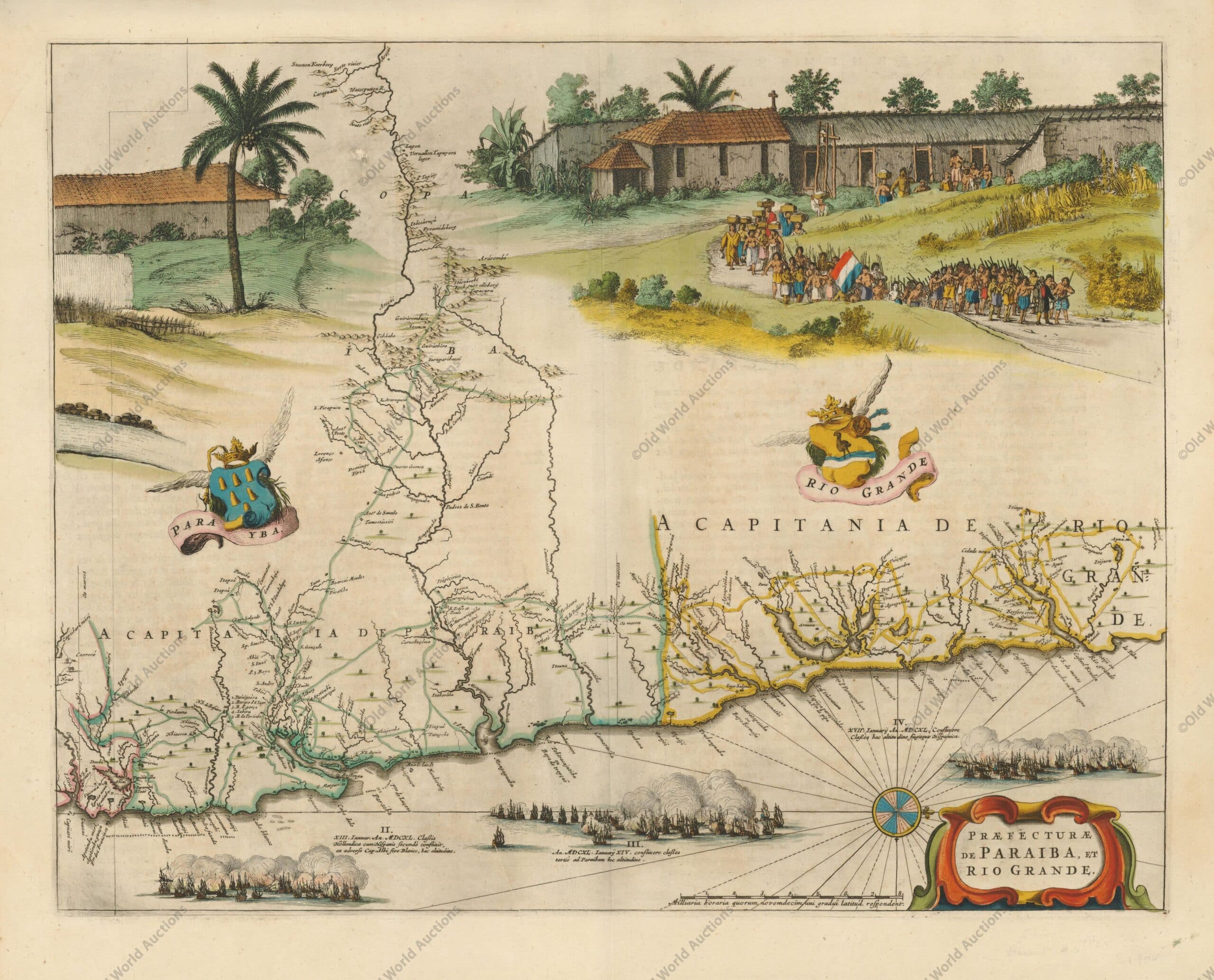

![Mapa do Hemisfério Ocidental de 1581 - Este é um dos mapas mais famosos da América e que teve enorme influência na futura cartografia do Novo Mundo. O mapa é baseado principalmente no grande mapa-múndi de várias folhas de Gerard Mercator de 1569. As características mais reconhecíveis do mapa são o litoral chileno bulboso e a largura exagerada do continente norte-americano. A América do Norte mostra um longo St. Lawrence River atravessando o continente para quase encontrar o fictício Tiguas Rio, que flui para o oeste. A cartela do título estrategicamente colocada esconde o desconhecido Pacífico Sul e, portanto, a maior parte do conjectural grande continente do sul, que é mostrado anexado à Nova Guiné e à Terra do Fogo.Este mapa é da segunda placa de cobre que contém geografia idêntica à primeira placa [1570]. Nesta placa, o maior navio do Pacífico está agora navegando para o leste e para longe do observador. Devido à perseguição religiosa, Ortelius foi forçado a deixar Antuérpia e, como resultado, houve um lapso de quatro anos na publicação do Theatrum. Quando ele se restabeleceu em Liège, ele usou a grande gráfica de Christopher Plantin para retomar a publicação com várias placas revisadas. Esta placa teve uma vida relativamente curta de apenas 8 anos, sendo substituída em 1587 com a placa facilmente distinguida da forma revisada da América do Sul.](https://3ad77b72.delivery.rocketcdn.me/wp-content/uploads/2022/11/Mapa-do-Hemisferio-Ocidental-de-1581-scaled.jpg "Mapa do Hemisfério Ocidental de 1581")


![Mapa do Hemisfério Ocidental de 1677 - O mapa de Visscher influenciou muito a cartografia das Américas, tanto geográfica quanto artisticamente. Um dos detalhes geográficos mais distintos copiados por outros cartógrafos é o grande lago aberto na região dos Grandes Lagos. Na verdade, Visscher copiou isso do mapa mundi de parede de Blaeu [1648], mas o popularizou neste mapa. A Califórnia é mostrada como uma ilha, no modelo Briggs, mas com uma costa norte mais ampla. O mapa é embelezado com duas grandes cartelas que também foram copiadas por outros cartógrafos. A cartela superior apresenta uma dedicação a Cornelius Witsen e retrata anjos lutando com um demônio pela alma de um nativo americano. A cartela do título pictórico contém cenas de extração de ouro, caça e um chefe nativo sob um guarda-chuva. Este é o segundo estado, com a adição do privilégio de Vischer.](https://3ad77b72.delivery.rocketcdn.me/wp-content/uploads/2022/11/Mapa-do-Hemisferio-Ocidental-de-1677-scaled.jpg "Mapa do Hemisfério Ocidental de 1677")


![Mapa do Brasil de 1757 - Part 1 - Este par de mapas gravados em cobre cobre o litoral do Brasil e mostra as Capitanias ou delegações portuárias hereditárias. O primeiro mapa vai de Salvador a Santos, e o segundo segue até Maldonado, no Uruguai. Há bons detalhes interiores de rios e montanhas. O tamanho varia um pouco. "[Lot of 2] Suite du Bresil Depuis la Baye de Tous les Saints Jusqu'a St. Paul [and] Suite du Bresil pour Servir a l'Histoire Generale des Voyages", Bellin, Jacques Nicolas.](https://3ad77b72.delivery.rocketcdn.me/wp-content/uploads/2022/12/Mapa-do-Brasil-de-1757-Part-1-scaled.jpg "Mapa do Brasil de 1757 - Part 1")
![Mapa do Brasil de 1757 - Part 2 - Este par de mapas gravados em cobre cobre o litoral do Brasil e mostra as Capitanias ou delegações portuárias hereditárias. O primeiro mapa vai de Salvador a Santos, e o segundo segue até Maldonado, no Uruguai. Há bons detalhes interiores de rios e montanhas. O tamanho varia um pouco. "[Lot of 2] Suite du Bresil Depuis la Baye de Tous les Saints Jusqu'a St. Paul [and] Suite du Bresil pour Servir a l'Histoire Generale des Voyages", Bellin, Jacques Nicolas.](https://3ad77b72.delivery.rocketcdn.me/wp-content/uploads/2022/12/Mapa-do-Brasil-de-1757-Part-2-scaled.jpg "Mapa do Brasil de 1757 - Part 2")


