Este post também está disponível em:
![]() Português
Português ![]() English
English

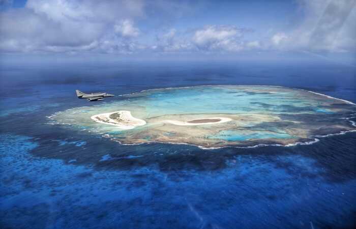
Atol das Rocas is the only atoll present in the western South Atlantic Ocean.
Atol das Rocas is located about 145 km west of the archipelago of Fernando de Noronha and approximately 260 km northeast of the city of Natal, in Rio Grande do Norte, being the only atoll present in the Western South Atlantic Ocean.
Atol das Rocas, one of the Brazilian islands, has high ecological importance due to its high biological productivity and for being an important shelter, feeding and breeding area for several species of animals.
Atol das Rocas was transformed into the first Marine Biological Reserve in Brazil on 5 June 1979.
The inclusion of the Atol das Rocas Biological Reserve in the World Natural Heritage list is based on the fact that they represent oceanic island ecosystems with highly productive waters, which provide food for tunas, sharks, cetaceans and sea turtles that migrate to the eastern Atlantic coast of Africa.
They are veritable oases of marine life in a relatively barren ocean, contributing to the reproduction, dispersal and colonisation of marine organisms in the tropical South Atlantic.
The islands are formed by limestone sediments, skeletons of fish, corals, birds, shell fragments and crustaceans; they have an equatorial climate and dense herbaceous vegetation.
Flying over the reserve, it is impossible not to observe the clouds of birds, about 150,000, of 29 different species. On dry land, the diversity is more remarkable: there are breeding, foraging, migratory, sporadic visitors and other species.
Birds of all kinds can be found in the reserve.
The Atol das Rocas, as a breeding area for sea turtles, especially the green turtle, is an important study station of the Tamar Project.
The vegetation is dense, typically herbaceous, resistant to salinity, excessive light and tidal action. The species have characteristics of halophytic plants. On Farol Island, there are two casuarina trees that are a support point for seabirds.
The Atoll is considered one of the most important areas for the reproduction of seabirds in Brazil, and where a multitude of birds can be found, including the Masked Tern, Brown Tern, Red-footed Tern, Black-browed Frigatebird, Brown Scallop and Black Scallop.

See the work “The Atoll das Rocas Unique Ecosystem in the South Atlantic Ocean”
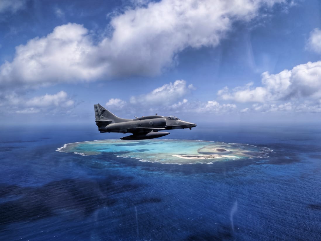
Two islands belong to Atol das Rocas
The two islands are about 3 metres above high tide and can be seen approximately 10 nautical miles away, depending on the direction of approach to Atol das Rocas.
1. Ilha do Farol
The 34,637 square metre Ilha do Farol was known by the French and English as Sable or Sand. Atol das Rocas is situated on a seamount belonging to the Fernando de Noronha Mountain Chain, of volcanic origin;
The current name is due to the construction of the first lighthouse in 1881, which was suspended because the tower did not meet the needs of the place. The lighthouse remains active and was inaugurated in 1967.
Covering some 34,600 square metres, 1 km long and 400 metres wide, it was known to the French and English as Sable or Sand.
The current name was due to the construction of the first lighthouse on the island in 1881, which was suspended because the tower did not meet the needs of the site. The lighthouse, which remains active on the island, was inaugurated in 1967.
2. Cemetery Island
Cemetery Island, covering 31,513 square metres, was also called “Grass” or “Capim”;
It took on this name because of the burials that occurred due to the various shipwrecks that occurred on the island and the death of lighthouse keepers and their families;
Little known by the Brazilian population, its distance from the continent can be considered as the main factor that hinders the access of visitors, an aspect also seen as a positive point because this territory is a conservation unit, protected by environmental legislation.
Only a few privileged people have been to Atol das Rocas, including fishermen, navigators and researchers;
With about 31,500 square metres, 600 metres long, by 150 metres wide, it was called Grass or Capim.
Videos about Atol das Rocas and the Formation of an Atoll

Reserva Biológica Marinha do Atol das Rocas - EP1
Reserva Biológica Marinha do Atol das Rocas - EP2
Reportagem sobre o Atol das Rocas04:40
Reserva Biológica Atol das Rocas01:00
Formação de um atol
ORIGIN OF ATOL DAS ROCAS
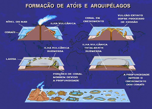
Atol das Rocas has its origin in the same fracture perpendicular to the Atlantic Dorsal chain, from which the Fernando de Noronha archipelago emerged (Fernando de Noronha Fracture Zone).
Like the archipelago, Atol das Rocas is the summit of an immense volcanic edifice, whose base is lost in the Atlantic abyss.
The difference between these two formations lies in their volcanic elevations, as while Noronha rose up to 323 metres above sea level, Rocas rose at sea level (more susceptible to wave action).

Over time, wave action reduced the entire ridge to a few metres – two or three – below the sea surface. The formation of this substrate close to the sea surface, due to the availability of light and nutrients, made it possible for colonies of calcareous algae and corals to occur.
The development of these colonies, on the edges of the submerged volcanic formations, gave rise to the circular-shaped reefs (due to the summit of the submarine volcano), with the presence of lagoons inside. This reef formation is called an atoll.
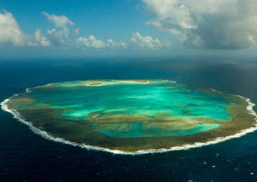
Atol das Rocas is shaped like a semicircular ellipse with an internal area of 5.5 m2. Its east-west axis is approximately 3.7 kilometres, and its north-south axis is approximately 2.5 kilometres.
Although the Atoll has small dimensions and the absence of a deep lagoon, a fact used as an argument for Rocas not to be considered a true atoll, its current morphology presents several characteristics that are found in atolls around the world.
Characteristics of Atolls
- the presence of a shallow lagoon and sandy islands to leeward of the reef, characteristic of Caribbean atolls;
- the existence of a ridge of coralline algae on the reef edge, a particularity of Indo-Pacific atolls;
- the greater extension of the reef ring on the windward side of the atoll.
In the geological fracture, of which Fernando de Noronha and Atol das Rocas are part, there are several other submerged mountains, aligned at the height (latitude) of Fortaleza, on the coast of Ceará.
Their summits are between 20 and 30 metres below the sea surface.
In the last 100,000 years, during the various glaciations, the sea became about 100 metres lower and these peaks formed a sequence of islands, more or less close to each other.
This made it possible for species to migrate for thousands of years from adjacent coastal environments, colonising distant environments such as the Fernando de Noronha archipelago and Atol das Rocas.
At the end of the ice ages, the sea level rose again and almost all the islands submerged. The species that remained fixed on the submerged lands of the remaining oceanic formations (Noronha and Rocas) survived.
With less height and fewer conditions than Fernando de Noronha, Atol das Rocas ensured less diversity and less noble species of flora and fauna.
A PAST OF LEGENDS AND NAUFRAGES IN THE ATOL DAS ROCAS
The history of men on Rocas Atoll is punctuated by legends, shipwrecks and many deaths. There are no clear records of who discovered the Atoll, perhaps because the discoverer was also shipwrecked.
Some authors attribute the discovery to Gonçalo Coelho, in 1503, in the same expedition in which he discovered Fernando de Noronha.
What is known for sure is that 16th century navigators were already afraid of its shallow reefs. Despite such widespread fear, persisting even after the era of motor boats and ships began, the precise location and recording of the exact coordinates of Atol das Rocas on navigation charts only happened in the last century, in 1957, in the International Geophysical Year.
During the 16th, 17th and 18th centuries, the atoll kept hundreds of captains’ eyes open, night and day, during the crossing between the Brazilian coast and the Fernando de Noronha archipelago.
Between 1803 and 1890, history has recorded five major shipwrecks on Atol das Rocas. Four of them occurred in October and one in March (the period when currents are most active).
The most famous shipwreck of that time was that of the Duncan Dubar, an English ship with more than 100 crew and passengers on board, mostly emigrants from Plymouth, England, bound for Sydney, Australia.
The Duncan Dubar hit the equatorial current while drifting through calms. It ended with its rudder destroyed and a huge gash in its hull on the night of 7 October 1865 as it crashed into the reefs of the Atoll.
Men, women and children only abandoned the ship the following morning, when the fury of the waves had already destroyed part of the side.
Crammed into the scalers, they miraculously crossed the surf unharmed and landed on the sand, where they remained for 10 days.
The rescue only happened thanks to the heroic gesture of Commander Swanson, who left the Atoll in a scaler, accompanied by six sailors, heading for the Brazilian coast.
Within five days, they reached the coast of Pernambuco and were lucky enough to come across another British ship, the Oneida. At the risk of sinking due to overcrowding, the Oneida took on board all the shipwrecked, ruined but alive, and with them embarked on the long journey back to England, without further incident.
In 1883, the installation of the first lighthouse reduced the fear of sailors, but gave wings to the legends of death, born of the loneliness of the lighthouse keepers. One of the tongues of sand was named Cemetery Island because lighthouse keepers, their families and shipwrecked people were buried there.
The absence of fresh water sources meant that the lighthouse keepers’ lives were precariously dependent on supplies from the mainland or on the hope of rainfall to fill the cisterns.
At the turn of the century, the wife and children of one of the lighthouse keepers reportedly died of thirst because one of the children left the cistern tap running dry.
The lighthouse keeper, desperate, set fire to the house to see if it would attract a ship, but help arrived late and only he survived.
Legend also has it that the souls of the woman and the children are trapped on the island of their misfortune and haunt visitors at night, asking for water.
Lighthouse lights – initially the traditional ones, and now the automatic ones – have reduced shipwrecks, but not eliminated them.
Even today, reefs betray the attention of helmsmen and abruptly interrupt dreams of travelling.
On 26 June 1979, the Mon Ami, a 13-metre sailing ship with two masts, sank.
Its crew, three South Africans and an Australian woman, spent 21 days in an improvised camp on the Atoll, sharing their sailboat’s provisions and rainwater with rats, mice, scorpions and cockroaches.
Despite persistent radio distress signals, lifeboats thrown overboard with pleas for help, and the beckoning of a plane on the eighth day, the Mon Ami castaways were only rescued on 16 July by a Brazilian Navy corvette, after another plane passed by and radio communication with a Norwegian tanker visible on the horizon.
CLIMATE OF THE ATOLL OF THE ROCAS
The climate of Atol das Rocas is tropical oceanic, softened by the trade winds from the east and southeast, which blow all year round.
Winds with speeds ranging from 6 to 10 m/s prevail throughout the year, but during the winter, winds with speeds between 11 and 15 m/s are common.
Wind speeds above 20 m/s are recorded more frequently during the summer. The average annual atmospheric temperature is 25°C, with February being the hottest month of the year and August the coldest.
Rainfall is unevenly distributed throughout the year. In general, there is less rainfall in April and more rainfall in August. The waters surrounding Atol das Rocas belong to the South Equatorial Current, which originates on the coasts of Africa from the Benguela Current.
The average water temperature in the outer part of the atoll is 27°C, however, in the pools present in the inner region of the reef, the water can reach 39°C.
BIOLOGICAL COMMUNITIES PRESENT IN THE ATOL DAS ROCAS
1. Characterisation of the flora of Atol das Rocas
The vegetation is typically herbaceous, resistant to salinity, excessive light and the constant action of the tides.
Some species have their own characteristics (they have their branches orientated towards the sea and structures resistant to burial that grow continuously, forming a tangle).
The species that occur on the atoll belong to the families Amaranthaceae, Aizoaceae, Portulacaceae, Cyperaceae, Gramineae and Amaryllidaceae. On Farol Island there are two dead casuarina trees that are support points for seabirds.
Of large size, there are only a few coconut trees introduced before the creation of the Reserve. In addition, there are some other plant species introduced by fishermen and sailors.
Composition of coral reefs and associated benthic communities At Atol das Rocas the reef surface is predominantly covered by macroalgae (about 110 species of macroalgae have been identified and catalogued, two of which are new to Brazil) and an association of encrusting calcareous algae and vermetid gastropods.
Massive corals, such as Siderastrea stellata, Montastrea cavernosa and Porites occur only in areas protected from wave energy, mainly in lagoons, tide pools and in some indentations of the reef front.
Although it is argued that coralline algae generally have a limited role in reef building due to ecological and environmental constraints and their low vertical growth rate, Rocas is an example that these organisms can grow vertically at relatively high rates.
Seven species of corals of the order Scleractinia have also been identified on the atoll. Sponges described total 38 species, most notably Spirastrella coccinea, Chondrilla nucula and Topsentia ophiraphidites.
Research indicates that the low degree of competition for species and the low rate of herbivory at the site may be ecological factors that have favoured the intense growth of encrusting coralline algae in Rocas, in addition to high hydrodynamic energy.
The diversity of crustaceans is also great, represented by 11 families and 18 species, especially the land crab, Gecarcinus lagostoma, and the aratu, Grapsus grapsus, species that occur only in oceanic islands.
2. FISH
In the waters surrounding the atoll, a large number of commercially utilised fish species are found, such as yellowfin tuna, some types of gulpons, striped grouper, grouper and whiting.
Researchers have so far catalogued about 147 species of fish in the reserve. Of these, two are endemic, that is, they occur only in Atol das Rocas and Fernando de Noronha: the Rocas damsel, Stegastes rocasensis, and Thalassoma noronhanum.
Although the biomass of herbivorous fish in Rocas is equivalent to that of reefs elsewhere in Brazil or the Caribbean, only one genus of grazing fish on coralline algae has been found in the atoll (genus Sparisoma).
Furthermore, the species of the genus mentioned have less powerful jaw muscles than parrotfish of the genus Scarus, which are the most powerful grazers in the reef ecosystem and do not occur in Rocas.
This difference in the structure of the Rocas fish community may also have contributed to the increased potential for growth and preservation of encrusting coralline algae, as herbivory by parrotfish is one of the most important ecological controls on coralline algae development.
Atol das Rocas holds the largest colony of tropical seabirds in Brazil (at least 150,000 birds of 29 different species). Five species breed (nest) on the Atoll, both on Farol Island and Cemitério Island.
They are: masked booby (Sula dactylatra), brown booby (Sula leucogaster), black-throated kinglet (Sterna fuscata), brown widow (Anous stolidus) and black widow (Anous minutus).
In addition to nesting species, there are constant migratory foragers, sporadic visitors and waders (living in mud and swampy terrain).
Two species of constant foraging seabirds can be recorded throughout the year from Fernando de Noronha, which use the coconut palms, dry bushes and ruins of Atol das Rocas as roosting sites and the surrounding areas to capture their prey: the red-footed booby (Sula sula) and the frigatebird (Fregata magnifi cens).
To date, five species of oceanic migratory birds have been recorded on Atol das Rocas, three from the north and two from the south.
Sparrows (Passer domesticus), with few individuals, can be recorded near the lighthouse, probably from vessels that visited the Atoll, as well as, sporadically, the heron (Bulbucus ibis), the yellow-billed pintail (Phaethon lepturus), the red-tailed godwit (Phaethon aethereus) and the Palaearctic wader – desert swallow (Glareola pratincola), as well as the marine species Sterna antillarum, which probably comes from the Caribbean and the Gulf of Mexico.
The last group of birds that can be recorded in the Atoll, one of the most spectacular due to its peculiar characteristics, is that of waders, coming from both the Northern Hemisphere and the Old and New Worlds, such as the curlews (Tringa spp), the batuíra-decoleira (Charadrius semipalmatus) and the fuselo (Limosa laponica).
3. SEA TURTLES
5 species of sea turtles found in Brazil.
The area also stands out for being the second largest nesting area for the green turtle Chelonia mydas in Brazil, as well as being a shelter and feeding area for the hawksbill turtle Eretmochelys imbricata.
The first agreement drawn up for the effective implementation of the Atol das Rocas Biodiversity Network was signed in 1990 between Ibama and the Pro-Tamar Foundation, which had the essential support of Petrobras in transporting the first shelter facilities.
Tamar was able to collect important data, not only on the reproductive biology of the green turtle, but also on the bioecology of juvenile individuals, both green and hawksbill turtles, which inhabit the area full of algae banks and coral reefs and sponges, which are the main food items of these species.
CONSERVATION STATUS AND MAIN THREATS TO THE ATOL
As previously mentioned, Atol das Rocas was declared a Marine Biological Reserve on 5 June 1979 and recognised as a World Natural Heritage Site by the United Nations Educational, Scientific and Cultural Organisation (UNESCO) on 13 December 2001.
Biological reserves mainly protect fauna and are theoretically closed to tourism and any kind of economic exploitation.
Theoretically, because it is very difficult to avoid the presence of fishing boats, ships and sailboats in the 36,000 hectares of protected area, including the submerged lands and the underwater limestone formations, in addition to all this being located about 260 km from the nearest coast (that of Rio Grande do Norte) and 145 km from Fernando de Noronha (the only inhabited island in the region).
Under current Brazilian law, to go down to the Atoll or dive in its waters you must have authorisation from the Brazilian Institute of Environment and Renewable Natural Resources (Ibama). Until 1993, this requirement was simply ignored by the vast majority of sailors and the curious, as there was no enforcement.
In 1993, a permanent post was built (two prefabricated wooden houses installed next to the ruins of the old lighthouse) for the teams of volunteers in Ibama’s fi scalisation rota.
The main concern of these teams is the increasing boldness of industrial fishing vessels in the prohibited fishing waters, as well as possible spills of diesel and other pollutants, sometimes brought in from the high seas by currents.
As on most oceanic islands, mice (Mus musculus), scorpions (Isometrus maculatus), cockroaches (Periplaneta americana) and other pests have been inadvertently introduced to the atoll and have proliferated there, according to reports in recent years from lighthouse keepers and some castaways.
Such invasive organisms travel clandestinely on boats and ships, hidden in the supplies or cargo being transported.
So far, there is no evidence that these species interfere directly with the eggs or birds, although they compete for space and may, in the future, jeopardise the ecological balance of the islands, with their ecosystems always more fragile than those of the mainland, given the isolation and the exiguity of the environment.
Atol das Rocas – Origin, Biology, Climate and Shipwrecks
Northeast Tourism and Travel Guide


