Este post também está disponível em:
![]() Português
Português ![]() English
English

Pitambu is located on the north coast of Sergipe, in a region known as the Mangrove Coast, the city of Pirambu is one of the most visited in the state.
With a privileged location, at the mouth of the Japaratuba River, bathed by the Pomonga River and the Atlantic Ocean, the city is considered one of the largest fishing centers in the northeast.
Currently, the municipality has a population of approximately 9 thousand inhabitants and has shown development in recent times.
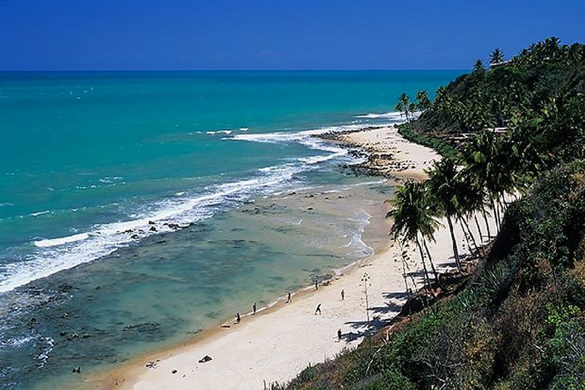
Each year Pirambu reinforces its vocation for tourism. Lagoons, dunes, mangroves, trails and waterfalls are perfect settings to enjoy good times and relax.
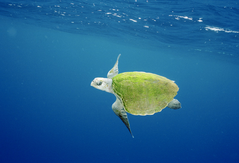
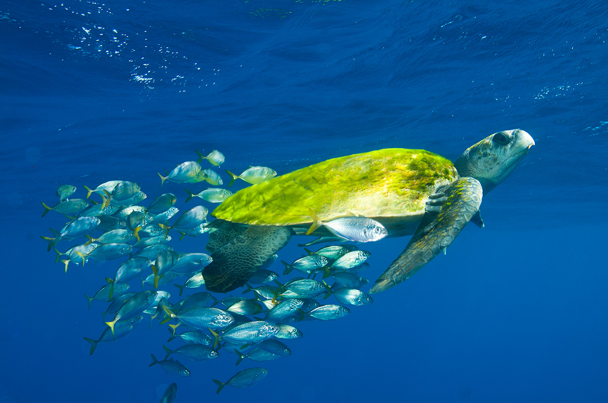
It is also worth checking out the Santa Isabel Ecological Reserve, which is maintained by the Tamar Project and houses one of the main centers for the study of turtles and spiders.

In addition to the natural beauty, the large number of parties and events throughout the year attracts thousands of people from various parts of the country.
This characteristic makes Pirambu the ideal place to enjoy ecological tourism, leisure and the pleasures of the table, with the diversity of fish and seafood, as well as entertainment in bars and nightclubs.
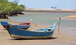
Those who visit there will confirm the fame of the abundance that is evident mainly of shrimp. At the mouth of the Japaratuba River, there is the fishing terminal that in the fishing period moves more than 40 boats sliding to the high seas, being part of one of the beautiful scenarios of the beach.

The return of the boats moves the city’s economy, the two ice factories spawn their production, the traders who take shrimp to cities like Salvador, Maceió and Recife take turns waiting for the product always absorbed by the market.
The siri patola that is fished in the high seas and was discarded for ignorance of the flavor, is now very disputed because a fry of the same has equal or superior flavor to any shrimp dish.
Videos about the north coast of Sergipe

Pirambu em Sergipe
Ponta dos Mangue em Sergipe
Reserva Biológica de Santa Izabel
Espécies de Tartarugas no Brasil

Pirambu - Drone03:53
Pirambu SE - Reportagem03:41
Conheça as belezas de Pirambu 03:26
Pirambu – History and Tips
For some sources, the nomenclature of the municipality comes from a common fish in the region (the pirambu), for others it comes from the name of an indigenous chief who inhabited the old settlement.
The settlement, initially called “Ilha”, was inhabited by fishermen at the beginning of the 20th century, who practiced subsistence fishing in the Pomonga and Japaratuba rivers and in the Atlantic Ocean, as well as hunting and agriculture.
Trade was based on barter and the houses were made of straw. In 1911 a commercial house was installed and the fishermen’s colony was founded. In 1912 the village became a town, where the church was built in honor of Our Lady of Lourdes. In 1934 with the emancipation of Japaratuba from Capela, Pirambu rose to the status of a village.
In the 60s of the twentieth century, a group of local leaders initiated a movement for the political emancipation of Pirambu. João Dória do Nascimento, councilman of Japaratuba; Manuel Amaral Lemos, rural producer; Abelardo do Nascimento and José Lauro Ferreira, fishermen; and Xavier dos Santos headed the movement.
On November 26, 1963, the bill presented by state deputy Nivaldo Santos was sanctioned, which elevated the village to the category of municipality with the name of Pirambu, dismembered from Japaratuba. With the popularity, the councilman from Japaratuba João Dória do Nascimento was elected the first mayor of Pirambu, taking office in August 1965.
The municipality has an average annual temperature of 26ºC with an average rainfall of 1650 mm/year, with a longer rainy season between March and August (autumn-winter).
The relief is represented by coastal plains (dunes, floodplains and marshy shallows); coastal trays and hills. Its vegetation varies from hygrophilous and mangrove, restinga, capoeira, caatinga, cerrado, clean and dirty fields. The municipality is inserted in the hydrographic basin of the Japaratuba River.
Access to the municipality from Aracaju is via the Construtor João Alves Bridge (Aracaju/Barra dos Coqueiros) following the SE-100 highway, on a route of about 31 kilometers of dunes, beaches and mangroves.
The Japaratuba is the main river of the municipality, with the Sapucaia, Brito, Poxim and Papagaio rivers in its territory (the Pomonga River flows into the Japaratuba River at the limits with Santo Amaro das Brotas, but does not run through Pirambuense soil).
Also noteworthy are the lagoons, such as Pirambú, Catu, Camurupim, Titaras, Redonda, Grande, Seca, Santa Isabel and Sangradouro, the largest in Sergipe, flowing into the Atlantic Ocean, in the village Lagoa Redonda.
Tourist Attractions of Pirambu
Santa Izabel Biological Reserve
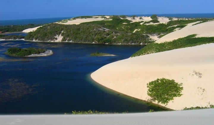
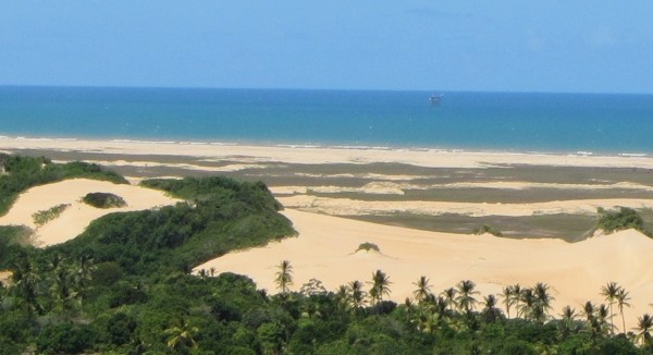
It has 2,776 ha and 45 km of beaches. It was created by decree on 20/10/88 to protect delicate coastal ecosystems composed of fixed and mobile dunes, mangroves and temporary and permanent lagoons.
Reserva Biológica de Santa Izabel
In addition to the important occurrence of sea turtles, it is a region of protection of other important classes of animals and plants.
Ponta dos Mangues beach is part of the Santa Isabel biological reserve, an environmental preservation area. The beach is deserted, perfect for those seeking tranquility and a good swim.
The name of the place is due to the large presence of mangroves. The biological reserve has an environmental preservation area of six thousand hectares – the equivalent of nine thousand soccer fields. It was created 25 years ago to preserve the ecosystem formed by mangroves, lagoons and dunes, which are very close to the beach. The sand carefully draws natural pools, shallow and deep.
The construction of houses and visitation are controlled by environmental agencies. Therefore, there are few options for accommodation. The inns charge, on average, R$ 100 a day for two people.
A suggestion of a walk very close to the beach is to visit the village Junça, to know the work that the artisans do with the straw. The pieces are sold, on average, for R$ 30.
Walking another ten minutes you will find a fishing village. It is located on an islet that was formed over the years with the sand brought by the river. The fishermen themselves are the guides on the tours through the mangrove that borders the village. The tour for five people lasts half an hour and costs R$ 60.
Dune Trail
There are 14 kilometers of beautiful and immense golden dunes. On the way, typical coastal vegetation and the panoramic view of the Santa Isabel Ecological Reserve.
Roncador Waterfall

Roncador Waterfall is located in the middle of the dunes, 1 km away from the sea.
It can be reached by a short walk along little frequented paths.
Prehistoric Stone
In the aguilhadas we find a landmark that, according to scholars, indicates the passage of the Phoenicians 1,600 years ago (BC). On the Arapiraca farm, where the stone is located, bones of prehistoric animals have already been found.
Mirante
Plateau located in the village of Aguilhadas. Panoramic view of the Serra de Itabaiana, the city of Aracaju and the Port of Sergipe.
Boat trip to Japaratuba and Mangroves
Join the boat ride through the Japaratuba River estuary and mangroves, washed down with lots of coconut water and exotic tropical fruits from the region; and at the end of the journey, taste seafood such as crab, aratu and shrimp, accompanied by your favorite drink or delicious fruit juices. This gastronomic and ecological adventure surpasses everything you can imagine.
The mangrove represents a fundamental ecosystem for the ecological balance and preservation of species that find in it the habitat to guarantee their survival, such as herons, crabs, oysters, guayamuns and other not very well known species, which are also part of this ecosystem, which is respected by the local residents, maintaining a harmonious coexistence there.
Lagoa Redonda

Lagoon located 19 km from the seat of the municipality; receives this name for its shape. It surrounds a local mangrove area and is surrounded by a wall of sand.
From the top of its dunes you can see the ocean at one end and the mangrove at the other.
There is a stream that flows into it and passes through an area of dunes known as the “little desert”; also nearby is the so-called “Cachoeira” do Roncador, actually a small waterfall. The sand walls on the shores of the lagoon are used for sandboarding.
Lagoa do Sangradouro
Large lagoon, located 22 km from the municipal headquarters, also in the vicinity of the village Lagoa Redonda.
In the region there are several clusters of dunes, among them the Morro da Lucrécia (at whose base is the Lagoa encantada) with a height of between 25 meters, where sandboarding is practiced; as well as perennial lagoons such as the Blue Lagoon.
Tamarar Project
The reserve was created in 1998 with the aim of preserving and recovering the coastal ecosystems of the region. It is located in the municipalities of Pirambu and Pacatuba, covering about 45 km of beaches.

The reserve is home to the largest Brazilian breeding site of the olive ridley turtle, and is also an important spawning area for several other species of turtles (hence the partnership with the Brazilian Sea Turtle Conservation Program, TAMAR), as well as a landing and resting area for migratory birds and a diverse resident fauna.10
The first Tamar base built in Brazil was installed in 1982 in Pirambu, municipality of Sergipe, with monitoring of 56km of breeding and feeding beaches of sea turtles.
TAMAR’s Environmental Education Center receives an average of 120,000 visitors a year and many students.
The Base has four tanks with sea turtles in various stages of development; lecture room and film projection; anteroom with a marine aquarium and six aquariums with freshwater fish, representatives of the species surrounding the Reserve; parking lot and stand for the dissemination of cultural activities developed with the surrounding communities; other educational materials.
How to get to Pirambu
In the direction of Aracaju to Maceió by BR-101, enter at Km 48 in the direction of Japaratuba then following to Pirambu. Other arrival options, or if you prefer by BR 101 towards Santo Amaro das Brotas.
By the bridge Construtor João Alves, which connects Aracaju-Barra dos Coqueiros, the distance is shortened to 30 km.
Location
Located 30 km from Aracaju, between the municipalities of Japaratuba and Barra dos Coqueiros on the axis of the North Coast.
Tourism and Travel Guide of Pirambu in Sergipe and Northeast Brazil


