Este post também está disponível em:
![]() Português
Português ![]() English
English

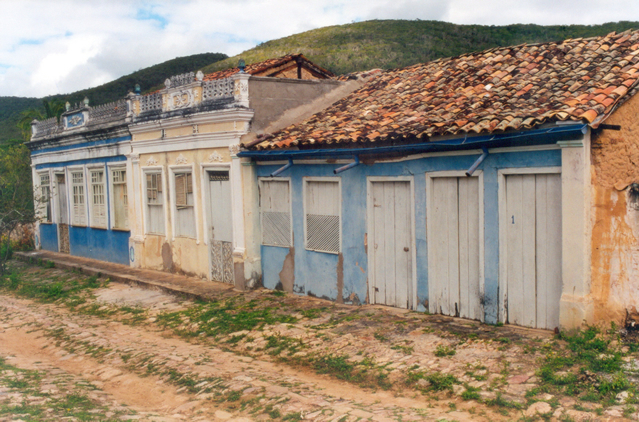
Vila do Ventura originated with escaped miners from the municipality of Lençóis and the discovery of diamond and carbonate.
Vila Ventura in the municipality of Lençóis
Fugitive prospectors from the municipality of Lençóis, around 1840 take shelter in the grottos of the farm of Col. Porfírio Pereira near a waterfall (today makes. Várzea da Cobra) one of the prospectors was called Ventura.
Soon the prospectors discovered diamond and carbonate in the Village of Ventura, installed a small mining cut under the protection of Col. Porfirio and began to sell the stones in the city of Lençóis, having been Ventura (prospector) responsible for selling the first diamonds, the name “VENTURA” became the reference of the place where the diamonds came from.
This Ventura was soon talked about throughout the mining region and so many other prospectors began to settle the new promising lands. It is also known that before the mining was installed in Ventura, there were already some filling houses there.
Between 1840 – 1864 there was a good phase of growth, buildings and emerging commerce. However, on the occasion of the Paraguayan War and the consequent conscription of a good part of the men, the small village goes into decay.
After the war, a new phase was established and the village grew again, and in the first three decades of the last century it reached its peak.
State Law No. 680 of August 27, 1906, creates the District of Ventura.
We noticed already at that time a strong trade that was gradually settling in the Commercial square (today Cel. Dias Coelho square) two schools one state and one municipal and some private teachers where they taught the Portuguese and French language, Post Office, Association of Employees of the Trade of Ventura, Theater, Philharmonic December 25, founded in 1907, cemetery and a chapel.
Map of the Trails and Tourist Spots of Chapada Diamantina
The main income of the district was the trade of carbonate which was traded directly on the European market. One of the causes of the decline of this trade was the introduction of a synthetic element that replaced carbonate, this at the end of the twenties of the last century.
Nowadays, Vila do Ventura is an appreciable historical site for the development of research on a period when diamond, carbonate and the colonels were the subject of all times.
Video about Vila do Ventura and Rupestrian Trail in Morro do Chapéu
Vila do Ventura e Trilha Rupestre no Morro do Chapéu
Rupestrian Paintings – Rupestrian Trail in Morro do Chapéu
.
Distant 390 km from Salvador, Morro do Chapéu has more than 10 sites that gather paintings in caves and rocks, with an infinity of waterfalls, walls, canyons and the largest concentration of orchids of Bahia.

The city, located at an altitude of over 1,000m, is also a paradise for fans of extreme sports, the right route for abseiling, mountain biking, trekking and caving.
Toca da Figura, in the Ventura region, has a landscape composed of blocks of rock that form shelters and burrows in the middle of the valley.
The site’s large panels show men lined up, animals in motion, hunting scenes and men climbing trees. The paintings at Toca da Figura combine different colors in the same drawing, such as red, yellow, brown and white.
Nearby, the Toca do Pepino is a large shelter, which must have been used by hunters; it consists of a large wall, about 90 meters long, full of paintings.
The paintings on the walls indicate a set of images of the Northeast Tradition, with very small human figures, a large group of men lined up and scenes composed of rituals that include men with headdresses and tools, such as baskets, clubs and spears.
The Gruta da Boa Esperança, 53 km from Morro do Chapéu, has rock paintings and a kind of altar that suggests it was a place for religious rituals.
In Lagedo Bordado, on the banks of the Salitre River, the rock art appears on a rock, where there are also animal footprints. For those interested in paleontology, the Toca dos Ossos, in Ourolândia, is a place full of fossils.
Morro do Chapeú in Chapada Diamantina
First inhabited by the Paiaiás Indians, at the beginning of the 16th century, Morro do Chapéu earned its name due to the more than 1,200m hat-shaped Morrão, which reigns absolute in the air. It was only in 1909 that it was elevated to the category of city. Its history dates back to the coronelismo and the diamond cycle in Bahia.

Surrounded by a multitude of waterfalls in Chapada Diamantina – highlighting the Ferro Doido, with its 118m of waterfall -, large walls, canyons and caves, the landscape of Morro do Chapéu enchants by the diversity of natural beauties.
The region is home to one of the largest concentrations of orchids in Bahia, and is the natural habitat of the golden hummingbird, a rare species of hummingbird present in the region.
The city, located at an altitude of more than 1,000m, is also a paradise for fans of extreme sports, the right route for abseiling, mountain biking, trekking and caving.
But not only ecological tourism lives Morro do Chapéu. Within the urban perimeter, the beautiful buildings stand out, such as the parish church of Nossa Senhora da Graça, from 1834, the chapel of Nossa Senhora da Soledade, from 1911 (built by Dias Coelho, the most illustrious of the colonels of Morro do Chapéu), the City Hall building, from the 19th century and the house of Father Magalhães, from the same century.
Rupestrian Trail in Morro do Chapéu and Vila do Ventura
Chapada Diamantina Tourism and Travel Guide


