Este post também está disponível em:
![]() Português
Português ![]() English
English

The Archipelago of Tinharé or Archipelado de Cairu has 26 islands and is home to the most desired destinations of tourists to the beaches of Morro de São Paulo, Boipeba, Garapuá and Moreré, right paths for those looking for sun and beach, only 173 km from Salvador by land and 60 km by nautical route.
The islands always have special programming during holidays and weekends.
As summer approaches, the islands of the Tinharé Archipelago, belonging to the municipality of Cairu, are preparing to receive tourists from Bahia and from various parts of Brazil and abroad;
The municipality has more than 400 km2 of natural beauty.
The archipelago gathers 26 islands and it is from there that are some of the most sought after beaches of the Baixo Sul: Morro de São Paulo, Boipeba, Garapuá and Moreré are destinations for natives and tourists in short and long seasons.
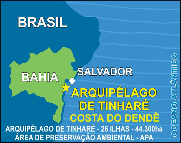
The Archipelago of Tinharé is also one of the only municipality-archipelago in Brazil, the municipality of Cairú, based on the island of the same name.
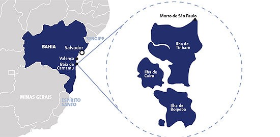
Morro de São Paulo is located at the northern end of the island of Tinharé, an island that makes up, along with Boipeba, Cairú and 23 other small islands, the Tinharé Archipelago.
Access Map to Morro de São Paulo
The archipelago is about 60 kilometers south of Salvador, near the city of Valença.
View the map of Costa do Dendê
The islands are separated from each other and from the mainland by large mangrove channels, a fact that makes access difficult to the point that even today many places are uninhabited and rarely visited, since navigation is dependent on tides and access by land almost impossible.
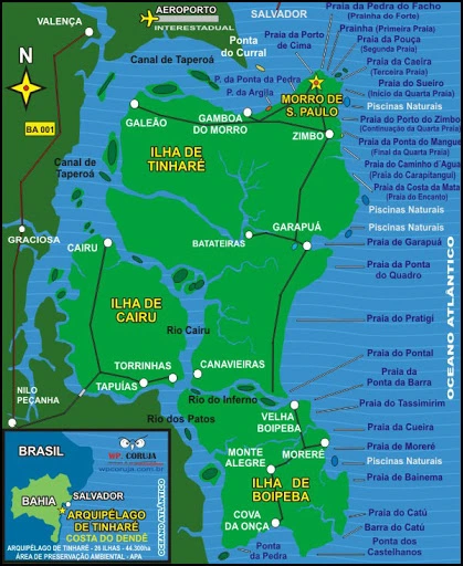
The most accessible part of the archipelago is the east coast, where the beaches are. The water is deeper, although almost all the beaches are protected by reefs, and you can reach the beach only at a few specific points.
The channel to the north of the island of Tinharé is also deep, although it has sandbanks, and it is through it that you reach Ponta do Curral and the city of Valença, both on the mainland.
The other channels are shallow and treacherous. Only those who know the region well venture to navigate them, and even then, not at any tide.
Arquipélago de Tinharé - Morro de São Paulo, Boipeba, Gamboa e outras ilhas01:42
Arquipélago de Cairu - Pontos Turísticos 02:15
See the complete tourism guide about the Cairu Archipelago, also called Tinharé Archipelago!
The archipelago has about 451 square kilometers, with Tinharé being the largest island, with 54% of this area. Boipeba and Cairu have a similar area, about 20% of the archipelago each. The other 23 islands account for less than 7% of the total area.
The highest elevations are located to the north of the island of Tinharé, where there is a lighthouse, and to the northwest, in the locality of Galeão.
The rest of the island is practically flat and only a few meters above sea level. The islands of Boipeba and Cairú are more undulating, but their elevations do not exceed 80 meters.

There are almost no roads, only paths that are traveled on foot, on horseback, or when conditions permit, by tractor. The transportation of goods is practically all done in wooden boats, the sloops.
The villages are all located along the sea and the navigable channels. On the island of Tinharé they are: Morro de São Paulo, Gamboa, Galeão, Zimbo, Garapuá and Canavieira.
On the island of Boipeba, Velha Boipeba, Moreré, Monte Alegre and São Sebastião or Cova da Onça.
Cairú, besides the seat of the municipality, has the village of Torrinhas.
The archipelago has a total of 11,410 inhabitants, who, although the islands are of different sizes, are divided more or less equally into the three inhabited islands.
Basically the villages depend on activities linked to the sea, mainly fishing, and more recently on tourism.
The population is a mixture of blacks and Europeans, mainly Portuguese, but also Dutch and Indians.
The people are generally very quiet and friendly. Very humble, and very willing to welcome visitors.
A large part of the islands was originally covered with Atlantic Forest, but today, much of it is occupied by huge coconut groves, although there are still considerable areas of virgin forest.
There are also large areas of restinga, but the most important ecosystem of the archipelago is the mangrove, which is the great nursery of marine life and serves as a source of sustenance for much of the population.
Since 1992, the islands of Tinharé and Biopeba have formed an environmental preservation area. However, some problems persist, such as the disposal of garbage, although great progress has been made, such as sewage treatment.
Some NGOs are now working to provide more profitable and environmentally friendly alternatives for the local population. Of course, the future of the archipelago depends on everyone, the population, businessmen, public authorities and tourists.
Tinharé Archipelago Tourism Guide in Bahia


