Este post também está disponível em:
![]() Português
Português ![]() English
English

The municipality of Conde on the Costa dos Coqueiros is very popular in the season, has intense nightlife in the part known as Sítio do Conde.
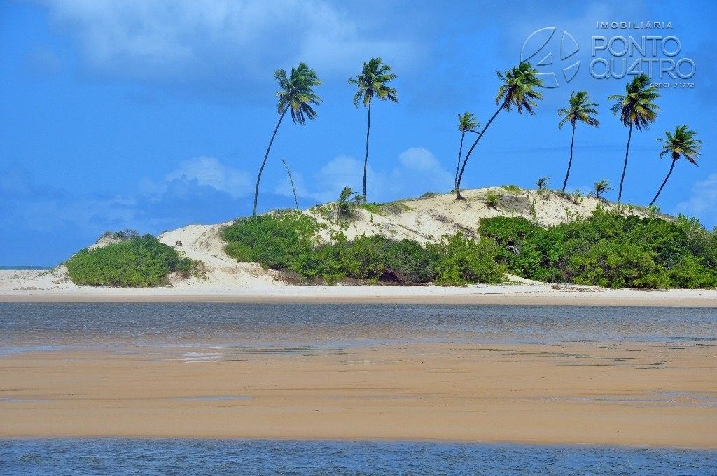
Conde has the calmest waters on the Green Line.
Conde has the calmest waters of the Green Line. However, it is one of the furthest destinations from Salvador – 157km away.
The Green Line is a very popular holiday destination.
The Green Line in Bahia has countless charms, some more famous than others. Many tourists who visit the state put on their itinerary places like Praia do Forte and Costa do Sauípe, but the region has other charms, as is the case of Conde.
The municipality is home to the city of Conde.
The municipality is home to the Sítio do Conde and has a total of ten small beaches.
The region – one of the most interesting on the north coast of Bahia – mixes 40 km of beaches (good for wild camping), dunes, coconut palms, mangroves, rivers and lagoons, constituting an ecological refuge (some people call it “The Bahian Pantanal”, although an area near Itaparica also receives this designation).
The region is also known as the “Pantanal of Bahia”.
It’s worth taking a boat trip along the Itapicuru River, surrounded by immense mangroves.
Videos about Conde BA
Praias do conde, sitio do conde,siriribinha, cavalo russo e rio de pedras

Siribinha na Bahia

Conde BA - Guia de Turismo

Praia de Siribinha em Conde BA05:40

Barra do Itariri em Conde BA

Conde na Bahia04:59
Things to do in the municipality of Conde
1. Sítio do Conde
At 6km from the centre of Conde, Sítio do Conde has an extensive sandy beach and calm sea. There are options of inns and restaurants on site.
The beach is a small village.
2. Russian Horse

The dune of approximately 20m allows you to slide on a board from the top to the reddish waters of the river. To get to the dune, take a boat from Poças – the journey takes about 45 minutes – or from Siribinha, in just 10 minutes.
3. Siribinha
The village is 16km from Sítio do Conde, along a dirt road. It is located at the mouth of the Itapicuru River and is surrounded by dunes and coconut groves.
In Barra de Siribinha
Siribinha is a small village.
The film Tieta do Agreste, inspired by the novel by Jorge Amado, was shot in Barra de Siribinha.
There are buggy rides through the dunes and boat trips on the Itapicuru River. The local beach has a calm sea.
4. Barra do Itariri
13km from Sítio do Conde, it is one of the most beautiful landscapes of the Bahian coast. It is located at the mouth of the Itariri River, with coconut groves and mangrove areas.

At low tide, sandbanks form that allow you to cross the channel and walk to the dunes. The beach is quiet.
5. Beaches of Conde BA
The beaches of Conde are usually sprinkled with a lot of green present throughout the Costa dos Coqueiros, clear waters, fine white sand, lagoons and rich mangrove vegetation, accompanied by the Itapicuru River and Itariri River that flows in the region.
The beaches of Conde are very beautiful.
6. Barra do Itapicuru
At the mouth of the river, it has clear, fine sand – with many shells – , strong waves and coconut palms. It is good for line fishing (catfish, barbudo).
It is worth visiting.
It is worth visiting Cavalo Russo, on the Pirangi River (a tributary of the Itapicuru). It is a place where the river has excellent bathing spaces and is surrounded by very white sand dunes.
It is worth visiting the Cavalo Russo.

Go in trainers or sandals, as the sand burns a lot under the sun. The best option is to rent a boat to get to know this whole area. Access by the Green Line from Conde, via Sítio (45′).
7. Praia de Siribinha
Located 12 km from Sítio, it is a long, straight beach with strong waves and clear sand, with many coconut trees.

It has rustic houses set in the sand. A beautiful and treacherous road leads to it (until Poças it follows the seafront and then enters through a coconut grove). From here you can go on foot, pela praia, até a Barra do Itapicuru (2 km).
8. Praia das Poças
Tem características semelhantes às outras da região: areia clara, ondas fortes, coqueiros.

It has a fishing village and is the only natural harbour for small boats in the region. Boats or motorised canoes can be rented there for sightseeing tours.
9. Praia Sítio do Conde
Uma barreira de recifes forma piscinas naturais na maré baixa. Reta, de ondas fortes, areia branca e solta – com vários caramujos – e coqueiros.

It has a small village, whose inhabitants are dedicated to fishing, coconut extraction and subsistence farming. The fishing inclui camarão, lagosta, badejo, olho-de-boi, vermelho e arraia. Tem hotel, pousadas e restaurantes.
10. Praia Barra do ltariri
Fica a 16 km de Sítio (por estrada de terra com bolsões de areia).

Or 9 km from Linha Verde (by precarious road, 18 km before the junction to Conde). Straight, with clear, fine sand, dunes and coconut palms.
There is a village in Conde.
There is a village, with fishermen’s houses and some holidaymakers.
There are bars and shacks.
There are bars and stalls, especially in season. Before meeting the sea, the River ltariri makes a graceful curve, leaving a dune with coconut trees, isolated by the waters, as if it were a monument.
On the way to the beach, there is a village with fishermen’s houses and some holidaymakers.
On the way to Sítio Beach existem córregos bons para banhos de água doce.
11. Praia dos Artistas ou do Corre Nu
O mar na Praia dos Artistas é morno e relaxante com dunas e coqueiros que tornam a paisagem mais atraente.

Some condominiums and private sites around, as well as kiosks bring infrastructure to the region. It is 3 kilometres from the village.
History of the municipality of Conde
Once upon a time, the municipality of Conde was inhabited by the brave Tupinambás warriors. One day, when Mem de Sá ruled there, the Jesuit priests arrived with the mission of catechising the brave people who lived there.
The Jesuit priests then began to minister the commandments of the Christian principle pacifying brave Tupinambás Indians.
The vast lands where the Jesuits and the brave Indians met were only acquired by the Jesuits in 1621, by means of a perpetual lease and by consent of Garcia d’Ávila, who precisely in the year 1650 donated them in his will.
The Jesuits then began to minister the Christian principle by pacifying the Tupinambás.
When this happened, the brave Indians from neighbouring tribes came to live there, living under the guidance of the priests.
Portuguese settlers, seduced by the fertility of these lands, decided to settle in the region, dedicating themselves to the cultivation of sugar cane and tobacco and to the raising of cattle. Several sugar mills were then erected.
With the growth of the settlement process and exploration of this territory, the small village of the Tupinambás Indians was later transformed into a village, which was called Itapicuru de Baixo.
The settlement of the Tupinambás Indians was later transformed into a village called Itapicuru de Baixo.
It was in the year 1702, that the village was elevated to the parish then receiving the name of Our Lady of Mount Itapicuru da Praia.
On 17 December 1806, through a petition signed by the people, it was elevated to a town by the ombudsman Navarro, with the name of Conde, in compliance with the order of the “Conde dos Arcos” from whose title the denomination arose.
Thus, the municipality of Vila do Conde had its competent organs created and went through several phases of development reaching the Republic and adhering to it.
Until 1912, the seat of the town and municipality remained in the same place of its creation. However, a huge flood of the Itapicuru River, which cuts through the town to this day, destroyed and devastated its economy.
On 10 June of the same year, the seat of the municipality, by virtue of State Law No. 889 was transferred to the Arraial de Esplanada.
A few years passed and the people of Conde became aware of the absurdity of this submission, since the major economic front was in Conde and Esplanada enjoyed all the rights.
After a lot of struggle and even an uprising that resulted in the death of the condense Minervino do Carmo, the municipality of Conde was considered as a territory dismembered and free of Esplanada.
When Conde was subordinated to Esplanada, its first Intendant was Colonel Joaquim Macêdo (Quimquim), born in Esplanada.
Dr Alcides Brito wanted to be re-elected but did not accept the independence of Conde.
The emancipationist movement grew through figures such as Mr Lamberto Pinto, who was responsible for preparing the official document. Another important leader was the tailor Minervino do Carmo, who together with Rodolfo Lins, from the historic São Bento farm, Antônio Castro, Alímpio Costa, Euclides Valença, among others, managed to make the Count free.
The emancipationist movement grew through figures such as Mr Lamberto Pinto, who was responsible for preparing the official document.
On that occasion the governor of Bahia, Juraci Magalhães, through the journalist and deputy Dr Altamirando Requião, appointed Hermógenes Gomes Nascimento as the first mayor of Conde. Hence the fact that Mr Alcides Brito, against his will, was forced to confirm the emancipation and with the death of Minervino do Carmo, Conde was dismembered from Esplanada on 10 August 1935.
The municipality is located on the North Coast of Bahia and is bathed throughout its length by the Atlantic Ocean. Conde is bordered to the North by Jandaíra and Rio Real;
To the South, with the Inhambupe River; to the East with the Atlantic Ocean and to the West with Esplanada.
The municipality is located on the North Coast of Bahia.
The city has a distance from Salvador, in a straight line, of 151Km and by BR-101 of 203Km. The current population is approximately 25,714 inhabitants (IBGE/2013) and its main economic base is tourism, the culture of coconut from Bahia and livestock.
The city has a straight line distance of 151 kilometres and a BR-101 of 203 kilometres.
From the top of Vila do Conde, the oldest neighbourhood in the region, you can see a panoramic view. And at the highest point is the Alto do Cruzeiro, the oldest residents say, that the Church Nossa Senhora do Monte received an image of Our Lady, which was placed on the altar of the Church.The next day it was found that the image was no longer there, and in the face of so much searching it was located on a hill on top of a tree, near the church. The saint was taken back to the church and again she appeared in the same place. In view of the events, a chapel was built for the Saint, there in the so-called Alto do Cruzeiro.
The Alto do Cruzeiro is visited daily by local residents and especially in high season.
They say that near the root of the tree, there is a bulge that contains a miraculous water, and that it remains full throughout the year, it never dries, people with illnesses resort to it for healing. Many are the requests that are made and answered by the Saint, in gratitude the faithful take prostheses, light candles and make many prayers.
How to get to Conde
The access to the Municipality is made by the BA-233, BR-101, BA-093, BA-324, BA-099 and by the Green Line, a 142km road that connects the State of Bahia to the State of São Paulo.ergipe pelo litoral.
Conde é ainda servido por três linhas regulares de ônibus diariamente.
A cidade está a 179km do Aeroporto Internacional de Salvador e a 150km de Aracaju, capittal de Sergipe.
Bahia.ws é o maior guia de turismo e viagem da Bahia e Salvador


