Este post também está disponível em:
![]() Português
Português ![]() English
English

Itaparica Island is the largest island in the Bay of All Saints with 240 km2, Itaparica means “fence of stones” and the name comes from a coral reef that is 1 km from the beaches facing the Atlantic.
Itaparica Island, the largest sea island on the Brazilian coast, is connected to the mainland by the Funil Bridge, it houses the municipalities of Itaparica and Vera Cruz; the latter occupies 87% of the island’s territory.
The settlement on Itaparica Island began in 1560 by the Jesuit priests who settled in the village of Nosso Senhor da Vera Cruz, today called Vila de Baiacu.
Cradle of the first Brazilian family, born from the union of the Indian Paraguaçu with the Portuguese Diogo Álvares “Caramuru”, Itaparica is marked by pioneering spirit.

There, the first dam in the country was built and, later, the first industrial steam engine to operate in Brazilian territory was installed.
View the map of Baía de Todos os Santos
Famous for its mineral waters, it was elevated to the category of Hydromineral Resort in 1937.
Itaparica is also the birthplace of writer João Ubaldo Ribeiro, author of Sargento Getúlio, Viva o Povo brasileiro, O sorriso do lagarto and a casa dos Budas Ditosos, among others.
Itaparica Island offers visitors ecotourism options, mineral springs and beautiful beaches that, protected by coral reefs, have calm waters, great for swimming and diving.

Videos about Itaparica Island and its history
Ilha de Itaparica - Reportagem

Ilha de Itaparica - Dicas
7 Melhores praias de Vera Cruz22:57
Praia da Penha na Ilha de Itaparica04:04
Guia de Turismo da ILHA DE ITAPARICA - Dicas
O BRASIL COMEÇOU NA ILHA DE ITAPARICA25:49
Itaparica Island is home to the municipalities
- Itaparica
- Vera Cruz, the latter occupies 87% of the island’s territory
1. Tourist attractions of the village of Itaparica

In the village that is the seat of the homonymous municipality, located at one end of Itaparica Island, you cannot miss visiting the Historical Center.
1.1. Igreja de São Lourenço e Igreja Matriz do Santíssimo Sacramento
The Church of São Lourenço, patron saint of the island, built with lime, stone and whale oil, in Baroque style in 1610, and the Mother Church of the Blessed Sacrament inaugurated in 1719, where you can admire the beautiful panels representing the Holy Supper and the miracles of the Blessed Sacrament, painted by Manoel Teófilo de Jesus, one of the most talented artists of sacred art of the time.
The Church of São Lourenço is regarded as the guardian of the rains and winds and is the patron saint of Itaparica Island. In 1638, from the pulpit of this church, Father Ferreira protested against the invasion of the city by heretics from Holland.
1.2. Craft Center
In the same region is the Centro Artesanal, installed in the Solar Tenente Botas in Praça dos Tamarindeiros, also known as Largo da Quitanda, where the nightlife happens.
1.3. Sacatar Institute

At Rua da Alegria 10 is the Instituto Sacatar, a space where local artists work.
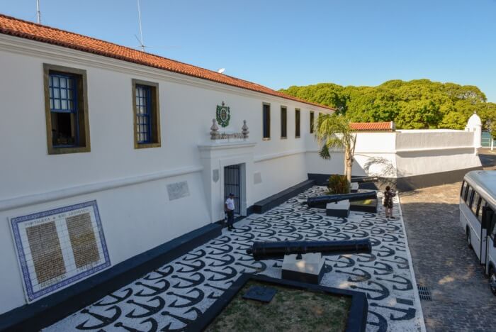
In the village of Ponta de Areia is the Fort of São Lourenço, built in the 18th century on the ruins of old Dutch fortifications. One of the most violent battles of the war of independence took place there in 1822.
1.4. Bica Fountain
The Bica Fountain, on Rua 25 de Outubro, has mineral waters of proven medicinal action. There you will see the inscription-“Fine water. makes véia virá menina”.
This famous fountain has been a reference for safe water supply since the 16th century.

Because of it, in the first half of the 20th century, Itaparica was named a hydro-mineral resort.
Known for the “purity of holy water” and the mineral properties of its water, it is recommended for curing diseases, especially digestive disorders. Its main medicinal property is diuretic.
For a long time it has also come to be called the “Fountain of Youth”.
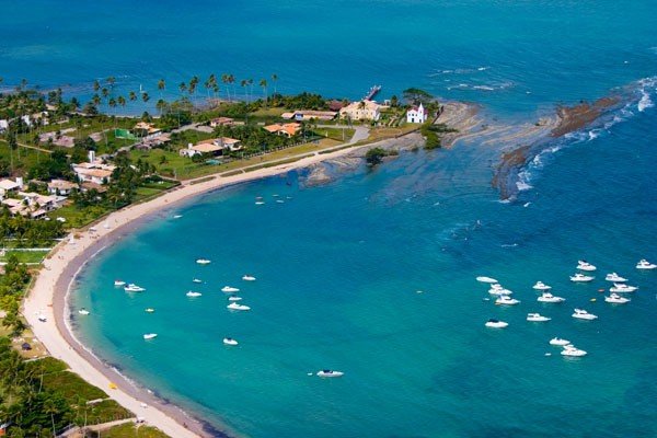
1.5. Ponta de Areia Beach

The municipality has very popular beaches, such as Ponta de Areia Beach (3 km from the center), with calm waters and great movement of boats and schooners.
1.6. Amoreiras Beach
Praia de Amoreiras (3 km from the center, continuation of Ponta de Areia), whose edge is covered by almond trees that provide shade.
1.7. Manguinhos Beach
Praia de Manguinhos (3.5 km from the center), occupied mainly by summer houses. has calm sea, good for swimming and water sports.
1.8. Porto dos Santos Beach
The beach of Porto dos Santos (4 km from the center), semi-deserted. is surrounded by dense vegetation of the Atlantic Forest. In the vicinity there is a village from where the trail leads to the Fonte dos Milagres, a place considered mystical, much sought after by followers of candomblé.
The so-called miracles are attributed to an old black man named Wenceslau, who cured his blindness by washing his eyes with water from the fountain.
1.9. Praia da Gameleira
Praia da Gameleira (12 km from the center) is good for bathing, water sports and fishing.
1.10. Ilha do Medo
Ilha do Medo, inhabited only by wild cats, is full of mysteries and stories of hauntings. It is said that a Jesuit priest received money to celebrate a mass and did not do it.
When he died, his spirit is said to have been trapped on the island, appearing to people and inviting them to attend the mass he did not say in life. The “hauntings” of the island would be the lepers who lived in an asylum that existed there in the 19th century.
The fearless can rent a boat at Ponta de ltaparica and check it out.
2. Tourist Spots of the Municipality Vera Cruz
The municipality of Vera Cruz, which has as its headquarters the city of Mar Grande, is well prepared to welcome visitors, has historical monuments, vast areas of environmental preservation, mangroves, beaches, islets and a lot of folklore.
For nautical sports, parachuting and diving, it is paradise.
The waters that bathe Vera Cruz are home to a great diversity of marine life. The population’s main livelihood is fishing, which offers visitors the opportunity to savor a varied menu based on fish and seafood.

2.1. Bahia wetlands on Itaparica Island
Beautiful region of mangroves and canals where you can see many and varied animals. Called an “ecological sanctuary”.
It encompasses the southwest coast of Itaparica Island and the stretch of mainland opposite.
The uniqueness of the region lies in the combination of rivers that mix fresh and salty waters, canals, mangroves, beaches of very white sand and Atlantic Forest, where birds, wolves, anteaters, foxes, pacas and armadillos live, fish such as whiting, mullets and dentons.
The coast of Itaparica facing the channel is a region of mangroves, with small, poor fishing villages.
The island of Matarandiba has white sandy beaches and coconut palms. The city of Jaguaripe, a port founded in the 16th century by the Portuguese to load caravels with palm oil, coconut and piassava, holds some curiosities: it is all connected by underground tunnels, which in the past were used by residents to defend themselves from attacks by Indians.
In the basements of the Municipal Palace, now transformed into the House of Culture, the fearsome Prison of Salt operated, whose cells were flooded by the sea during high tide.
2.2 Baiacu Ecological Park
Although still in the implementation phase, it is also excellent for walks, in which you can see the ruins of the church of Senhor de Vera Cruz, from the 16th century, and see specimens of the typical flora of the region, such as the sacred gameleiras of candomblé.
2.3 Cacha-Pregos Beach
It exists and is located in Cacha-Pregos or, better explained, where Judas lost his boots, at the southern end of the island of ltaparica.

The lively village has inns and restaurants and is the starting point for boat trips to the Pantanal Baiano, Matarandiba Island, where the Tororó Fountain is located, Saraíba Island, Pinaúnas Reef and Caramuanas Reef, a natural pool in the middle of the sea, with clear waters and multicolored fish, among the most popular.
The beach of Cacha Pregos, with calm waters, has a fascinating sunset.
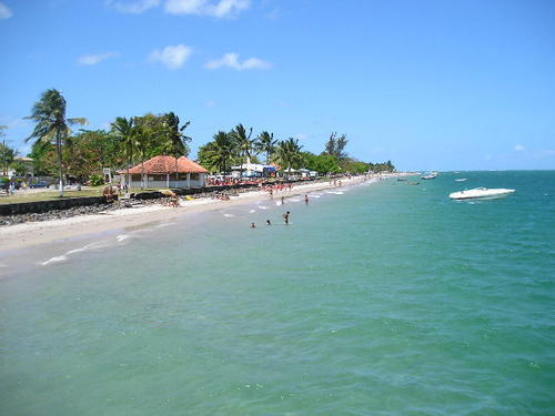
3. Beaches of Itaparica Island

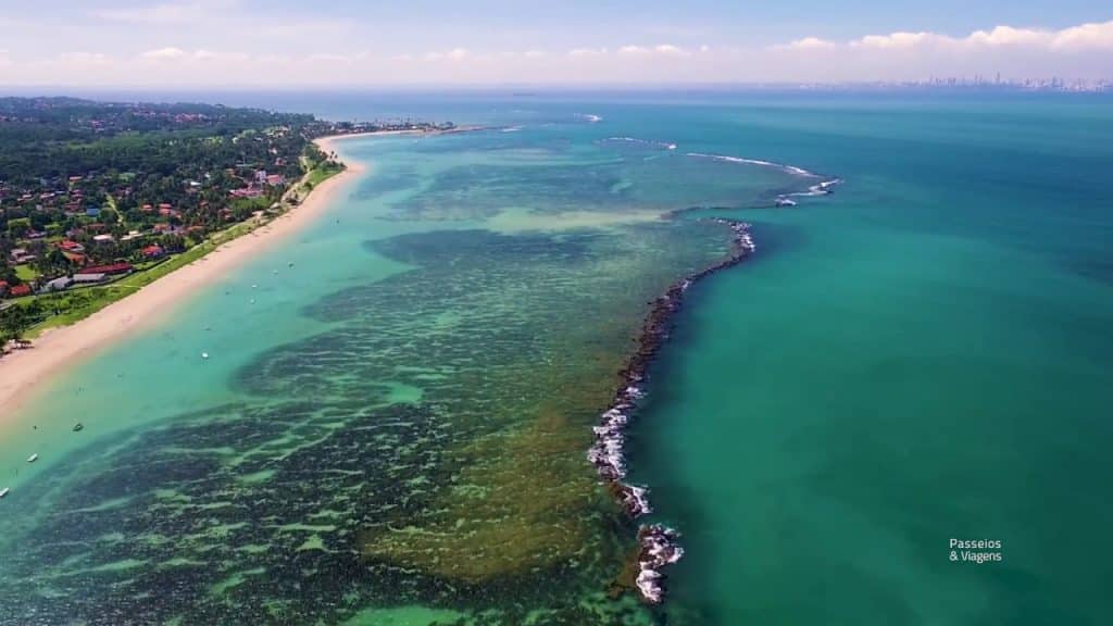
A coral reef 1 km from the beaches facing the Atlantic creates a large natural pool, good for swimming (with clean and warm waters), water sports and diving (the outer face of the corals is conducive to spearfishing).
Located only 17 km from Salvador, Itaparica Island is almost an extension of the capital of Bahia, with great condominiums and summer houses.
It is divided into two municipalities – Itaparica and Vera Cruz -, has almost two beaches and has some colonial buildings.
There you can rent boats for trips, bicycles, kayaks, horses and kombis to go around the beaches.
Itaparica Island can be reached by ferry (which makes the connection of approximately 1 hour between the terminals of São Joaquim, in Salvador, and Bom Despacho, on the Island – in this there are buses, cabs and rental cars), by speedboats (which leave the Tourist Terminal, behind the Mercado Modelo, towards Mar Grande Beach) or by land, through the road that leaves the BR 101 and joins the west side of the Island to the mainland.
3.1. Praia do Forte
Next to the historic center of the city of Itaparica, its main attraction is the Fort of S. Lourenço (1711), witness of a past in which Itaparica was a sugar cane producer, target of the greed of pirates and Dutch and center of struggle for the independence of Brazil. There is also the Fonte da Bica (medicinal mineral waters).
3.2. Praia Ponta de Areia Beach
Shallow and almost without waves. It has stalls, a village and summer houses, Very popular, it is good for fishing.
3.3. Praia das Amoreiras Beach
Next to a village, it has summer houses and bars on the sand. Access to these beaches, from the asphalt, is quite precarious.

3.4. Manguinhos Beach
Mainly occupied by summer houses, it has calm sea, good for swimming and water sports.
3.5. Porto dos Santos Beach
Semi-deserted. surrounded by dense Atlantic Forest vegetation.

In the vicinity there is a village from where the trail that leads to the Fonte dos Milagres, a place considered mystical, much sought after by candomblé followers.
The so-called miracles are attributed to an old black man named Wenceslau who cured his blindness by washing his eyes with the water from the fountain.
3.6. Gameleira Beach
It is good for bathing, water sports and fishing. It is in front of a village, with narrow streets and old houses, already in the municipality of Vera Cruz. It has a hostel and stalls with food and drinks.
3.7 Mar Grande Beach
In the seat of the municipality of Vera Cruz. Urbanized (old buildings), with Porto do Duro (boats to Salvador). Some stretches are known as Jaburu, do Duro, Ilhota and Gamboa. It has several inns, camping and bars.

3.8. Praia da Penha
The most sophisticated, with good summer houses and a beautiful view of Salvador. A gap in the reef wall turns Ponta da Penha (where there is a chapel in honor of Nossa Senhora da Penha) into one of the few surfing spots on the island.
3.9 Barra do Gil Beach
It is in front of a fishing village and a gated community occupies part of the waterfront. It is about 1 km long, without waves, with clear and fine sand. Access on gravel. It has a hostel.
3.10. Crown Beach
With 2.5 km, it has many coconut trees. It has condominiums, summer houses and fishermen. No infrastructure. Access by land.

3.11. Barra do Pote
Like the previous ones, it has a view of Salvador.
No waves, with clear and fine sand. It is in front of a fishing village and has summer houses. Access on land. It has a hostel with a restaurant.
3.12. Conceição Beach
It has 2 km, with water and sand similar to the previous ones.
In a fishing village there are bars and improvised restaurants. To the south of the center is the Nossa Senhora da Conceição Church (18th century).
Further on Méditerranée security guards and jetties that go into the water make it difficult (but not prevent) access to the beach in front of the hotel.
3.13. Barra Grande Beach
It has 4 km, with coconut trees and fine dry sand. Some stretches are known as Cardoso, Parapatinga and Pedras. In the latter another fault in the wall of reefs allows the practice of surfing. It has hotel, inns and camping.
3.14. Beach Tairu
It has very green water, clear and fine sand and coconut trees, It is one of the most beautiful of the island. It has summer houses, a village, condominiums and a vacation colony,
3.15. Aratuba Beach
The presence of several condominiums makes access to the beach difficult.
Between October and January the tide, when low, forms an arm of sand 3 km long. It is good for spearfishing. It has inns and a youth hostel.
3.16. Beach Berlinque
It has little infrastructure (grocery store, public telephone). It has about 3 km, calm waters and clear sand. There are summer houses and a fishing village. It has inns, bars, restaurant and camping.
3.17. Cacha-Pregos Beach
Surrounded by coconut palms, without waves, with a view of Salvador, it has a hotel, inns, camping and several stalls, It is very popular in the summer.
The village of the same name has five shipyards (which manufacture sloops and schooners).
The expression “cacha-pregos” – which became popular as a synonym for a very distant place – in archaic Portuguese means “esconde-pregos” (fish that enter the bar of the Jaguaripe River and do not know how to return to the sea). Boats can be rented there to visit the “Pantanal Baiano”.
4. Other islands in the Baia de Todos os Santos
4.1. Tidal Island
The beaches of this island located right in the middle of the Bay of All Saints, some of which are almost deserted, have calm waters and natural pools.
The main ones are Praia das Neves, Itamoabo, Ilha de Maré, Praia Grande. Praia de Santana and Oratório da Maré.
In the village of Itamoabo is the Church of Santana, from the 17th century, and 1 km to the south in Praia das Neves, is the Chapel of Nossa Senhora das Neves from the 16th century.
The first-rate handicrafts consist of bobbin lace, baskets and bamboo objects. The island has a good tourist structure.
4.2. Ilha dos Frades
Small, has no means of accommodation. but it is one of the most visited.
In it is the village of Ponta de Nossa Senhora. The attractions are the rich vegetation typical of the Atlantic Forest, with hiking trails, the churches of Nossa Senhora do Loreto and Nossa Senhora de Guadalupe, both built in the seventeenth century, the ruins of a lazaret and the great beaches. Some, with calm waters, are ideal for bathing, water sports and diving.
Others are deserted, such as Praia da Viração, which is popular with naturists. The most frequented beaches are Paramana, Ponta de Nossa Senhora, Loreto, Viração, Tobar and da Costa
4.3. Ilha de Bom Jesus dos Passos
Very close to Ilha dos Frades. Here, nature is exuberant and flowery. The population’s livelihood is fishing and carpentry.
The attractions are the Church of Bom Jesus dos Passos, the Solar dos Duarte, and the fountains of Rua do Porãozinho and Grande. The beaches of Pontinha and Ponte do Padre are good for swimming and water sports.
4.4 Ponta do Garcez (Garcez beach) in Jaguaripe

The great attraction of this point of land that goes out into the sea are the blue, red and yellow bromeliads that proliferate along the beautiful beaches.
Rare specimens such as the maned wolf and the bush pig live there. Pure beauty, right at the mouth of the Jaguaripe River.
Itaparica Island Travel and Tourism Guide in Bahia
Bahia.ws is the largest travel and tourism guide for Bahia and Salvador.


