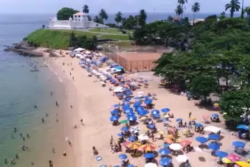
The Todos os Santos Bay and its recesses are an immense amphitheatre where nature, history and culture come together to form a beautiful setting for nautical tourism and ecotourism activities.
This magnificent setting is made up of a vast expanse of calm waters from which 56 islands emerge.

There are beaches, forests, trails, rivers, waterfalls, rapids, mangroves, ecological reserves, ruins of sugar mills, old churches and convents, testimony to the opulent wealth of the sugar plantations that sprang from the massapé lands.
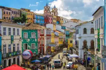
The landscape is dominated by the city of Salvador on the Bay of All Saints, which for more than two centuries was the capital of Brazil and the most important city in the Americas.
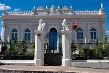
A city of art, with its baroque excesses, Salvador’s colonial architecture was reflected in the towns that grew out of the sugar mills of the Recôncavo Baiano, where we can see the urban ideals of Renaissance Portugal.
Alongside these strong traces of colonisation, a unique mixing of European, African and indigenous cultures has led to the emergence of a rich folklore, cuisine and artistic manifestations that combine the influences of the three races in just the right proportion.
The Baía de Todos os Santos Natural Park was created in June 1999 to protect the islands, organise socio-economic activities in the region and preserve areas of great ecological importance.

Todos os Santos Bay
-
- HISTORICAL AND CULTURAL ASPECTS
- A TREASURE TROVE OF BEAUTY AND HISTORY
- NAUTICAL TOURISM
- ECOTURISM
1. HISTORICAL AND CULTURAL ASPECTS
- Legend of the creation of Todos os Santos Bay
- First European explorers
- Ponta do Padrão and the Fort of Santo Antônio da Barra
- Geography of Todos os Santos Bay
- Indigenous presence and colonisation
- Relations between the Tupinambás and the French and Portuguese
- Arrival of Christopher Jacques and the battle against the French corsairs
- Legend of Caramuru
- Founder of the Captaincy of Bahia de Todos os Santos
- Tupinambá uprising
- The transformation of the Recôncavo Baiano and its sugar cane heritage
1 Legend of the creation of the Bay of All Saints
An Indian legend, recorded by the chroniclers of the early days of the settlement of Brazil, tells how, at the beginning of the world, a great bird with very white feathers set out from afar and, flying night and day without stopping, reached the coast of a vast land, where, exhausted from the long journey, it fell dead.
Its long, white wings, spread out on the ground, turned into white beaches.
Where the heart struck the earth, a great, deep depression opened up, into which the waters of the sea entered, its shores fertilised by the blood of the legendary bird.
Thus, the primitive rulers of the land – the Tupinambás – believed that Kirimuré was born, the vast Bay of gentle waters and its Recôncavos, which the white Europeans would later call the Bay of All Saints.
2. The first European explorers
Although the record is sparse, the first European to enter these sheltered waters seems to have been the Portuguese navigator Gaspar de Lemos, commander of the supply ship of the squadron of Pedro Álvares Cabral, who was ordered to carry the letter from Pero Vaz de Caminha with the happy news of the discovery to the king of Portugal, D. Manuel, O Venturos . Manuel, O Venturoso.
This messenger ship, which left Porto Seguro on 2 May 1500 bound for Lisbon, probably anchored in Todos os Santos Bay on 5 May.
However, the official discovery is attributed to the Florentine cosmographer Amerigo Vespucci, who entered the broad headland of this bay on the first of November 1501 in one of the six ships of the exploring expedition of Gaspar de Lemos, the same pilot of the messenger ship.
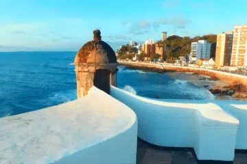
3. Ponta do Padrão and the Fort of Santo Antônio da Barra
It was customary in those days to name the places where one docked according to the saint of the day on the calendar, and so the Bay of All Saints was named, the great bay “capable of sheltering, without confusion, all the squadrons of the world”, as a foreign traveller visiting Bahia described it centuries later.

Gaspar de Lemos‘s expedition stayed here for about five days.
A stone pillar – a padrão – was erected on a rocky point of the bar that separates the Bay of Safe Waters from the open sea, which the Portuguese used to place in places they discovered, as a sign of ownership and dominion over the land.
For many years the site was known as Ponta do Padrão.
Between 1583 and 1587, the Forte de Santo Antônio da Barra or Barra Fort was built on the site of the monolith with the Coat of Arms of Portugal, and its Lighthouse still warns ships of the presence of Rocks and Plots at the entrance to the bay.
The site became known as Farol da Barra (Barra Lighthouse), a name that has remained unchanged.
Turning around at Ponta do Padrão, you can see Todos os Santos Bay in all its vastness.
An immense amphitheatre with an outline of about 200 kilometres, cut out by inlets, lagoons and a small bay, Aratu.
4. Geography of Todos os Santos Bay
The mouth, the large south-facing inlet between Ponta do Padrão and Ponta do Garcez, is about 18 nautical miles (33km) long. Its length in a straight line is 50km, from the mouth to the town of São Francisco do Conde; and 35km in a west-east direction, from Paripe to the mouth of the Paraguaçu river.
There are 56 islands of various sizes in the bay: Madre de Deus, dos Frades, Maré, do Medo, Grande, Cajaíba, Bimbarras, das Vacas, Maria Guarda, das Fontes, Bom Jesus dos Passos, Pati and, to the south-west, the largest, Itaparica, with an area of 246 km.
Halfway around the western edge of the bay flows the Paraguaçu, an indigenous name meaning large river. About 36 kilometres south of the mouth of the Paraguaçu, the Jaguaripe river (or yaguar-y-be, “river of the jaguar“) flows into a place known as Barra Falsa da Baía de Todos os Santos.
5. Indigenous presence and colonisation
At the beginning of the colonial era, the bay and its recôncavos were inhabited by the Tupinambás Indians, who had recently expelled the Tapuias, the original lords of the land, to the interior.
In Bahia, the Tupinambás dominated along the coast, from the mouth of the São Francisco River to beyond the Jaguaripe River, where the territory of the Tupiniquins began.
 e uma mulher tupinambá com uma criança (à direita) - Albert Eckhout, 1641")
The vastness of the waters of the Bay of All Saints offered ships a safe anchorage and earned it the favour of sailors along Brazil’s extensive coastline.
French privateers had been visiting the unguarded shores of Bahia since 1504. They were attracted mainly by the lucrative clandestine trade in Brazilwood, the red dye of which was used extensively by the textile industries of Flanders.
This trade reached such proportions that it at one time took precedence over the trade of the Portuguese, the masters of the colony.
6. The relationship of the Tupinambás with the French and Portuguese
The French knew how to make alliances with the Tupinambás, which facilitated bartering. Eduardo Bueno‘s interpretation in his book Capitães do Brasil: a saga of the first colonisers is clear: “It didn’t take the Tupinambás long to realise that the Portuguese were different from the French.
Unlike the French, who had come to Bahia only to collect Brazilwood – exchanging their goods as friends and leaving as friends without arousing suspicion – the Portuguese had come to stay and, as well as taking possession of the land, were prepared to enslave the natives“.
In other words, the French did not arouse the suspicions of the Tupinambás, unlike the Portuguese, who were their future masters.
For many years the Bay of All Saints did not have a single Portuguese settlement, and trade with the French prevailed, who made friends with the Indians who inhabited its shores and islands.
7. Arrival of Cristóvão Jacques and the fight against the French corsairs
In 1526, a Portuguese squadron commanded by Cristóvam Jacques was sent to Brazil to drive the French privateers off the coast.
When this coastguard squadron entered the Bay of All Saints, it encountered three French ships carrying Brazilwood in the Paraguaçu River, at the entrance to the Iguape Lagoon, in what is still called the French Island.
The battle lasted a whole day. The French were defeated and three hundred of their crew were taken prisoner.
8. Legend of Caramuru
The clandestine trade in Brazilwood found in Bahia a kind of commercial agent for the French: the Portuguese Diogo Álvares Correia, who went down in history with the legendary name of Caramuru.
He was shipwrecked on a possibly French ship that ran aground on the reefs and rocks on the sea shore one kilometre north of the bar of the bay in 1509 or 1511, at the place now known as Mariquita Beach, the name being a corruption of the Tupi word mairaquiquiig or “shipwreck of the French”.
The fact that it emerged from the sea among the rocks led the Tupinambás to call it Caray-muru, which in the language of the Tupinambás means a fish with an elongated body like a eel that lived among the rocks.
Some authors prefer that the name comes from “the white man who got wet or drowned”.
However, legend has it that the castaway came out of the sea and shot a bird with the rifle he had collected on board, leaving the Indians so perplexed that they called him “the son of fire” or “the son of thunder”.
Caramuru lived among the Tupinambás for 47 years, marrying the famous Indian Paraguaçu, daughter of the powerful chief Taparica, lord of the cannibals on the island of Itaparica, and having many children. They married in France, probably in 1525, where the Indian was baptised and given the name Catharina, in honour of Queen Catharina de Médicis.
Legend has it that when Caramuru left for his overseas wedding, a local woman threw herself into the waters of the bay and swam after the French ship carrying her ungrateful lover until she met her death. Her legendary name survives: Moema, mbo-em in the language of the Tupinambás, “the fainthearted”, “the exhausted”.
In the Bay of All Saints it is difficult to separate history, based on documents, from story, an imaginative expression of the facts.
Caramuru‘s influence was great in the early days of settlement. It is curious that French pilots, smugglers of brazilwood, called the place at the entrance to the bay, known to the Portuguese as Ponta do Padrão, Pointe du Caramourou.
9. Founder of the Captaincy of Bahia de Todos os Santos
At the end of 1535, the nobleman Francisco Pereira Coutinho arrived in Bahia to settle the captaincy granted to him by King João III .João III, by the letter of donation signed in Évora on the fifth of April 1534.
The Captaincy of Bahia (Capitania da Bahia de Todos os Santos) had fifty leagues (300km) of frontier, counted from the mouth of the São Francisco River to the tip of the Bay of Todos os Santos, including the Recôncavo Baiano of the latter, including the islands found, and, for the hinterland and terra firme, up to the limit of Castile, the Meridian of Tordesillas.

The Captain-Donee settled near the site where Caramuru lived, with his Indian wife, Mameluke children and sons-in-law.
On the site now known as Porto da Barra, Pereira Coutinho built a seaside settlement to be the official seat of the Captaincy, Vila Velha or Povoação do Pereira.
About a year later, the grantee had a deed of donation drawn up granting Caramuru a sesmaria, thus confirming the lands he had occupied with his people.
10. Tupinambá revolt
It didn’t take long for the Tupinambás to realise that this new wave of invaders, who had come with the Grantee, was gradually taking over their lands, forests and rivers.
They also oppressed the goyim into slavery, even selling them to other captains. This oppression could have no other outcome: the Tupinambás rose up en masse against the invading whites.
This revolt was triggered by the death of the son of one of the indigenous chiefs, which was attributed to a relative of the donee himself.
It is true that Caramuru helped the newcomers by providing food and facilitating relations with the Indians, but he was not an ally of all the Tupinambás. Nor could he have been.
There were many Indian villages scattered along the coast and in the Recôncavo, divided into different tribes, each with its own chief, who guarded their forests and fishing grounds.
And it was not uncommon for them to go to war against each other, taking prisoners whom they roasted and ate in great feasts or sold as slaves to outsiders.
The Tupinambás banded together and with about six thousand warriors – their faces dyed black with jenipapo, alternating with the bright red of urucum, which gave them a terrifying appearance – they burnt fences, destroyed mills, killed several Portuguese and besieged the survivors in Povoação do Pereira.
“It was five or six years of great hardship,” reported the mill owner and historian Gabriel Soares de Souza in 1580, “suffering great famines, diseases and a thousand misfortunes, and the Tupinambá people killing people every day.
As well as this war, the grantor also had to deal with the treachery of some convicts and settlers who, because of internal rivalries in the captaincy, allied themselves with the Indians and incited them to fight.
As for Caramuru, he doesn’t seem to have taken a stand against the Indians who besieged the seat of the captaincy. However, it seems that he was the one who led the old Grantee to flee to the Captaincy of Ilhéus. As a result, the Tupinambás laid waste to the city.
While the Captaincy of Bahia was adrift, the French, friends of the Indians, planned to settle there, spurred on by their ambition to make Brazil a French possession.
This threat of possible French domination motivated Francisco Pereira Coutinho to return to his domains. It was Caramuru himself who persuaded the grantee to leave Porto Seguro, where he had taken refuge, and return to Bahia with the promise of peace for the Indians.
In 1547, on the return journey, the ship carrying Pereira Coutinho ran aground on the treacherous Pinaúnas reefs at the southern tip of the island of Itaparica.
This tragic episode was described by Eduardo Bueno: “The Donatário and most of his companions were saved, but were captured by the Tupinambás. When they realised that Pereira was among the prisoners, the Tupinambás decided to kill him.
The one who wielded the club was a five-year-old Tupinambá boy, the brother of a native whom Pereira himself had ordered killed. In the ritual sacrifice, the boy was helped by an adult warrior to deliver the blow that ended the life of Francisco Pereira Coutinho.
The tribe then devoured donatário‘s body in a noisy anthropophagic feast.
Almost nothing remained of the nine years of Pereira Coutinho‘s administration. The mills that had been built in the Recôncavo were burned down by the Tupinambás. Vila Velha do Pereira, what was left of it, returned to its original state as a “simple Mameluke nest”.
The tragic death of the old and ruined Francisco Pereira Coutinho led to a complete overhaul of the administrative system of Brazil, which had long been studied in Lisbon. In general, the whole system of hereditary captainships had failed.
On Friday 29 March 1549, before the sun had set behind the island of Itaparica, the prows of three large ships, two caravels and a bergantim, entered the calm waters of Todos os Santos Bay.
The Portuguese fleet was commanded by Tomé de Souza, “Captain of the Settlement and Lands of Bahia, de, Todos os Santos and Governor of the Lands of Brazil“, titles he had held since his appointment on 7 January 1549.
He had come to found “a great and strong fortress and settlement”, the city of Salvador da Baía de Todos os Santos.
A few months before the arrival of the Governor, an emissary of the King sent a letter to Diogo Álvares Caramuru, announcing the arrival of the Armada and, above all, that he should stock up on supplies for Tomé de Souza and his entourage.
With the death of the donator, Caramuru had become the most important man in the captaincy and had already received a promise from the Tupinambás to cooperate with the “new” colonists.
Although skirmishes with the Indians continued, the governor, with the help of Caramuru, managed to establish peace between the settlers and the Indians.
Further into the bay, to the north, less than half a kilometre from Vila do Pereira, under one of the bluest skies in the world, the Governor built the fortified city on a cliff facing west, overlooking the Bay of All Saints.
The Indians worked with the many craftsmen who built the city under the orders of Master Luis Dias.
First mud huts, then stone and lime houses, and the city would rise arrogantly, seventy metres high, overlooking the bay; and it would become a city of art, with its baroque excesses and its animist cults, the metropolis of the Bay of All Saints and its Recôncavos, the city of Bahia, seat of the Portuguese colonial government for 214 years.
Eight years after the founding of the city of Salvador, in 1557, the troubled life of Diogo Álvares, Caramuru came to an end.
It was left to Mem de Sá, the third governor-general of Brazil, to pacify the savage Indians with the help of Jesuit missionaries.
11. The transformation of the Bahian Recôncavo and the legacy of sugar cane
When necessary, the governor did not hesitate to invade the lands of the rebellious tribes and destroy the villages that tried to resist. More than one hundred and thirty villages were destroyed. Mem de Sá was the great promoter of sugar cane in the region.
He even built a royal sugar mill with a water wheel to take sugar cane from farmers who didn’t have their own. Sugar mills flourished on the land of massapê, a deep clay that sticks to shoes.
The cultivation of sugar cane and the manufacture of sugar became typical and fundamental activities of the Recôncavos.

The cane plantations and mills lined the entire bay, from Salvador to Barra do Jiquiriçá and the lands of Jaguaripe, where Gabriel Soares set up his mills; They spread over the Santo Amaro and São Francisco do Conde tabuleiros and up the flowing Paraguaçu.
In the last quarter of the 16th century, the Recôncavo was already home to a large number of owners of large sesmarias and well-equipped sugar mills, with a large number of slaves. These sugar mills weren’t just farms, they were settlements.
They gave rise to the towns and cities of the Recôncavo.
For a long time, the only link between them was the Bay of All Saints and the rivers that flow into it.
Then came the railways and motorways which broke the isolation. The sugar mills became sugar factories.
Tobacco occupied the lands of the Cachoeira – São Félix – Maragogipe area. In the 20th century, the tall silhouettes of oil wells dotted the fields where the wind had once whipped the sugar cane fields. Industry sprang up.
A new era of change. The prosaic sloops and steamers have gradually given way to schooners, sailboats and catamarans.
Cars now ply the waters of the bay in the belly of ferries.
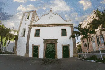
But evidence of the past remains in the austere architecture of the colonial mansions, with their façades decorated with Portuguese tiles, and in the monumental churches that dot the landscape.
The silence of the monasteries and cloisters echoes ancient stories, while the water wheel of the mills reveals the productive cycle that has shaped the region.
The silver utensils and images of the altars bring out the cultural and spiritual richness of Bahia.
In addition, ships and caravels lie beneath the waters, bearing memories of past voyages.
The cannons of the ancient forts still watch over the horizon of the bay, bearing witness to the history that has unfolded there.
All this is woven into the mestizo memory of the people of Bahia de Todos os Santos, who carry within them the legacy of a time full of change and tradition.
2. A TREASURE TROVE OF BEAUTY AND HISTORY
Bounded at its extremities by the Barra Lighthouse and Ponta do Garcez, Todos os Santos Bay combines beauty, history and culture, reflected in its handicrafts, typical cuisine and architecture, making it a great setting for nautical tourism and ecotourism activities.
This scenery is made up of an area of calm waters 1,052 km², home to islands, beaches and the fresh waters of countless rivers and streams, the most important of which are the Paraguaçu, Jaguaripe and Subaé, as well as the first capital of Brazil and the largest in the Northeast: Salvador da Bahia, at one end.
It is surrounded by the municipalities of Itaparica, Vera Cruz, Jaguaripe, Nazaré, Salinas da Margarida, Maragogipe, São Félix, Cachoeira, Santo Amaro, Saubara, São Francisco do Conde, Madre de Deus and Candeias, among many others, which make up the Recôncavo Baiano.
In Bahia, the word Recôncavo took on a new dimension, with a capital letter, to identify the region around this bay.
In order to ensure the protection of its islands, regulate the socio-economic activities present in the area and preserve sites of great ecological importance, the Baía de Todos os Santos Environmental Protection Area was created by State Decree No. 7,595 of 5 June 1999.
The APA covers an area of approximately 800 square kilometres, including the waters of the bay and its islands, which are home to remnants of the Atlantic Forest, mangroves and sand banks, as well as a diverse flora and fauna.
3. NAUTICAL TOURISM
- History and investment in nautical tourism
- Nautical infrastructure
- Traditional competitions and regattas
- Nautical events
- Shipwrecks and hidden treasures: Exploring the depths of Todos os Santos Bay
1. History and investment in nautical tourism
In the past, Todos os Santos Bay was the largest seaport in the southern hemisphere. Today, it is the target of major public and private investment aimed at developing nautical tourism and ecotourism in the region.
2. Nautical infrastructure
A large private marina has already been built near the Lacerda Elevator, with 300 berths for boats of all sizes and modern infrastructure.
In addition, the Bahia Nautical Centre, an initiative of the State Government, not only accommodates boats, but also promotes and coordinates various nautical activities in the State.
3. Traditional Races and Regattas
Among the most popular nautical events are the traditional regattas, such as the João das Botas Sailboat Reg, atta and the famous Aratu – Maragogipe regatta. International regattas such as the Rally les Iles du Soleil and the Hong Kong Challenger are also on the programme.
In the summer, the Mar Grande – Salvador Crossing is the main competition and forms part of the Bahian Open Water Circuit with races in places such as Salinas, Itaparica, Ponta de Areia, Itacaranha, Ribeira and São Tomé de Paripe.
4. Attracting nautical events
The Bay of All Saints has a rich history, from the arrival of ships and caravels to the present day, hosting ocean-going sailing ships, luxury liners and even the yacht of Queen Elizabeth of England.
Procession of Senhor Bom Jesus dos Navegantes
The biggest and most important annual event on the waters of the bay is the Procession of Senhor Bom Jesus dos Navegantes, held on 1st January.

The Boat Gratidão do Povo takes the image of Bom Jesus on a long journey from the Cais do Porto to the Porto da Barra and then to the Igreja da Boa Viagem, accompanied by hundreds of boats.
5. Shipwrecks and hidden treasures: Exploring the depths of Todos os Santos Bay
Another unique aspect of Todos os Santos Bay is the combination of natural and historical beauty hidden beneath its waters. This scenery holds surprises for diving enthusiasts, who will come across the formation of coral reefs and the wrecks of ships that were wrecked during its colonisation.
It’s good to know that in front of Porto da Barra, at a depth of 12 metres and with a visibility of 10 to 15 metres, there are beautiful coral reefs. For experienced divers, the Outer Corals or “Parede” are in the middle of the Bay, between Itaparica and Salvador.
The walls, one mile from Salvador, are between 25 and 45 metres deep and visibility varies between 15 and 20 metres at high tide.
The coral formations and reefs near the tidal islands have a maximum depth of 11 metres and horizontal visibility of up to 15 metres.
In front of the Pier, on the North Breakwater, there is an interesting site for night dives with lots of marine life. Off the Aratuba beach in Itaparica, the Pontinha and Caramunhãs coral reefs, two miles off the coast, offer a rich underwater landscape.
The ghosts of history have also become a target for divers in search of treasure, research or curiosity.
Between battles, invasions and storms, several ships have sunk in Todos os Santos Bay, and the best known and historically recorded are:
- The ship Nossa Senhora de Jesus, 1610 – attacked by Dutchmen from the Companhia das Índias, sank off the Fort of Santo Antônio da Barra, at the entrance to the bay;
- Seven Portuguese ships, 1624, were set on fire and sank off the slope of what is now Avenida Contorno;
- Two Flemish and one Lusitanian ships, 1627 – went to the bottom of the sea at Preguiça beach during a battle between the Portuguese and the Dutch for possession of the city of Salvador;
- Two Dutch and one Portuguese ship, 1647, sank after another sea battle near Fort Monte Serrat;
- The ship Santa Escolástica, 1648 – sank on its way out of the bay;
- The galleon Nossa Senhora do Bom Sucesso, 1700 – sank off Preguiça beach;
- Spanish galleon San Pedro, 1714 – sunk in the same place;
- The galleon Our Lady of the Rosary, 1737 – sank at Monte Serrat, laden with jewellery, gold, porcelain, amber and pepper;
- The wreck of the ship Bretanha, known as the “Navio de Dentro”, is near Farol da Barra, protected by coral reefs and an ideal place for first dives.
4. ECOTURISM
The verb conjugate is always present when talking about the Baía de Todos os Santos: combining sea and land, old and new, legends and history. This is how the ecotourist’s “discovery” gaze comes across the possibilities of visiting its islands and the Recôncavo Baiano region, where the traces of Portuguese colonisation and the mixing of European, African and indigenous cultures are strong.
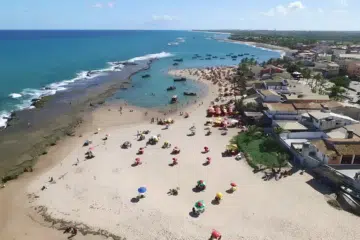
The 56 islands that make up the Baía de Todos os Santos archipelago share common characteristics such as beaches with crystal clear waters, calm seas, dense vegetation, predominantly mangroves, coconut and banana plantations, and traces of the Atlantic Rainforest.
The main islands of Todos os Santos Bay are Itaparica Island, the largest island in the bay, known for its calm beaches and reefs; Frades Island, famous for its crystal clear beaches and natural pools; Maré Island, a popular destination for its quiet beaches and exuberant nature; Cajaíba Island; Bimbarras Island; Vacas Island; Canas Island; Bom Jesus Island; and Ilha do Medo.
Bahia’s Recôncavo, rich in folklore, cuisine and the arts of its black people, shows traces of its past in the historic towns and nearly 400 old sugar mills that populated the region during the colonisation of Brazil.
It hides a past of riches and heroic deeds of its people who, practically unarmed, fought against foreign invasions and sugar mill owners united in support of D.Pedro I, who bravely fought back against Pedro I, who bravely fought against the Portuguese for Brazil’s independence.
To visit the Recôncavo Baiano is to be dazzled by the baroque 18th century architecture in towns such as Cachoeira, São Félix, Santo Amaro, Jaguaripe and Nazaré, which were born, developed and experienced luxury and opulence during the sugar cane, tobacco and cattle cycles.
With the abolition of slavery in Brazil, the economy of the Recôncavo collapsed and the mill owners went bankrupt.
The large house families moved to the provincial capital, leaving behind villages, towns, beautiful colonial buildings and the massapé lands. A world of memories that have crumbled with time.
It’s also to enjoy the typical cuisine, which combines the influences of the three races in dishes flavoured with palm oil and a wide variety of sweets, liqueurs and brandies; is to discover the natural beauty hidden in the Paraguaçu and Jaguaripe rivers, in the area of their estuaries, in the Bay of All Saints, in the Iguape Lagoon, on the Beaches of Saubara.
Religiosity, Mysticism and History are the hallmarks of the Recôncavo, which is surrounded by extensive sugar cane plantations, rich mangrove forests and remnants of the tropical rainforest.
History and tourism in Todos os Santos Bay
Publicações Relacionadas
Bahia Pantanal: A Hidden Ecological Gem
Itaparica Island: A Gem in the Bay of All Saints
Ilha do Medo: Mistérios e Assombrações
Main islands of Todos os Santos Bay
History of the island of Itaparica in the Bay of All Saints
City of Cachoeira: Bahia's Hidden Historical Treasure
Santo Amaro in the Recôncavo Baiano and its history
History and characteristics of Todos os Santos Bay
Discover the beauty and diversity of the Bay of All Saints
Madre de Deus: a paradise in the Recôncavo Baiano
Ilha dos Frades - History, Beaches and Attractions
Documentary about Itaparica Island na Bahia
Ilha de Maré: The beauty of Todos os Santos Bay
Tourist information about Bom Jesus dos Passos Island
Tourism in São Francisco do Conde (BA) — Tips and Attractions
Candeias: History of the Feast of Our Lady
Salinas da Margarida (BA) — Beaches, Attractions and a Complete Guide
This post is also on:
![]() Português
Português ![]() English
English ![]() Deutsch
Deutsch ![]() Español
Español ![]() Français
Français