Este post também está disponível em:
![]() Português
Português ![]() English
English

The construction of forts and lighthouses was due to the need to protect the city of Salvador and that the first colonizing objective of the Portuguese was to ensure sovereignty over the discovered territory.
The choice of the site for the installation of the city of Salvador also took into account religious aspects.
“The higher a city was built, the closer it would be to God and his protection”, said someone at the time.
Strategically, the choice of the high mountain proved to be convenient to the military model then dominant in Portugal, since the plateau was located in the inner part of the Baia de Todos os Santos and this was a good anchorage to shelter the ships.

Cithin this spatial context, a defense structure was set up in the most strategic locations.
Anyone who knows Salvador has to admit that the choice was right.
Where could more forts be built than those that have been constructed? Perhaps one on the island of Itaparica, for sure! Outside Salvador!
As the city grew beyond the original walls, this system proved weak and ineffective, so much so that the Dutch and French bombarded and took it with great ease.
However, this weakness and ineffectiveness was not due to the location of the forts, which in our view was perfect.
The problem lay in the extent of access by sea, open and vast, which made it difficult to defend properly, since the firepower of the fortifications was low.
Videos about the Forts and Lighthouses of Salvador da Bahia
Forte São Diogo e Forte Santa Maria
Forte Nossa Senhora de Mont Serrat- Ponta do Humaitá
História dos Fortes de Salvador da Bahia
Por que o Farol da Barra foi construído?08:50

Farol de Itapuã - Drone
Ponta de Humaitá e Forte São Marcelo - Drone03:57
The Ponta do Humaitá in Salvador is one of the most beautiful places in Salvador.
The ships coming from the south, for example, passing close to Itaparica Island, were totally immune to the batteries of the Salvador forts.
Let us look at a summary of the interview given to a press organization by Colonel Anésio Ferreira Leite, President of the Brazilian Association of Friends of Military Fortifications and Historic Sites (ABRAF):
Salvador once had more than 30 fortifications. Today there are only 11 left. We are throwing away our references and our roots.
The first fort erected was that of Santo Antônio da Barra in 1534, also known as Farol da Barra today.
In 1696 when it received the lighthouse, it was renamed Vigia da Barra”.
In 1650 was erected the Fort of St. Marcellus, also known as Fort of the Sea.
Still in Barra, there are the forts Santa Maria and São Diogo erected between the years 1624 and 1638. Going up to Campo Grande are the forts São Pedro and São Paulo da Gamboa, both built by the Dutch.
The Fort of São Paulo da Gamboa had the largest cannon in the city, weighing 13 tons.
This equipment was moved to the front of the 6th Military Region Headquarters, in Mouraria.
At the entrance to the São Joaquim Maritime Terminal is the Santo Alberto Fort or Forte da Lagartixa, so called because it had small cannons that could be moved everywhere.
In the neighborhood of Santo Antônio is located the Fort of Santo Antônio Além do Carmo. Why “Além do Carmo?
Everything that was built after the north gate was known as “Além do Carmo”. The largest fortification in Salvador is the Fort of Nossa Senhora do Monte do Carmo or, simply, Forte do Barbalho”.
History of the Forts of Salvador de Bahia
The city of Salvador was born under the sign of defense, since the first colonizing objective of the Portuguese was to ensure sovereignty over the discovered territory
The Forts were the main elements of the defense system of the colonial capital of Brazil. The old trenches, bastions and towers that occupied strategic places of defense gained walls and cannon batteries.
Some of the designs were the brainchild of the Portuguese military, while others were drawn up by military engineers from the Italian and French schools, hired by the colonial government, and show the use of the natural conditions of the land, not only for defense needs, but also for the exercise of the most beautiful plasticity.
When the first Governor-General, Tomé de Souza, arrived in the old town of Porto da Barra in 1549, the site for the headquarters of the Portuguese colonial administration had already been chosen.
Following orders from King João III, Tomé de Souza built the fortress town on the highest and most protected site, surrounded by almost impassable swamps and overlooking the entire Bay of All Saints.
The Portuguese began the implementation of a defense system that would evolve until the 18th century.
The first military defense built was a large rampart of mud and clay, sufficient against the arrows of the Indians.
Later, the wall was enlarged and reinforced with stone and lime, gaining bastions on the side facing the sea (through which the corsairs approached) and towers encased in the gates facing São Bento and Carmo.
In the 17th century, the old wall gave way to an efficient system of defense in depth, with trenches, ramparts and fortifications, built in strategic places and armed according to the evolution of the art of war.
At the beginning of the 17th century, the threat of a major foreign invasion led to an increase in the number of fortified positions in Salvador.
At the time, the line of defense, formed by the Forts of Santo Antônio da Barra, do Mar (today São Marcelo), Santo Alberto, Nossa Senhora do Mont Serrat and Itapagipe, and the battery of fortifications of Ribeira das Naus, was already structured enough to impress the invaders.
In 1624, this defense system organized a heroic resistance against the Dutch, but was defeated by the great superiority of the enemy.
With the reconquest of Salvador by the Portuguese and Spanish a year later, the defense system was resumed and new Forts built, while others were restored and enlarged.
This allowed the city to repel, in 1638, the new attack of the powerful Dutch armada under the command of Prince Maurício de Nassau (who had already taken Recife); this victory broke the myth of Dutch invincibility and gave birth to the mystique of the Indomitable Salvador.
1. Chronology of the Construction of the Forts of Salvador
From the End of the 16th Century to the Dutch Invasion
- The Tower of St. Albert
- Forte de Santo Antônio da Barra
- Monserrate Fort
- Lizard Fort
The Fortifications After 1625
- The Defenses of Porto da Barra – Forts of Santa Maria and São Diogo
- The Fort of the Sea or Our Lady of Pópulo and St. Marcellus
The Fortresses of the 18th Century
- Forte de São Pedro
- Bateria de São Paulo da Gamboa
- Forte de Santo Antônio
- Além-do-Carmo
- Forte do Barbalho
- Jiquitaia Fort
- Disappearing Chandeliers
2. Forts and Lighthouses of Salvador de Bahia
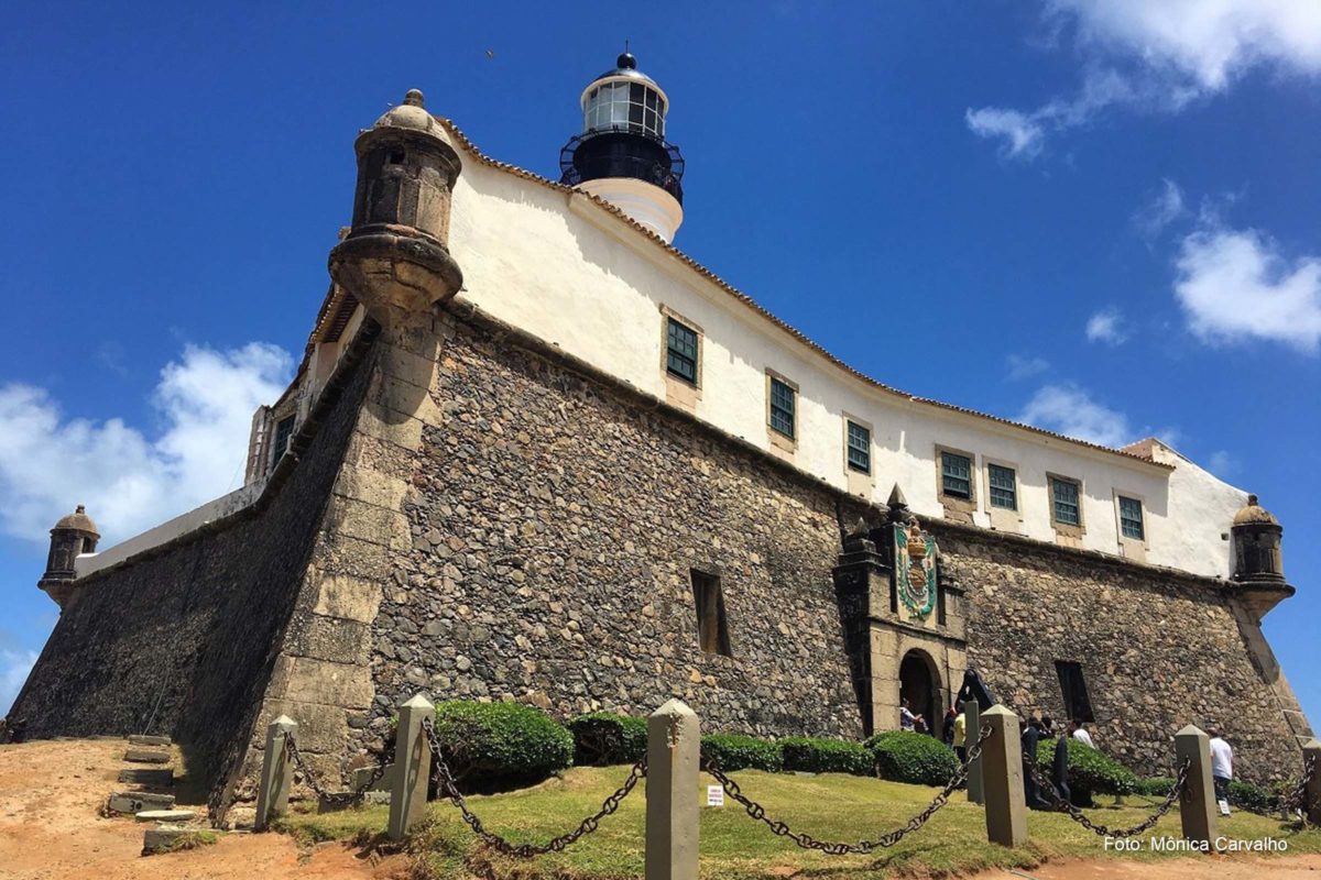
2.1. Barra Lighthouse or Fort of Santo Antônio da Barra

Barra Beach, Oceanic Avenue
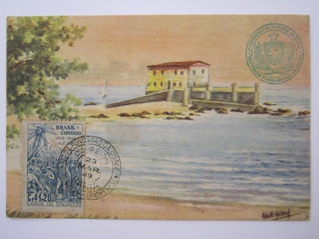
The Fort of Santo Antônio da Barra, popularly called Farol da Barra.
Located at the tip of the border between the Atlantic coast and the inlet of Todos os Santos Bay (former Ponta do Padrão), the Forte de Santo Antonio da Barra provides a beautiful view of the ocean and it is impossible to remain indifferent to its grandeur and elegance of its layout. This is the oldest military building in Brazil (1534), the original lighthouse was installed in 1698 at a height of 37 meters from sea level, and was the first lighthouse in the Americas.
Between the 17th and 18th centuries, the fort was given the irregular shape of a star, with four re-entrant faces and six protruding ones.
The fort was built in the 17th and 18th centuries.
This was the new line of Portuguese military architecture. Whale oil powered lamps that signaled to sailors the entrance to the bay.

Renovations transformed the lighthouse in 1839, 1890 and 1937, when it was electrified and the kerosene incandescent installation was removed. Today the luminous range is 70 km for white light and 63 km for red light.
Due to the strong Catholic inclination, which Brazil used to live with the presence of the Church, a super interesting curiosity of the fort is the adoption as the first patron saint of Salvador and the military rank, in the grade of soldier, granted to the image of Saint Anthony.
The saint, that is, his image, won promotions and corresponding salaries for centuries, and only had his salary revoked in 1912, when he already held the rank of lieutenant colonel.
One of the landmarks of the coast of Salvador and the main postcard of Praia da Barra. Built between 1583 and 1587, it is part of Fort Santo Antonio da Barra and houses the Nautical Museum.
In 1501, during the first exploratory expedition to Lusitanian America, the Portuguese landed in Barra, negotiated with the Indians and installed their standard of possession on the site. It was All Saints’ Day and they baptized the great bay with that name.
This place, which marks the entrance to the Bay of All Saints, became known as Ponta do Padrão and later Ponta de Santo Antônio.
História do Forte de Santo Antônio da Barra em Salvador
In it, the Fort of Santo Antônio da Barra was built (16th century) and, inside, a lighthouse (17th century).
The Fort of Santo Antônio da Barra, was the first in Brazil, had its first building around 1536, carried out by the grantee of the Captaincy of Bahia, Francisco Pereira Coutinho. Between 1583 and 1587, it was renovated and expanded.
Between 1596 and 1602, the fort was rebuilt in stone and lime as an octagonal tower. This project is attributed to the chief engineer of Portugal, the Cremonese Leonardo Torriani.
")
In addition to the lighthouse, the fort’s attractions include the Bahia Nautical Museum and a café. The climb to the lighthouse tower has a quiet 94 steps and is quite nice; the top allows panoramic views of Barra and the sea and it is possible to see up close the centenary machinery of the lighthouse lighting system.
Wreck of the galleon Santíssimo Sacramento that caused the FAROL DA BARRA to be built
The galleon Santíssimo Sacramento, had left the Tagus as captain of the escort of a fleet of 50 merchant vessels of the Companhia Geral do Comércio do Brasil and which brought João Corrêa da Silva, to be sworn in in the government of Bahia, also leading tin and copper to the shipyard of Salvador, was shipwrecked, during a storm, on May 5, 1668.
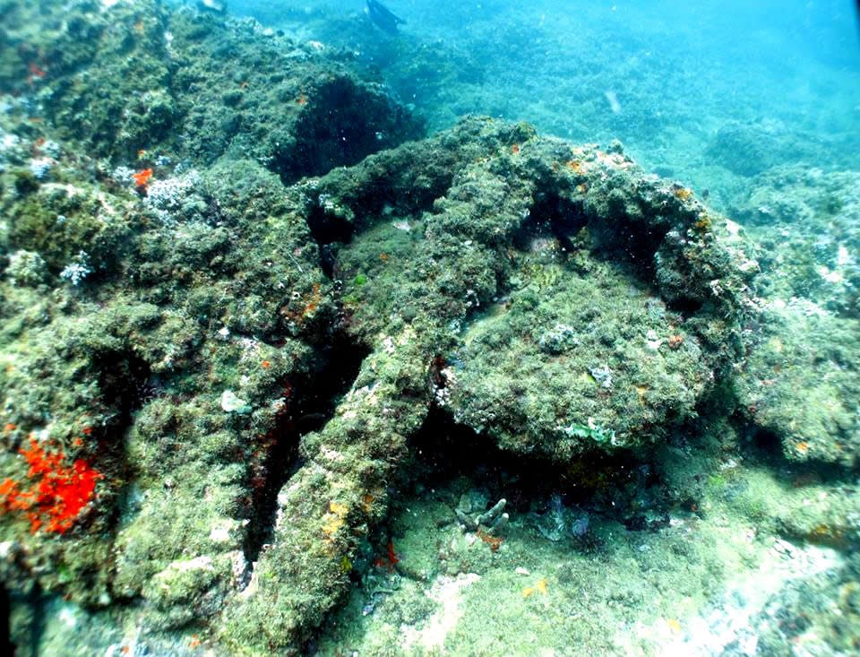
Naufrágio do galeão Santíssimo Sacramento em 1668
The galleon having arrived near Salvador, and in the presence of strong winds from the south, it could not enter Bahia by the normal route and ended up crashing into the bank of Santo Antonio, remaining for some hours adrift and finally sinking during the night (at approximately 23:00 hours).
The acting governor, Alexandre de Sousa Freire, sent as soon as he was informed of the accident as many fast boats and skilled navigators as were in Ribeira, but because, for the time, the distance to be traveled was great, they only arrived at the place with the break of day.
“They found the ship in pieces, and a large number of bodies, some still alive, wandering through the seas, others already lying dead in the sands …, and only a few people saved their lives, to which he put his fortune and the diligence of the fishermen of those beaches …, and a few who on the boards piously shattered in their remedy were put ashore.” (ROCHA PITA, Sebastião, História da América Portuguesa – Lisbon, 1730).
There are disagreements as to the number of people who were embarked on the Sacramento, some cite 800, others 400. It is known that only about 70 people were saved.
After 3 centuries submerged, its hull was located, at 13º 02′ 18″ S and 30º 30′ 14″ W, by fishermen who were looking for the reason why their nets were stuck to the bottom. What was left of the Sacramento lay at a depth of 15 meters near a steep slope.
The hull later slid down this slope to a depth of 25 to 30 meters.
See also History of the Foundation of Salvador da Bahia , Historical Center of Salvador
and History of Santo Antônio da Barra Fort in Salvador
2.2. Itapuã Lighthouse

Striped in red and black, the lighthouse that inspires verses and songs. Former reference for boats passing by the coast, today it is a poetic and bucolic landmark for all who just want to spend an afternoon in Itapuã.
Built in 1873, by the engineer Zózimo Barroso, with his own resources, to signalize sand banks in the area and guide maritime navigation in Salvador, this lighthouse is 23 km away from Farol da Barra.
Its cast-iron tower is 21 m high, sits on a concrete base and is connected to the beach by a bridge, also made of concrete.
Originally painted earthy purple, since 1950 it has kept the horizontal stripes painted in red and white.
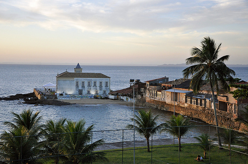
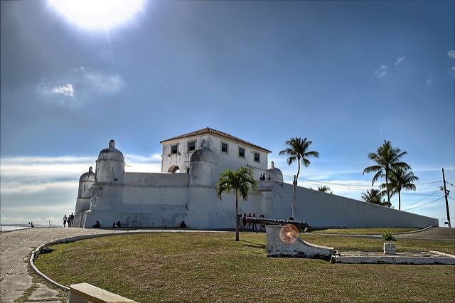
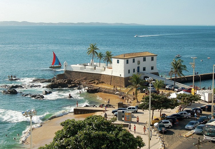
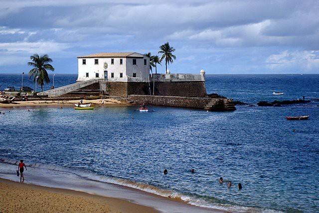
2.3. Nossa Senhora de Mont Serrat Fort or Monserrate

Ponta de Humaitá
Built in a cove on the then northern edge of Salvador, between 1583 and 1587, the Nossa Senhora de Mont Serrat Fort succeeded the primitive Fort of St. Philip, shaped like an irregular hexagon with circular turrets at the angles, covered by domes. A drawbridge between the ramp and the terrace configured the primitive fort, and on the first floor, two barracks surrounded the entrance.
In May 1624, the fort was involved in the clashes inherent in the invasion of Bahia and prevented the Dutch from landing, but was eventually taken by the enemy in a new attack on the city.
The Governor-General, Diogo de Mendonça Furtado, was imprisoned and the capital of the State of Brazil conquered and a new government established by the Dutch nobleman Johan Van Dorth. In front of the fort, there is a plaque reminding visitors: “On July 17 / 1624 was / killed in this / place the Dutch gene / ral / João van Dorth).

The Monte Serrat Fort has significant historical importance, with indirect participation in the Sabinada and the Christie Question in the 19th century.
There is even a record that, in 1859, the fort was visited by Emperor Pedro II of Brazil, who recorded in his travel diary: “October 28 (…) I went to the fort of Monserrate which lies abandoned, the inscription that existed on the gate having been chopped. It has a beautiful view and [engineer André] Przewodowski, who lives nearby, said that no one has died there yet of yellow fever or cholera.”

This fort is another of Salvador’s very special treasures. An example of military architecture abaluartado (= “Italian layout”, “fortification in star” or “fortification to the modern”), being considered the oldest Brazilian fortification with original configuration and one of the best military works of Colonial Brazil.
With simple installations, in the fort there are several paintings about the Defensive System of Salvador, the Dutch invasion in Bahia, historical flags of Brazil, etc. A real historical breath.
It began to be built in 1583 and, until its completion in 1742, was the scene of Dutch struggles and resistance. Today, it houses the Armada Museum, with various military objects and armaments.
The view to the Baia de Todos os Santos and the Itaparica Island is an extra chapter. It is open from Tuesday to Sunday, from 9am to 12pm and from 1:30pm to 5pm.
The Fort of Nossa Senhora de Monte Serrat belonged to the Army and, today, is seen by many as the most beautiful military construction of the Brazilian colonial period.
It began to be built in 1583, in a strategic position on top of the most advanced tip of the peninsula and with views over the city’s port.
História do Forte de Nossa Senhora de Monte Serrat
Completed in 1742, it remains as a command house flanking the round bastioned walls, boasting nine cannons.
Its history saw resistance to the Dutch and the death of the commander in 1624 by Brazilian soldiers during a visit by Governor Van Dorth to the fort.
Since 1993, it has housed the Armory Museum, with civilian and military armaments, light and medium, some used by the Army in the past.
From there, the view of the entrance to the Bay of All Saints is privileged, seeing on one side Salvador and on the other, the Island of Itaparica.
History of the Fort of Nossa Senhora de Monserrate
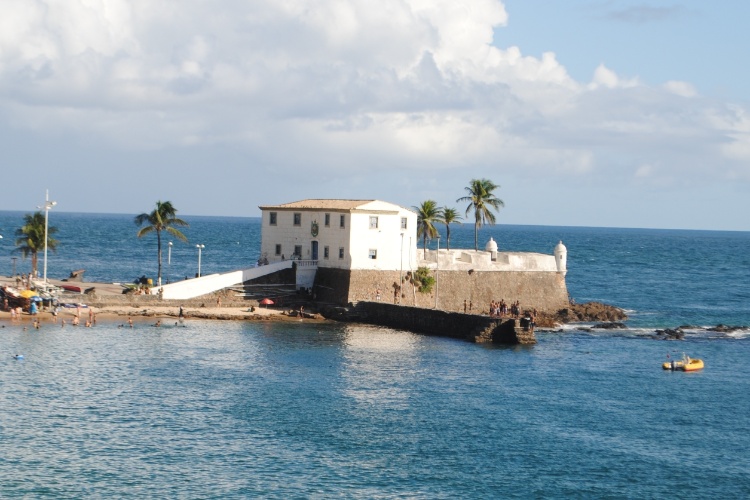
2.4. Fort Santa Maria

Porto da Barra Beach
The fort of Italian architecture was built before the Dutch invasion, being one of the oldest architectural constructions of the city
The cannons are still there, aiming at possible invaders coming from the sea. In the building there is an old gunpowder room.
The Fort of Santa Maria, in Porto da Barra, was built in 1614, with a project by the chief engineer and director of fortification works in Brazil, Francisco de Frias da Mesquita (1578 – 1645).
It was rebuilt in stone and lime masonry in 1696 to a design attributed to the engineer José Pais Esteve. The current basic structure of the fort dates from this period.
Its façade still displays the emblem of the Empire of Brazil. It was listed by IPHAN in 1938 and is administered by the Navy. Since May 2016, it has housed the Pierre Verger Space of Bahian Photography.

Today, the Fort of Santa Maria houses the Pierre Verger Space of Bahian Photography and has an open space where you can appreciate other angles of the Bay of All Saints. Small, delicate, graceful, this is one of Salvador’s many priceless treasures.
Video about the Fort of Santa Maria that expelled the Dutch from Brazil
Forte de Santa Maria expulsou os Holandeses do Brasil04:09
História do Forte de Santa Maria em Salvador - BA28:03
2.5. São Diogo Fort

Fort of São Diogo – Salvador da Bahia – Base of Morro de Santo Antonio
The seizure of Salvador, then capital of Brazil, by the Dutch in 1624, demonstrated the fragility of the city’s defense. Portugal, and consequently Brazil, was under the rule of Spain (the so-called Iberian Union). Felipe IV, king of that country, personal enemy of the Dutch, then mobilized a huge flotilla of war that managed to retake the city, a year later.
Not giving up, the Dutch carried out successive attacks to retake the “head” of Brazil.
In an effort to avoid this, Spain implemented a defense system, providing the city with fortifications, distributed along the Bay of All Saints, Barra and Itapagipe.
The Dutch were not satisfied with their attacks.
In a short space of time, dozens of forts formed a veritable cordon of fire, making Salvador the most protected city in the Americas. After these forts, the city was never invaded again.
The Forte de São Diogo emerged just in this context. It was built between 1626 and 1635, after the expulsion of the Dutch invaders (1624-1625).

Its position on the ground and battery of cannons inhibited a new foreign incursion into Porto da Barra in 1638, as it formed a defense system in conjunction with the Fort of Santa Maria. Its current curvilinear layout took shape in the early 18th century.
Today an important cultural center of Salvador, it was built in the early 17th century to defend the southern entrance to the city.
Renovated after the Dutch invasion in 1624, the fort had its works completed in 1722.

The primitive Fort of São Diogo was built between 1609 and 1613, on the slope of Morro de Santo Antônio.
História do Forte de São Diogo em Salvador BA
It stands on the old structure of the castle of Pereira Coutinho, the captaincy’s grantee.
The project of that time was designed by the chief engineer Francisco de Frias da Mesquita (1578-1645).
It was rebuilt in 1626. It underwent alterations from 1704 to 1722 and is the current basic structure. Further renovations took place at the end of the 19th century.
Since May 2016, it houses the Carybé Arts Space.
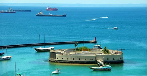
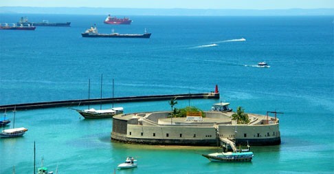
2.6. São Marcelo Fort

Inspired by the Castle of Saint Angelo (Italy) and the Bugio Tower (Portugal), the Forte de São Marcelo, also known as “Forte do Mar” (it was also called Forte de Nossa Senhora do Pópulo), is located on a crown of sand 300 meters from the coast of Todos os Santos Bay, in front of the heart of the Historic Center of Salvador.
Circular in shape and in Renaissance style, it was built entirely in wood in 1623 and has 2,500 m² of built area and, for safety reasons, only three hundred people can circulate in it at the same time.
The Fort of São Marcelo has been the scene of several confrontations throughout history.
In 1912, by a truculent action of the then President Hermes da Fonseca, the Fort turned its cannons to the very city it was supposed to protect and bombarded it mercilessly for about four hours, in the tragic episode known as the Bombardment of Salvador; which cost us the Palace of the Governors, the São João Theater, the old Primatial Cathedral and the Public Library.

Because it is “newer”, the fort features the imperial coat of arms mutilated by the Republic over the Gate of Arms and due to its location, beauty and originality was called by Jorge Amado as the “Umbigo da Bahia”.
Originally erected in wood on a reef, only with the Dutch invasion did it undergo renovations, becoming a solid fortress protecting the city center. It is open from Tuesday to Sunday, between 9am and 6pm.
Located in the middle of Todos-os-Santos Bay and formerly called Fort of Nossa Senhora do Pópulo and known as Forte do Mar, the Fort of São Marcelo was born as a triangular-shaped bastion, built in wood, at the beginning of the 17th century, on a reef, at the entrance to the port of Salvador.

After the Dutch invasion of 1624 it was rebuilt in stone masonry and gained its circular shape, as well as the mission to protect the center of the colonial city from foreign maritime attacks.
The Fort became an imposing military construction and was responsible for guarding the port, as well as being part of the network of fortifications that defended the largest city in the Americas from Dutch invasions, privateers and pirates.
At the end of the 18th century, it served as a prison for relapsed and undisciplined students and important historical figures, such as the leader of the Revolt of the Tailors, Cipriano Barata, and the Farroupilha general Bento Gonçalves.
The Fort of São Marcelo is opposite the pier and the Mercado Modelo.
The map represents the entrance to the City of São Salvador da Bahia de Todos os Santos (present-day city of Salvador, capital of the State of Bahia, Brazil), with captions of the main buildings and fortifications of São Salvador.
Highlight for the Fort of Santo Antônio da Barra (in the right corner of the iconography), the only construction that has the direct denomination on the map.
See History of Forte de São Marcelo or Forte do Mar in Salvador
History of the Fortresses and Defences of Salvador da Bahia
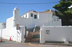
2.7. Santo Alberto Fort, São Tiago Tower or Fortim da Lagartixa
The Forte de Santo Alberto dates back to the old Torre de São Tiago and its current building dates from 1694.
The Fort of Santo Alberto dates back to 1694.
With the Brazilian victory in the War of Independence (1822-23), it is the Fort of Santo Alberto that, on 02/Jul/1823, gives the shot authorizing the embarkation of the forces to Portugal.

Removed from the sea by the expansion of the port of Salvador after World War II, it housed the Army Veterinary Service.
Contemporary to the Fort of Santo Antônio Além do Carmo, it protected the anchorage and the watering place of the vessels in Água de Meninos.
Located in front of the Ferry-Boat entrance, the Fort of Santo Alberto is almost an illustrious unknown of Salvador. Closed and overrun by cars, it is almost ostracized.
Bahia.ws is the largest tourism and travel guide for Bahia and Salvador.
History of the forts and lighthouses of Salvador da Bahia


