Este post também está disponível em:
![]() Português
Português ![]() English
English

The town of Maraú located on the side of the peninsula facing the bay, on the banks of the Maraú River, far from the beaches and tourists, the little town of Maraú maintains the same pace of life as in the past.
Difficult to reach by car, the seat of the municipality is a fishing village with welcoming people and old streets and houses that are worth a visit.
The Maraú peninsula, an extension of the wonders of the Dendê Coast, is dotted with paradisiacal corners.
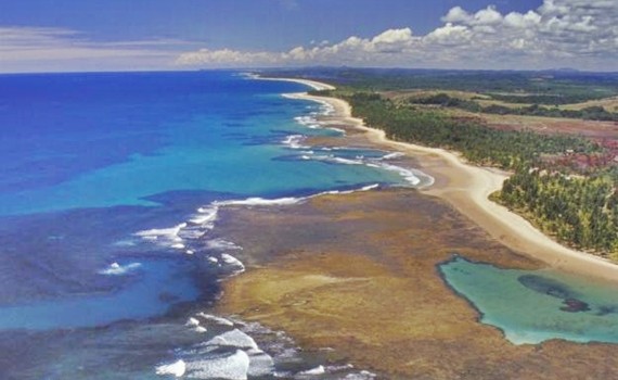
It has mangroves, dunes, waterfalls, 40 km of beaches, river lagoons and natural pools formed by coral reefs.
Inhabited mainly by fishermen, the region has as a source of additional income the production of palm oil, clove, pupunha, cocoa, guarana and black pepper. The installation of resorts has boosted tourism.
Founded by Capuchin priests in 1705, on the site of the Mayrahú Indian village, little Maraú has retained some of its old buildings.
From the viewpoint of the upper town, the view of the estuary of the Maraú River is beautiful. From there you can see the anchorage and the entire lower town.
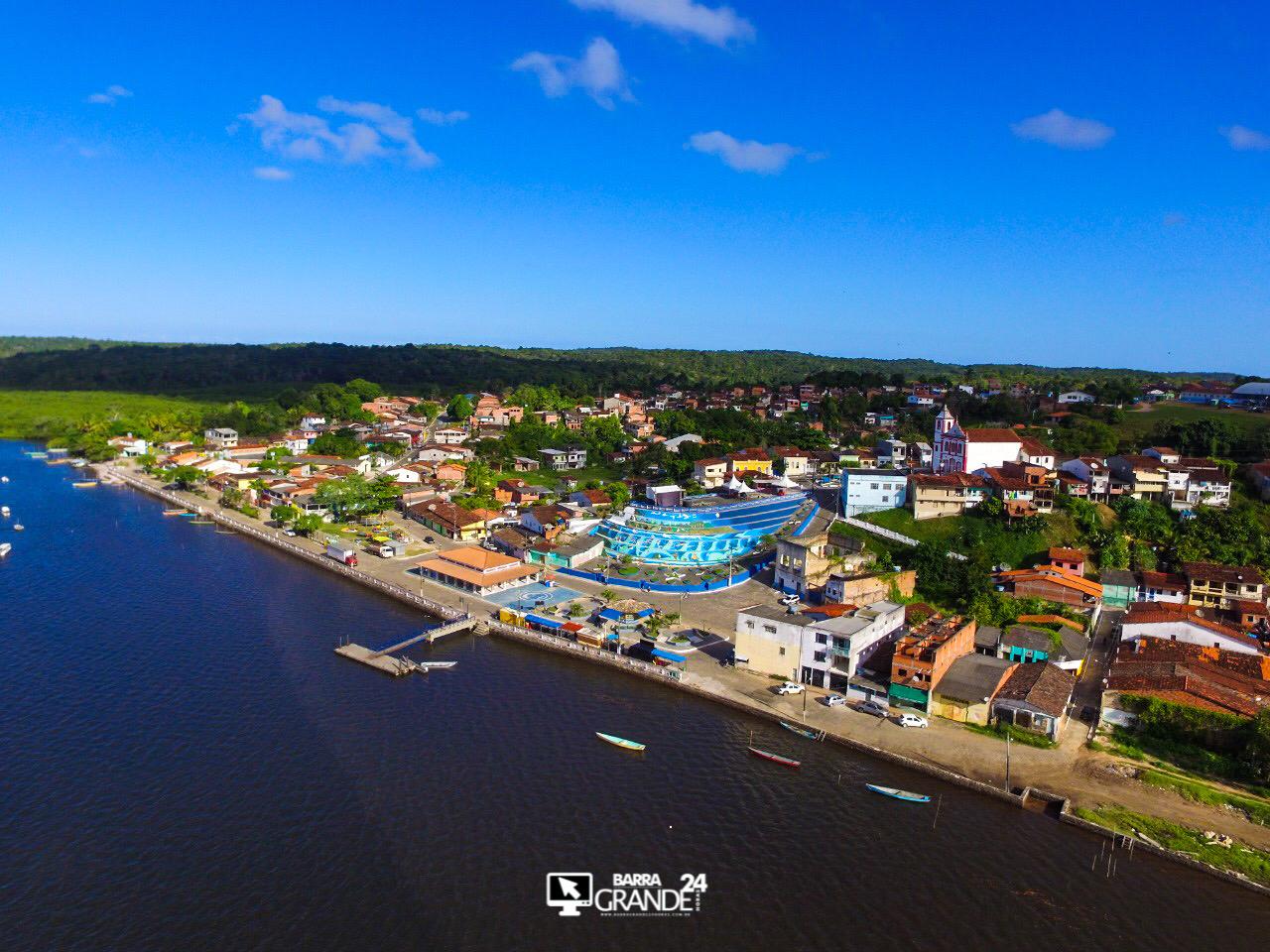
As most visitors arrive by boat, the tourist infrastructure is concentrated in the village of Barra Grande, where the port is located.

HISTORY OF MARAÚ

1705 | THE ORIGIN OF THE MUNICIPALITY
The origin of the municipality was a village of Indians called “Mayrahú”, (whose meaning in the indigenous language is: “Sunlight at dawn” discovered in 1.705 by the Italian Capuchin Friars).
The existing indigenous tribe was called “Mayra”. It is not known when they disappeared or to which branch they belonged.
By order of the Crown, the bandeirante João Gonçalves da Costa, built a road called “Estrada da Nação”.
The movement along this road contributed to the smuggling of the “Quinto de Ouro”, which gave rise to the creation of the Povoado dos Funis, where the road forked towards Camamu and the village of Barra do Rio de Contas, today the city of Itacaré.
To hinder smuggling on the road, which passed through the hinterland of the “RESSACA” farm, the city of Vitória da Conquista was built in this place. Thus Mayrahú had its “tax register”, forced by the needs of collecting the “Quinto da Coroa”.
1718 | THE DISTRICT OF MAYRAHÚ
The District of Mayrahú was created in 1718, and the Chapel built by the Friars (with Captain Major José Ribeiro Torres as benefactor), was elevated to the category of Parish, with the name of “São Sebastião de Mayrahú”, by Archbishop Dom Sebastião Monteiro da Vide, in the same year.
1756 | PEOPLE AND SITES OF THE FREQUENCY OF SÃO SEBASTIÃO DE MAYRAHÚ
In 1756, a list of the villages and sites of the parish of São Sebastião de Mayrahú was drawn up by the vicar Pedro do Espírito Santo. It states that “the seat had 26 dwellings and 1130 people of communion”.
The parish was elevated to the category of Village, by order of the Provisional Government that followed that of D. Antonio de Almeida Soares and Portugal, 3rd Count of Avintes, on June 17, 1761, being installed by the Ombudsman General of Bahia, Dr. Luiz Freire Deveras there is July 23 of the same year. On the same date, the village of Mayrahú was created.
1860 | FIRST FACTORY
In the years 1860 to 1864, the United Kingdom of England won a competition for the installation of a plant for the distillation of kerosene, extracted from peat from naphtha, and also for the extraction of oil shale in Maraú. The company was installed on the banks of the Maraú River.
The popular version is that the plant was called “John Grant”, but the farmer, finding difficulties with pronunciation, abbreviated it to “João Branco”. The João Branco mill, with all the requirements of a large refinery, cost the English Crown 600 thousand pounds sterling.
The same, employed about 500 workers, had an internal railroad, where two locomotives ran.
They say that one of them is locomotive number 12, which is in front of DETRAN, in Ilhéus. The Ilhéus Hotel, they say, was built with refractory bricks from the five chimneys of João Branco’s factory.
In that mill, where kerosene was distilled, spermaceti candles, soap, sulphuric acid and waxed paper for packaging food were manufactured and prepared for the manufacture of cellulose, in the great Industrial Park of Maraú.
The activities of the Companhia Internacional de Maraú were paralyzed. It is said that the mill stopped operating due to a strike by its staff, resulting in a succession of crimes.
The unrest reached such proportions that “Mister Grant” shot and killed a worker. He was tried for this, but even acquitted, he preferred to withdraw from Bahia, closing the factory.
The writer Maurício Vaitsman, in his book “O Petróleo no Império e na República”, says that the truth is different. The failure was “political and social”.
Today, in the town still called JOÃO BRANCO, there are the ruins of the factory and the railroad tracks.
By a paradox of fate, near the place where the great Industrial Park had been, a gypsum deposit was discovered, considered the largest in the world, by the English “trust” of Portland cement. Today, that deposit belongs to the Mauá cement group.
1938 | FROM VILLAGE TO CITY OF MARAÚ
By Decree Law No. 10,724 of March 30, 1938, the village was elevated to the category of city.
The Municipality of Maraú is located on a peninsula, called Península de Maraú, in which an APA – Environmental Protection Area was implemented, totaling a perimeter of 212 km² in an area of approximately 21,200 ha (twenty-one thousand two hundred hectares).
The municipality is rich in minerals, especially oil shale, gypsum and oil. As for the oil, it has not yet been gushed, but it is known of its existence, according to reports of renowned geologists who visited the municipality, such as Dr. Luiz Gonzaga de Campos and others of various nationalities.
The Maraú River
The city of Maraú is a great starting point to explore the Maraú River, name of the arm of Camamu Bay that extends for tens of kilometers towards the south, separating the peninsula from the mainland.
Little sought after by most tourists who prefer the beaches, the Maraú River hides beautiful landscapes, mangroves, forests and waterfalls.
Videos about Maraú city and the Maraú Peninsula
praias da Península de Maraú04:32
Península de Maraú - Reportagem
História da cidade de Maraú na Bahia25:49
See also Barra Grande and Maraú Peninsula – Tourism Guide
Tourist Spots of the Maraú Peninsula

1. Tremembé Waterfall
Going up the Maraú River you arrive at Tremembé, a small fishing village where until recently it was only possible to go by boat. With the construction of the BA-001 highway, it is now possible to go by car.
The great attraction of the place is a large waterfall that falls directly into the waters of the bay. It is worth spending a moment in the village of Tremembé and getting to know the friendliness of its inhabitants.

2. Praia do Goió

Goió Island. Straight, with weak waves, clear and loose sand, coconut trees and Atlantic Forest. It has summer houses. It is 1 hour by boat from Camamu.
3. Praia da Ilha do Campinho

With similar characteristics to the others, it has a fishing village (1h by boat from Camamu).
4. Praia de Barra Grande

Facing Camamu Bay, it is straight, with clear sand and Atlantic Forest. It has a village and some summer houses. It is 1h30 by boat (there is a regular line) from Camamu.
5. Praia dos Três Coqueiros
It is in the open sea, with coarse, yellowish sand and relatively strong waves. It has native coconut trees and some summer houses.

From there down comes a succession (40 km) of interconnected beaches, which can be covered by buggy or motorcycle (from Ponta do Mutá to Pontal). To the north there is a pousada with restaurant and camping.
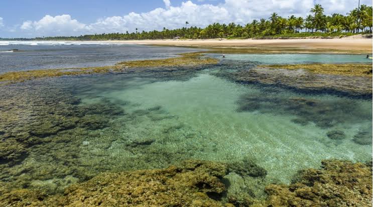
6. Praia Taipus de Fora
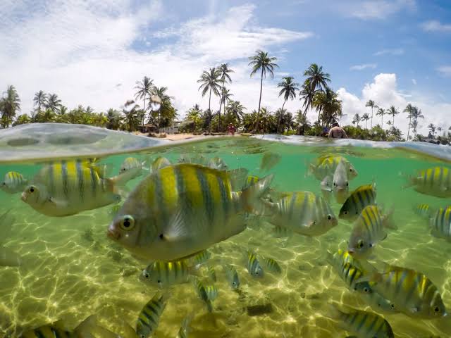
It has a large natural pool – 1km long by 500m wide surrounded by corals and full of fish.
7. Praia Cassange

The yellowish sand is softer than the others, with coconut palms and weak waves.
8. Praia de Saquaíra

Straight, with weak waves. coconut trees in the background and a village. It has inns. Nearby is the Cassange Lagoon, good for swimming and sailing sports. It can be reached by boat – 1h40 from Camamu – or by land (Ubaitaba-Maraú-Saquaíra).
9. Praia Algodões

They have yellowish sand and weak waves. In Arandi, at low tide it forms natural pools. It is possible to rent rafts.
It has slightly stronger waves than the others and yellowish sand. And the last beach of Maraú, already on the border with Itacaré.
Bahia.ws is the largest tourism and travel guide in Bahia and Salvador.
Tourism and Travel Guide of Maraú in Bahia


