Este post também está disponível em:
![]() Português
Português ![]() English
English

Itamaracá Island is an island off the coast of the state of Pernambuco in Brazil.
It is also a municipality, part of the Metropolitan Region of Recife.
It is separated from the mainland by the Santa Cruz channel.
Tourism on Itamaracá Island
About forty kilometers from Recife, the island offers tourism beaches with calm waters, coconut trees, natural pools, reefs and sandbanks. It is also sought after for the practice of water sports.
Video about Itamaracá Island


In the 17th century, Itamaracá was the scene of struggles between the Portuguese and the Dutch.
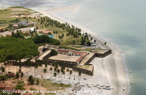
The disputes revolved around Fort Orange, built in mud in 1631 and rebuilt in stone in 1654, when it gained several cannons. A postcard of the city, the heritage spent years abandoned.

Today, it houses craft stores, a chapel and a museum.
From the walls, you can see the entire beach, as well as Coroa do Avião, a charming sandy islet with crystal clear waters and huts that function as bars.
Accessible by boat or raft, Coroa is perfect for walking, snacking and chatting.

With eleven beaches, Itamaracá offers varied options.
Some are quiet, such as Fortinho, Sossego and Pontal da Ilha; others are busy, such as Quatro Cantos, Baixa Verde, Jaguaribe and Pilar – the latter is the most popular.
In addition to the ecological reserves with remnants of the Atlantic Forest, it houses the Center for the Preservation of the Manatee.
At the southern end of the island stands Fort Orange, built by the Dutch in the context of the second of the Dutch invasions of Brazil.

Neighboring the fort is one of the oldest communities in Pernambuco, Vila Velha, today the local population earns its income mostly through tourism.
In Vila Velha, a town that emerged in the 16th century and was the administrative seat of the captaincy of Itamaracá, you can see a cluster of simple masonry houses, built near the old church of Nossa Senhora da Conceição (Rua João Paulo II, s/n), and ruins of what would have been the church of Nossa Senhora dos Pretos.

As the site is elevated, you can see the sea, the Santa Cruz channel and the Coroa do Avião.
Still to the south of the island is the islet known as Coroa do Avião, an island that is part of the municipality of Igarassu.
It consists of a sandbank that was formed by the force of sea currents and currently houses, in addition to small stalls serving regional food, the Station for Studies on Migratory Birds and Environmental Resources of the Federal University of Pernambuco, focused on the study of migratory birds.
In addition to tourist attractions, the municipality is home to three prisons: one for the mentally disabled (HCTP), one high security (PPBC) and one semi-open regime (PAISJ).
History of Itamaracá Island
The island of Itamaracá once gave its name to one of Brazil’s hereditary captaincies and was the scene of colonial disputes in the 17th century – when Dutch invaders built Fort Orange, but were eventually expelled by the Portuguese.
Today, Itamaracá is home to the Ecoparque Peixe-Boi & Cia, an important marine animal protection park and is undergoing a process of economic and tourist valorization (the three penitentiary units installed on the island are being deactivated).
The first inhabitants were shipwrecked, and there are also records of the passage of the Portuguese João Coelho da Porta da Cruz and Duarte Pacheco Pereira, in 1493 and 1498, respectively.

In 1526, there was already a chapel dedicated to Nossa Senhora da Conceição, under the responsibility of Father Francisco Garcia, in Vila Velha, located on the left bank of the Santa Cruz Canal.
The island prospered in the shadow of the sugar economy. In 1630, Vila Velha had a hundred houses and a Santa Casa de Misericórdia.
The Dutch invaded the island in 1631 and erected Fort Orange there, at the southern entrance to the Santa Cruz channel, built of rammed earth.
The fort was named after Dutch Prince Frederick Henry of Orange, uncle of Maurício de Nassau. Itamaracá Island served as a granary for the Dutch. Later, the fort was renamed Forte de Santa Cruz, already under Portuguese rule.
In 1763, King João V bought the island for the Portuguese Crown for 4,000 cruzados.
The district was created on May 1, 1866, by Provincial Law 676. The emancipation of Itamaracá Island took place in 1959, but was only effective in March 1962.
Currently, the seat of the municipality is in Pilar, elevated to the category of village in 1831.
See also – The North Coast of Pernambuco has one of the most important historical sites in the region
Geography of Itamaracá Island
Its estimated population in 2010 is 21,884 inhabitants.
The municipality is located in the geoenvironmental unit of the Northeast Coastal Lowlands, with sandbanks and mangroves. The native vegetation is composed of evergreen and restinga forest.
Itamaracá is part of the group of small coastal river basins. Its main tributaries are the Paripe and Jaguaribe rivers. The watercourses are perennial and small. It also has the Pai Tomé lagoon.
Itamaracá Island Tourism and Travel Guide in Pernambuco and Northeast Brazil


