Este post também está disponível em:
![]() Português
Português ![]() English
English

Piatã is a municipality in the state of Bahia, in Brazil.
It is the highest and coldest municipality in the state of Bahia, as well as in the entire Northeast Region of Brazil.
With 1 280 meters of altitude, surpassing other mountainous municipalities in Bahia such as: Morro do Chapéu, Rio de Contas and Vitória da Conquista.
Piatã still has higher plateau areas on the outskirts of its urban headquarters that rise up to 1500m.
Piatã is the highest mountain town in the Northeast (1180 m altitude) and the oldest settlement of the Chapada Diamantina, which is located on a plateau between the Tromba mountains – an extension of the Serra da Mantiqueira, where the sources of the Rio de Contas and Rio Machado are located – and Santana, with its chapel of Senhor do Bonfim.
The settlement began in the mid-17th century with the discovery by prospectors of mines in the Serra da Tromba and Santana, which attracted a large number of adventurers looking for gold and precious stones.
In the municipality of Minas do Rio de Contas, now Rio de Contas, the village of Bom Jesus dos Limões, now Piatã, was formed, which was born on the banks of the Estrada Real, the road opened by the sertanista Pedro Barbosa Leal, in 1725, connecting Rio de Contas to Jacobina.
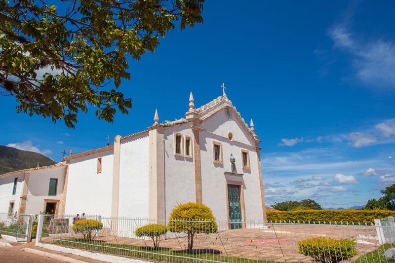
The Mother Church of Bom Jesus, located in the square Vigário Souza and the Chapel of Nossa Senhora do Rosário, dates from this period.
The June festivals are the most celebrated, both in the urban and rural areas and are characterized by the abundant table of typical products of the time and by a “cold” that can reach 3 or 4º C.

The average annual temperature never exceeds 20º C.
On June nights, the coldest of the year, in every home, there is always a handmade liquor and a “quentão” – typical drink of the region – or a warm coffee, planted and harvested in the backyards of the city.
The waterfalls of Patrício, Cochó, Rio de Contas, Malhada da Areia, Encontro das Águas, Gerais do Rio de Contas, Bica do Machado, Serra do Santana, Serra do Navio, Serra da Tromba and Três Morros, are among the main natural attractions of Piatã, which is 568 km from Salvador.
The name Piatã comes from the Tupi and means “firm foot”, “the fortress”.
See the map of Chapada Diamantina National Park
Video about Piatã in Chapada Diamantina
History of Piatã
Historians say that the foundation of the village of Piatã is the oldest of the Chapada Diamantina and took place from the stops of the expansionist movement of the 17th century, resulting in the penetration of the bandeirantes through the hinterlands of Rio de Contas, when they went up the river in search of precious stones and especially gold, near the mountains of Santana and Tromba where there were blacks amocambados since 1680.
At the beginning of the 17th century, with the discovery of large gold deposits near the Santana mountain range, a church with walls and portals in hewn stones was built on a plateau formed by the valleys of the two mountains (Santana and Tromba) and later around this temple a small settlement was formed.

Many were the bandeirantes who ventured into the hinterlands of the Rio de Contas and confronted the gentiles who infested the region.
Among many names of bandeirantes, we highlight Pedro Barbosa Leal, as being commissioned by the viceroy, the Count of Sabugosa, to open a path connecting Rio de Contas to Jacobina.
History also tells us that Captain Major Antônio Veloso da Silva, who was probably Portuguese, had an intense presence in the Sertões of Bahia, with orders from the Bahian Government to fight against wild Indians and escaped blacks.
In 1732 he was given the mission of going down the Rio de Contas and leading the material for the foundry that was to be built, as well as opening a better route to those mines. In 1738 the bandeirante fought a violent battle with the Indians in a certain stretch of the river, founding there a cattle ranch (today Jussiape).
It was in an uncontrolled and silent expansion, that they made arrive levas of men imbued with the ambition of wealth in the village that accentuated progress and received the name of Bom Jesus dos Limões, belonging to the municipality of Minas do Rio de Contas.

The district of Bom Jesus dos Limões was created by provincial law No. 169 of May 25, 1842, then had its territory dismembered by law No. 1813 of July 11, 1878 with the denomination of Bom Jesus do Rio de Contas.
On January 29, 1916, municipal law No. 31 approved law No. 1162 and created the district of Ipiranga (today Inúbia). On July 8, 1931 with state decree No. 7479 Bom Jesus do Rio de Contas was renamed Anchieta.
In 1934, on May 29, the state law decree No. 8940 created the district of Cabrália at the headquarters of Arraial de Cana Brava dos Gatos.
On December 31, 1943, state law decree No. 141 gave the name to the municipality and the headquarters that came to be called by the toponym of Piatã. In 1962 it lost part of its territory with the emancipation of Abaíra and Boninal.
Tourism and Travel Guide of Piatã in Chapada Diamantina
Bahia.ws is the largest tourism and travel guide of Bahia and Salvador.


