Este post também está disponível em:
![]() Português
Português ![]() English
English

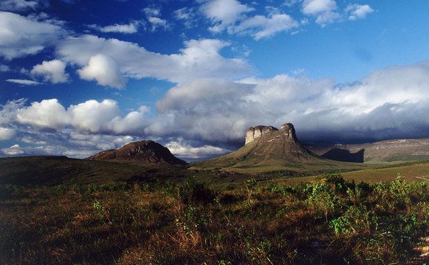
The Chapada Diamantina is a region of mountains, located in the center of the Brazilian state of Bahia, where almost all the rivers of the Paraguaçu, Jacuípe and Rio de Contas basins are born.
These streams flow from the peaks and slide down the terrain in beautiful gullies, tumbling into bubbling waterfalls and forming transparent natural pools.
The national park is managed by the Chico Mendes Institute for Biodiversity Conservation (ICMBio).
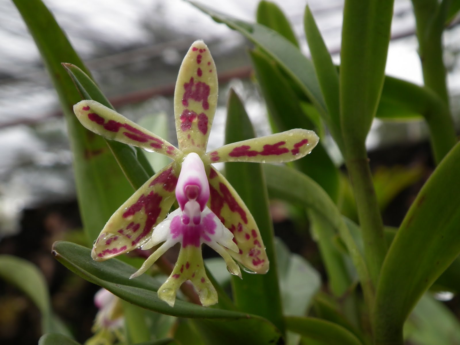
The vegetation is exuberant, composed of species of semi-arid caatinga and mountain flora, especially bromeliads, orchids and evergreens.
Some natural attractions cause amazement and ecstasy, such as the Fumaça Waterfall and its 380 meters of free fall or the stunning Poço Encantado.
But there are so many attractions that you can choose between visiting caves, bathing in waterfalls, trekking on old mining trails, riding horses or practicing sports and adventures.
The Chapada is home to esoteric and alternative communities in its valleys and peaks, such as the Vale do Capão. The two highest points of Bahia are in Chapada: Pico do Barbado with 2,033 meters (the highest in the northeast) and Pico das Almas with 1,958 meters.
See the map Chapada Diamantina
Map of the Trails and Tourist Spots of Chapada Diamantina
Walking breathing the fresh air and admiring the landscape is the main option for tourists from all over the world who visit Chapada.
The green places always hold a surprise with crystal clear waters or colored sands, beautiful hills, flowers and vegetables that enchant for their beauty and lushness.
In Igatu, curiosity is piqued amid the ruins of the ghost town, built with stones that form the walls of small caves.
Videos about Chapada Diamantina Relief, Fauna and Flora

See also Geography and Climate Regions of the Northeast
Emergence of Chapada Diamantina
The Chapada Diamantina was not always an imposing chain of mountains.
About one billion and seven hundred million years ago, the Espinhaço sedimentary basin began to form, from a series of extensive depressions that were filled with materials expelled from volcanoes, sands blown by the wind and gravels fallen from their edges.
Sediments were deposited over these depressions in a basin-like region under the influence of rivers, winds and seas.
Subsequently, a phenomenon called uplift took place, which raised the sediment layers above sea level, pressed by the epigean force, slowly rising over millions of years.
The countless layers of sandstones, conglomerates, and limestones now exposed in the Chapada Diamantina represent the primitive sedimentary deposits; the present landscape is the product of the activities of those agents over geologic time.
In the streets and sidewalks of the cities of the Chapada, slabs of undulating surfaces reveal the action of winds and waters that passed over ancient sands.
Geography of Chapada Diamantina

About 1.8 billion years ago, here, where today is sertão, was once bathed by the waters of the sea. The Chapada was covered by the ocean until a clash of tectonic plates created the deep cracks and depressions that currently make up the geology of the region.
Thus began the formation of the sedimentary mountains, through the action of winds, rivers and seas, which joined pieces of various stones and designed the local landscapes, creating the Espinhaço Basin, with elevations of very diverse shapes.
The region is geographically divided between several mountain ranges, such as the Serra de Rio de Contas, Bastião, Mangabeira, Almas and Sincorá.
They are the water dividers between the São Francisco River basin, Rio de Contas and the Paraguaçu, which flow into the Atlantic Ocean.
The Chapada Diamantina is located in the Serra do Espinhaço, which is a mountain range located on the Atlantic plateau, extending through the states of Bahia and Minas Gerais. Its terrain is Proterozoic and contains deposits of iron, manganese, bauxite, diamond and gold.
Its name was given by the German geologist Ludwig von Eschwege in the 19th century. It is responsible for the division between the drainage networks of the São Francisco River and the drainage networks of the rivers that flow directly into the Atlantic Ocean. It is considered a world biosphere reserve, as it is one of the richest regions on the planet, thanks to its great biological diversity.
The Serra do Espinhaço can be considered the only mountain range in Brazil, as it is unique in its shape and formation.
For more than a billion years in constant movement, it is a fairly long and narrow mountain range, interspersed with peaks and valleys. It is about 1,000 kilometers long, in the latitudinal direction of the Iron Quadrangle, to the north of Minas Gerais and, after a brief interruption, reaches the southern portion of Bahia.
This entire route presents a minimal difference in longitude, that is, its width varies only between 50 and 100 kilometers.
The Serra do Espinhaço was considered by Unesco on June 27, 2005 the seventh Brazilian biosphere reserve, due to its great diversity of natural resources; showing us the importance of protecting it
More than half of the endangered species of animals and plants in Minas Gerais are in the Espinhaço Chains. Especially in Serra do Cipó, where the largest number of endemic species of Brazilian flora are found.
African, European and indigenous roots are mixed in the Espinhaço, leaving their mark on the customs and cultural manifestations of the local communities. The beauty and culture of the region offer conditions for the development of ecotourism.
Among the municipalities that are cut by the Serra do Espinhaço are Porteirinha, Mato Verde, Espinosa, Olhos-d’Água in Minas Gerais and Lençóis, Mucugê, Andaraí, Iraquara, Bonito, Ibicoara, Rio de Contas and Igatu.
1. Location, Boundaries, Explanation of Boundaries and Size of Chapada Diamantina
Located in the south-central part of the biome, elongated in the N-S direction and in the shape of a “Y”, following the alignment of the Chapada Diamantina watershed.
It is entirely surrounded by the Southern Sertaneja Depression ecoregion. The boundaries are mainly explained by changes in relief, altitude and soil type. It is the highest part of the Caatinga biome.
Size: 50,610 km2.
2. Geoenvironmental Units of the ZANE
In this ecoregion are present the units of Massifs and high mountains (S2); Reworked surfaces (E4, E5, E8); Chapada Diamantina (C1, C3, C6, C8); Karst surfaces (J4).
3. Soil Types, Geomorphology, Relief and Altitude Variation
This is the highest ecoregion of the caatinga, almost all of it over 500 m altitude.
The relief is quite rugged, with large residual massifs, rocky tops, steep slopes, narrow and deep valleys, large flat altitude surfaces and high, narrow and long mountain ranges. Altitudes range from 200 to 1,800 m, with a peak (Pico do Barbado) of 2,033 m.
In the massifs and high mountains the soils are generally shallow, stony and poor, with lithic soils (shallow, stony and of low fertility) and large rock outcrops predominating. On the flat tops the soils are generally deep and very poor, with a predominance of latosols (deep, well drained, acidic and of low fertility).
A large part of the eastern Chapada Diamantina is made up of areas that have suffered intense reworking, causing a very dissected relief with deep valleys, with altitude varying from 200 to 800 m.
Podzolic soils (moderately deep, well drained, clayey texture and medium fertility) and latosols predominate in these areas.
The Chapada Diamantina contains the headwaters of several rivers that flow into the Southern Sertaneja Depression.
4. Climate
In the western part the climate ranges from hot to tropical, with an increasing gradient of precipitation from the lowest to the highest altitudes. In the lower areas the annual average is around 500 mm, while it exceeds 1,000 mm in the higher parts. The rainy season is from October to April.
In the eastern part the climate ranges from tropical to semi-arid, with a rainy season from November to May and average rainfall of 678 to 866 mm/year.
Major Characteristic Processes or Influences Altitude gradients (includes the highest points of the NE) that form “islands” of campos rupestres separated by lower valleys of caatinga – isolation process that generates speciation.
5. Temperature gradient (presents the lowest temperatures of the semi-arid)
Great influence of long dry periods, contrasting with an annual rainfall of over 1,000 mm (reaching in some years 2,000 mm – the highest rainfall in the semi-arid region) and fog formation all year round.
It shelters the sources of most of the perennial rivers of the Southern Sertaneja Depression, being the great watershed of that ecoregion.
There is influence of the Serra do Espinhaço in elements of the flora, and the presence of caves is very important for the fauna.
6. Vegetation Types
Mosaic that includes caatinga with great diversity (below 1,000 m altitude), cerrado, rupestrian fields, and different types of forest (from drier to more humid).
Above 1,000 m altitude, where there are more rocky outcrops, the rupestrian fields (linked to quartzites) predominate; where the soil is sandier, the cerrado (podzolic soil) predominates.
The forests, predominant on the slopes, are more linked to granites and gneisses, and become wetter as the altitude increases.
The forests of caatinga are of the deciduous seasonal forest type, with many thorny trees, especially of the genera Acacia and Mimosa, and abundance of Cactaceae and Bromeliaceae.
Some species are striking in the physiognomy of the vegetation, such as the umbuzeiro (Spondias tuberosa Arruda) and the juazeiro (Zizyphus joazeiro Mart.). However, there is a great diversity in the flora, and many endemic genera and species.
The caatinga occupies a large extension of the ecoregion, at altitudes of up to 1,000 m, where it intermingles with the high altitude cerrados.
The caatinga also predominates to the north, in the valleys of the Furnas River, Contas River and Paraguaçu River, as well as in the westernmost part of the mountains, where the height creates a barrier preventing the passage of rainfall.
7. Examples of Typical Taxonomic Groups
7.1. Flora
The caatingas of the Chapada have some endemic genera of the families Leguminosae, Cactaceae, Sterculiaceae, Scrophulariaceae, Martyniaceae and Compositae.
The campos rupestres harbor a completely different flora from the caatinga, but contain many species endemic to the Chapada.
Endemic genera: Rayleya (Sterculiaceae) – genus with one species, only from Andaraí; Mysanthus (Leguminosae) – genus with one species from the southern part of the Chapada; Heteranthia (Scrophulariaceae) – genus with one species from swampy areas in the east of the Chapada; Holoregmia (Martyniaceae) – genus with one species from Rio de Contas to Anajé.
Endemic species: Mimosa irrigua Barneby (Leguminosae), Chamaecrista eitenorum var. regana I. & B. (Leguminosae), Portulaca werdermanii Poelln. (Portulacaceae, from Morro do Chapéu and Mucugê), Melocactus glaucescens Buin. (Cactaceae, from Morro do Chapéu), Arrojadoa bahiensis (U. Brawn & Esteves) M. P. Taylor & Eggli (Cactaceae), Pilocarpus trachylophus Holmes (Rutaceae – occurs in MG, BA and CE).
7.2. Estimated Conservation Status
The area, which is very fragile, is threatened by coffee farming in the flat areas, by cattle ranching, and especially by mining (various types of ore) and quarrying.
Also of concern is the growing pressure of tourism of various modalities, as well as the extraction of ornamental species (orchids, evergreens, bromeliads).
7.3. Paraguaçu River in Chapada Diamantina
The Paraguaçu River, the largest river in Bahia, is formed in the Diamantina Plateau.
Its springs are diamentiferous, its banks fertile, very fishy throughout its length and navigable from the cities to its mouth. It was once the main transportation and communication route for the entire region.
The name Paraguaçu” is of Tupi origin and means “big sea”, through the junction of the terms pará (“sea”) and gûasu (“big”).
In Colonial Brazil, it was written in various ways: Paraguaçu, Paraoçu, Paraossu, Peroguaçu, Perasu, Peoassu and Peruassu. According to historians, in 1504 the French were already trafficking along the Paraguaçu River with the natives. However, its discovery is attributed to Cristóvão Jacques, commander of the first coastguard expedition that arrived in Brazil in 1526 to fight the French in the smuggling of brazilwood on the coast.
Friar Vicente do Salvador, the first Brazilian historiographer, reports that Cristóvão Jacques, on the island “dos Franceses” situated in the lower reaches of the Paraguaçu, found two French ships anchored there, trading with the natives, and sank them with equipment and goods.
It rises in Morro do Ouro, Serra do Cocal, municipality of Barra da Estiva, Chapada Diamantina, and runs northward through the municipalities of Ibicoara, Mucugê and until about 5 km downstream of the city of Andaraí, when it receives the Santo Antônio River.
It changes direction in its course to the west and east, serving as a divider between the municipalities of Itaeté, Boa Vista do Tupim, Marcionílio Souza, Itaberaba, Iaçu, Argoim, Santa Teresinha, Antônio Cardoso, Castro Alves, Santo Estevão, Cruz das Almas, Governador Mangabeira, Cabaceiras do Paraguaçu, Conceição da Feira, Muritiba de São Félix, and the cities of São Felix de Cachoeira and Maragogipe flows into the Bay of All Saints between the municipalities of Maragogipe and Saubara.
It has a course of 600 kilometers, along which it bathes important cities, including from the tourist point of view, such as those mentioned above and villages such as Santiago do Iguape, São Francisco do Paraguaçu, Nagé, Coqueiros, São Roque and Barra do Paraguaçu. It is navigable in its low course, from the mouth to the cities of Cachoeira and São Félix, passing through Maragogipe on a 46 km route.
Among the main tributaries, only those on the left bank stand out: Santo Antônio, Tupim, Capivari (São Félix), do Peixe. It forms some waterfalls, especially the Bananeiras.
The river is fished along its entire course, mainly for tucunarés, traíras and piaus, and in the lower course there are shrimps, bass and mullets.
With the construction of the Pedra do Cavalo dam, responsible for controlling its floods, it gained another use, that of responding for the water supply of the entire Recôncavo, Feira de Santana and Greater Salvador.
To get to know the Chapada Diamantina in its exuberance we propose the most diversified itinerary of the Chapada Diamantina, through which you can visit the main attractions of the National Park and its surroundings: waterfalls, caves, canyons, mountains, historical cities that are part of the Diamond and Gold cycles, as well as adventure tourism activities, for beginners and practitioners.
With a variety of short and long trails, this route is flexible to the different profiles of visitors and has quality tourist infrastructure. Listed by the National Historical and Artistic Heritage (Iphan), the cities of Lençóis, Mucugê, Igatu and Andaraí preserve the colonial houses from the end of the 19th century. The cultural diversity gives a charming atmosphere to Lençóis, which is also the gateway to Chapada Diamantina.
Bahia.ws is the largest tourism and travel guide for Bahia and Salvador.
Chapada Diamantina Tourism and Travel Guide


