Este post também está disponível em:
![]() Português
Português ![]() English
English

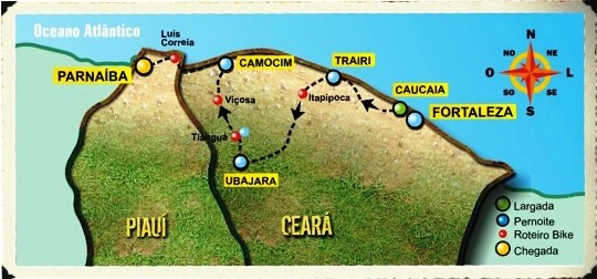
Ubajara is a municipality in the Ibiapaba mountain range or Serra de Ibiapaba and is 340 km from Fortaleza.
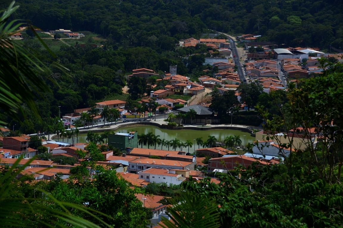
Ubajara is considered the tourism capital of the Serra da Ibiapaba, is a small town, cozy and well wooded.
The city is well signposted and has a small tourist infrastructure, consisting of hotels, inns, a cooperative (COOPTUR) Cooperativa de Trabalho e Assistência ao Turismo Ltda.
Ubajara has several natural attractions such as waterfalls, rivers, streams, caves, caves and ecological trails.
It stands out in horticulture, like the other mountain municipalities. In the service sector, its great potential is tourism.
GEOPHYSICAL ASPECTS OF IBIAPABA
The plateau of Ibiapaba, Chapada da Ibiapaba or Serra Grande, begins 40 km from the coast and goes to the western ends of the state.

It leads from Ceará to the state of Piauí. In all, the Chapada da Ibiapaba is 121 km long.
Nine cities make up the geographical framework of Ibiapaba: Viçosa do Ceará, Tianguá, Ibiapina, São Benedito, Carnaubal, Guaraciaba do Norte, Croatá, Ipu and Ubajara.
The altitude of the mountains varies between 700 and 990 m, the climate is within the range between 18 and 29 ° C.
The soil is sandy, composed of crystalline limestone with salty sedimentation. The vegetation variations are tropical pluvial, tropical pluvial – nebular and caatinga.
Almost the entire area is supplied by the Jaburu dam, which has a capacity of 220,000,000 m3. Throughout the Serra there is an abundance of fauna and flora, which makes it even more stunning.
Videos about Serra de Ibiapaba and Ubajara National Park

Viçosa no Ceará
Parque Nacional de Ubajara
Parque Nacional de Ubajara - Reportagem
Serra de Ibiapaba no Ceará
Gruta de Ubajara07:29
Ubajara - Pontos Turísticos04:15
Alguns Pontos Turísticos - Viçosa no Ceará05:42
Tianguá no Ceará04:20
Ubajara - Guia Completo05:40
ORIGIN OF THE NAME UBAJARA IN CEARÁ
The origin of the name Ubajara is indigenous, meaning “Lord of the Canoe” for some and “Canoe Mother of Water” for others.
The first version comes with the legend that an old chief, owner of a canoe that would have been the first inhabitant of the cave. Just by the name you can see the importance of water for the place.

There are other translations for Ubajara, such as “Senhor das Flechas” and “Flecheiro Exímio”. Around 1740 there was the installation of an arraial with the name of Ubajara, between the current city of Ubajara and the district of Araticum, which was extinguished after 1765 when the mining work of the cave was definitively closed.
Subsequently, around 1877, it was the turn of a village by the name of “Jacaré”, which was totally destroyed by a fire on October 8, 1884.
It was rebuilt on the right bank of the Jacaré stream and in 1890, already with a considerable population, it was elevated to the category of District.
In 1903 it was renamed Ubajara. The municipality was created in 1915, with headquarters in the then Vila de Ubajara.
Several translations were made for the toponym Ubajara, by wise historians and doctors, and all were related to the cave. Countless other forms of toponyms have also been made, such as Bayara, Ubayara, Baiara etc.
However, as all these present corruptions as to etymology, as it is the most correct, the spelling UBAJARA prevailed, which means “Lord of the Canoe”, from: Ubá canoa and Jará senhor.
Furthermore, as a complement to the etymology, historians such as Pedro Ferreira, even cited epic legends and romantic rhapsodies linked to Gruta. According to him, “this name would have arisen from the legend of a cacique who, coming from the coast, would have inhabited the Cave for many years”.
GEOGRAPHY
Its geographic space is characterized geomorphologically by the presence of rocks from the Paleozoic (Siluro Devonian) Serra Grande Group and the Ubajara Group, respectively sandstones and limestones, important for the characterization of morphological features (relief forms), mainly rocks with calcium carbonates, which form the Ubajara Cave, a highly important ecosystem for scientific tourism, located in the Ubajara National Park.

The climate of Ubajara is pleasant, with a temperature between 14º C and 30º C and as a measure of temperature 24º C can be cold, humid or temperate.
As in general the climate of the Brazilian Northeast, there are two distinct seasons, only, “winter”, the rainy, quite short and irregular; and “summer”, the dry.
The rainy season begins in late summer and becomes more important in the fall.

The rainy season occurs between January and June, concentrating about 80 to 90% of the annual rainfall total, and in the quarter with the highest volume of precipitation, February, March and April, 65% of the annual total can be registered.
From July to December there is drought.
TOURIST POINTS OF THE SMALL TOWN UBAJARA
The tourist attractions of Ubajara include:
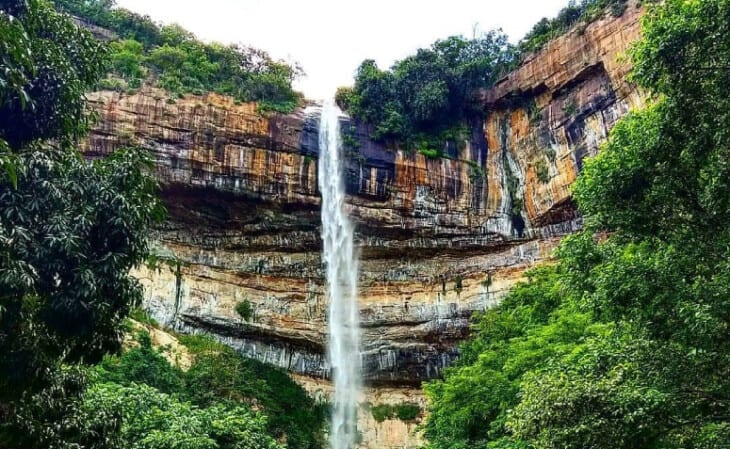
1. Boi Morto Waterfall
Located 13 km from the municipality, it is divided into two parts. Upper (spa) and lower (natural waterfalls).

2. Frade Waterfall
Located between two mountains, traveling approximately 500m, you can see a stone in the shape of a friar, hence the name of the waterfall. Environment suitable for bathing and hiking.
3. House of Major Pergentino de Souza Costa
Built in 1917, this historic house maintains the same architecture of the time and is in good condition. It is located in the city center.
4. House of Eupídio Luiz Ferreira
Built in 1928 in colonial style. The house is one of the first constructions of Ubajara, and is still all original. It is located in the city center.

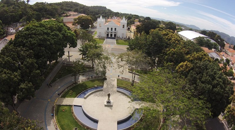
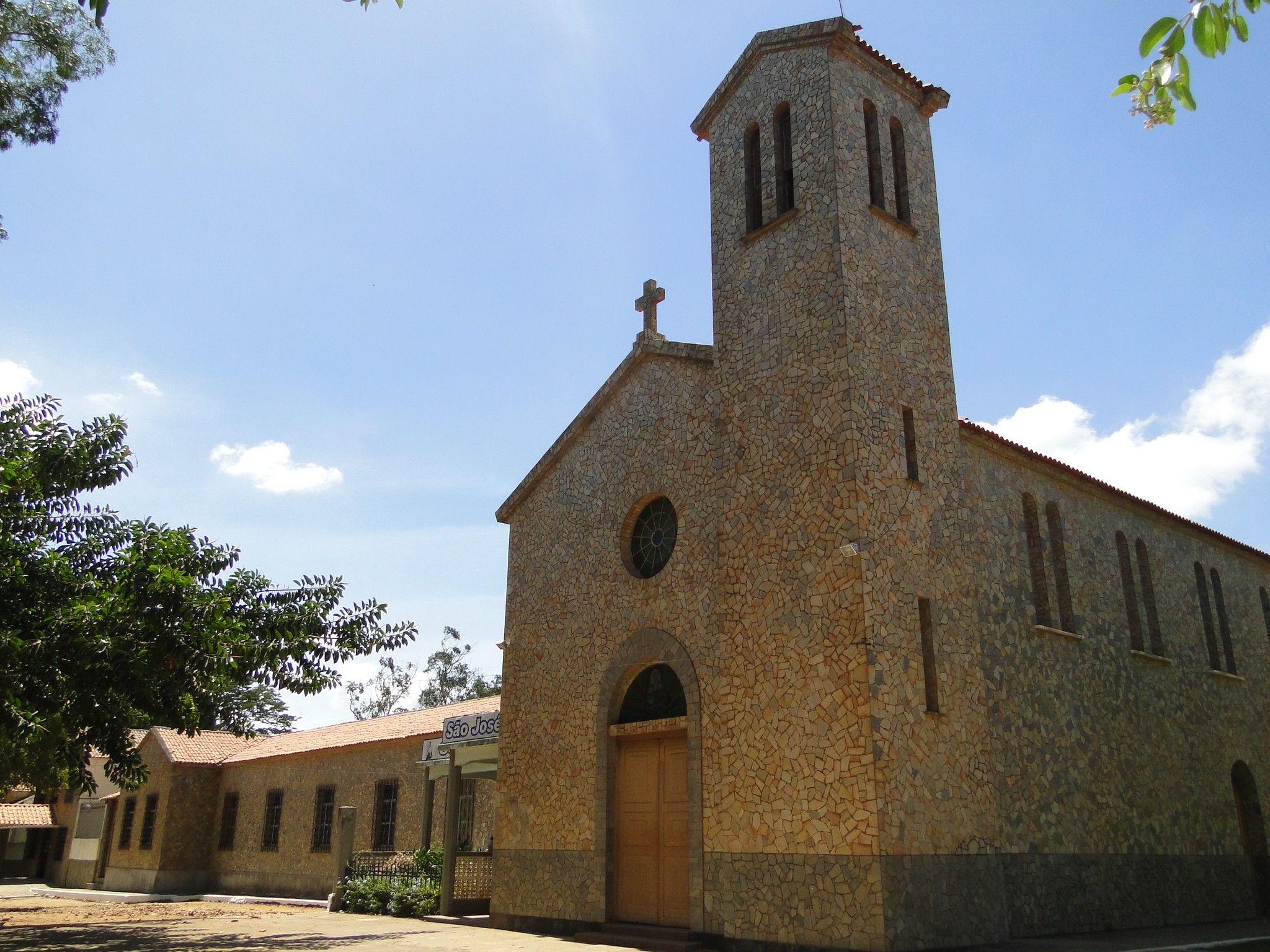
5. Mother Church – Igreja Matriz
Built in 1886. Little expressive heritage with plaster images. It is located in the city center.
6. Bica do Cafundó
Located within the Ubajara National Park, it offers an ecological tour and bathing.
UBAJARA NATIONAL PARK
The Ubajara National Park is the most important natural attraction of Ubajara, although it is the smallest among the 35 Brazilian National Parks in area, with 563 hectares.

The Ubajara National Park is located in the Serra da Ibiapaba and constitutes one of the most remarkable topographical features of the Brazilian Northeast and is administered by IBAMA.
The main objective is to protect the most important speleological heritage of Ceará.
It is the most visited tourist spot in the mountains, with exuberant landscapes and a rich biological diversity.

Tourist spots
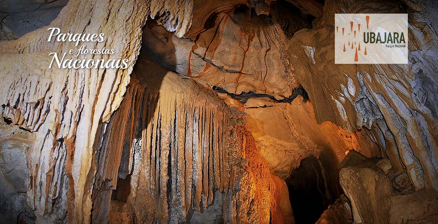
1. Ubajara Cave – Gruta de Ubajara
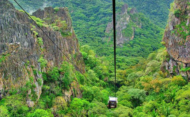
It is formed by limestone shaped by groundwater. To descend to the main mouth of the cave there are two options: take the Ubajara – Araticum trail or take the cable car that leads from the plateau to the lower part.
2. Fossil Bear Cave – Gruta do urso fóssil
Closed to public visitation, the small cave of only 130 meters is important due to the fossils of animals found inside.
3. Visitor center
Next to the Neblina Gate, it has a library and video room, as well as a permanent exhibition with photos and information about the region.
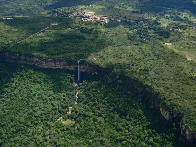
4. Gameleira Waterfall – Cachoeira Gameleira
It has a viewpoint that offers a beautiful view of the park. From it you can see the Cafundó, Gavião and Murimbeca waterfalls.
5. Cafundó Waterfall – Cachoeira Cafundó
It is located in the Bela Vista stream, a tributary of the Ubajara River. Before the largest fall, it forms a natural pool, constituting a good opportunity to cool off from the heat.
6. Rio das Minas
Name of one of the stretches of the Ubajara River, at the intersection of the Ubajara – Araticum trail. It has some wells for bathing and is located 500 meters from the mouth of the Ubajara Cave.
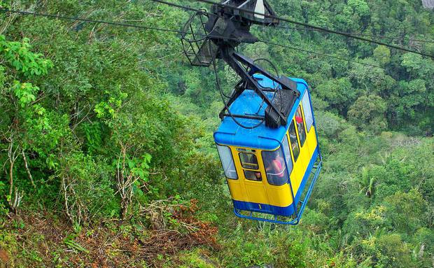
Ubajara National Park Cable Car
The cable car of the Ubajara National Park is one of the postcards of the Serra da Ibiapaba, in Ceará.
The cable car descends 550 meters. A cable car is an alternative to the almost four-hour long walk from the beginning of the park to the Ubajara cave, not to mention the grandiose view from up there.
The route to the Ubajara cave passes by the Cafundó waterfall and two viewpoints on the way, whose purpose is to appreciate the different forms of vegetation, from the caatinga to the humid forest and the varied fauna.
According to the zoning of the Ubajara cave, it is divided into three zones: extensive use zone – not open to visitation, intensive use zone – open to visitation and the intangible zone – inadmissible to any type of visitation.
Ubajara Cave
The Ubajara cave, which is one of the most important attractions of the Ubajara National Park, it should be noted that it has already undergone major changes to its structure due to internal lighting and passages for the transit of people.
The cave of Ubajara, like other caves, was formed in a limestone rock by dissolution process.
When water and carbon dioxide come into contact in the soil, they react to form carbonic acid.
As it passes through the cracks in the rock, the acid reacts with the limestone, giving rise to calcium carbonate, which is carried away by the water.
Over time, the weathering of the rock forms channels, which gradually widen to form galleries, halls and chasms. The walls become unstable and can collapse, opening up the cave even further.
In a third stage, water drips into the cave and the calcium carbon dissolved in it gives rise to the most diverse forms of cave ornamentation, speleothems.
In addition to the well-known stalactites that hang from the ceiling and stalagmites that come from the floor, there are other peculiar forms, of varying color, according to the presence of minerals, such as iron oxide. Located at 535 m altitude, rich in speleothems, the trails with walking tours, waterfalls, in addition to the cable car.
There are nine rooms in the Ubajara cave for visitation
1. Image Room – Sala da Imagem
The limestone carved by erosion has formed layers similar to a petrified waterfall or an altar where the inhabitants of the region placed an image of the Virgin of Lourdes.

2. Bell Room – Sala do Sino
An immense rocky stone, which, when struck, emits melodious sounds similar to those of bells when struck by another rock.
3. Rose Room – Sala da Rosa
With a ceiling resembling a perfect rose defoliated from above, dripping ever so slightly like droppers, forming a mortar below that gradually piles up. There are sparkles of gold and stone when meeting the light of the lamps.
4. Curtains Room – Sala das Cortinas
It received this name because it presents a magnificent spectacle on the walls, with limestone concentrations that resemble luxurious curtains of color and hues of caricature.
5. Portrait Room – Sala dos Retratos
On the ceiling, there are dark stains in the shapes of women’s portraits. One of them has the exact appearance of a caricature.
6. Indian Room – Sala do Índio
Tribes of the intrepid Tabajara nation in distant ages had once settled there. The stone, whose shapes resemble those of an Indian, looks as if it had been carved by hand.
7. Breast Room – Sala dos Seios
Saturated with beauty, there is a vast predominance of stones resembling the breasts of a woman gave rise to the room. In addition to stalactites and stalagmites that adorn it, it has the most beautiful shapes.
8. Nativity scene room – Sala do Presépio
The formation of a crib divinely made by nature, the presence of apparent biblical characters.
9. Glowing Room – Sala dos Brilhantes
The abundance of crystal stones makes it exuberant.
Mountains of Ceará or Serras do Ceará
1. Serra de Aratanha
Serra da Aratanha, also known as Serra de Pacatuba is a mountain range located in the north of Ceará, in the Metropolitan Region of Fortaleza in the municipalities of Maracanaú, Maranguape, Guaiúba and Pacatuba, 30 km from Fortaleza.
The mountain range is one of the residual massifs scattered in the Ceará hinterland depressions.
Together with the Maranguape mountain range, the Aratanha mountain range is practically an extension of the Baturité Massif.
2. Serra de Baturité
The Serra de Baturité, also known as Maciço de Baturité or Serra de Guaramiranga, is located in north-central Ceará.
It is distributed over the territory of twelve municipalities, some below the high reliefs as Canindé, Palmácia, Itapiúna, Capistrano, Caridade and Redenção.
The cities of Aratuba, Mulungu, Guaramiranga, Pacoti, Baturité and Acarape are in the mountainous regions.
The region is home to the first and largest environmental protection area in the state, covering an area of 32,690 hectares.
3. Serra de Ibiapaba
The Serra da Ibiapaba, also known as Serra Grande, Chapada da Ibiabapa and Cuesta da Ibiapaba, is a mountainous region located in the northwest of the state of Ceará.
The oldest city in the mountains is Viçosa do Ceará, which was colonized by the Jesuits of the Society of Jesus from the 16th century, has the architecture listed by IPHAN.
4. Serra de Meruoca
Serra da Meruoca is located in the municipality of Sobral, 200 km from Fortaleza. Its estimated population in 2015 is 14,674 inhabitants.
From its lands flow crystalline waters that sometimes flow through the relief in splendid waterfalls and “enchanting” waterfalls and that, for others, passes rubbing between patient and sliding granites, sculpting them.
Ubajara National Park Tourism Guide in Ceará and the Northeast of Brazil


