Este post também está disponível em:
![]() Português
Português ![]() English
English

The green landscape of the Baturité Massif in Ceará and the humid climate make the region one of the most popular destinations for weekends.
With an average temperature ranging from 20ºC to 22ºC – and minimum reaching 17ºC, the scenario has a small strip of Atlantic Forest transformed into an Environmental Protection Area, which makes the region very suitable for ecotourism.
The Baturité Massif is a geological formation located in the central hinterland of Ceará, composed of the municipalities of Pacoti, Palmácia, Guaramiranga, Mulungu Aratuba, Capistrano, Itapiúna, Baturité, Aracoiaba, Acarape, Redenção, Barreira and Ocara.
Although it covers 12 municipalities, Guaramiranga (the most famous), Pacoti, Mulungu and Baturité end upbeing the protagonists of the region.
The Maciço de Baturité is formed by limestone and granite rocks, with many waterfalls, rivers and traces of Atlantic Forest. Tourism in the region is very active, and tends to become a pole of local development, given the large flow of people, especially in the winter period.
Maciço de Baturité no Ceará
Guaramiranga no Ceará

Mosteiro dos Jesuítas em Baturité CE04:28
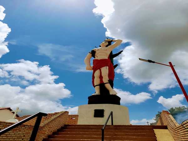
Mulungu no Ceará - Estátua de São Sebastião06:04
Many do not know, but Ceará is not just capital and beaches. Fleeing from the rush of the big cities, it is best to spend a weekend in the small towns of the Baturité Massif, which offer us peace and tranquility amidst the green of nature.
The air we breathe purifies and relaxes us. The chill we feel is very pleasant. The mountain complex is magnificent.
The Ecotourism program of Ceará is composed of 6 poles, among them, 100km from Fortaleza, the Ecotourism Pole of Serra de Baturité.
Characterized by the humid forest with specimens of the Atlantic forest, the & nbsp; Baturité Massif maintains 178 plant species, a great variety of animal species, with emphasis on 154 species of birds cataloged, only in the Environmental Protection Area – APA of Serra and Baturité.
They are lush forests, with numerous waterfalls, cascades and caves in the middle of the vegetation, with ecological trails and walls for rappelling, as well as plenty of fresh air.

About an hour from Fortaleza, the Maciço de Baturité rises up in the hinterland, with an average width of 22 km and a total area of approximately 1300 square kilometers.
Main cities of the region of the Maciço de Baturité
Baturité
Distance from Fortaleza: 106 km
Access: CE 060 / CE 356
Baturité is at the foot of the massif of the same name, formerly had great importance for the railroad that transported the horte-frute-granjeiro to Fortaleza. The massif of Baturité was an important center of coffee culture – today almost completely abandoned.
The climate attracted religious orders to the town of Baturité. Proof of this is the Jesuit monastery, a famous college of Jesuit priests, built in the 18th century and which today, deactivated, houses congresses and weekend guests.

Its origins date back to 1764, with the foundation of the Vila Real de Monte Mor o Novo d’América, organized to gather the Jenipapos and Canindés Indians under an administrative regime proposed by the Marquis of Pombal, then Prime Minister of Portugal, after the expulsion of the Jesuit missionaries from Brazil.
It had the basic structure of a typical colonial town, with a town hall, pillory and parish church. With the independence of Brazil, the town lost its archaic Portuguese name and adopted the native name of the great mountain range at the foot of which it was built: Baturité, from the Tupi Ybitiraeté, “true mountain range; mountain range par excellence”.
In 1858, when it was elevated to the category of city, it established itself as the great granary of Ceará. Synonymous with fertility, the vast mountain range that had initially given way to sugarcane plantations and mills in its valleys and wetlands, was privileged territory for the cultivation of coffee, due to its favorable climate and soil, and its quality was considered one of the best in the world, even in the 19th century.
The religious sentiment and the Jesuit heritage also deeply mark the history of the city.
Once there, be sure to visit, for example, the Fabeer Craft Beer factory, the Cristo Rei Church, the Baturité Railway Museum, the Santa Luzia Church, the Comendador Ananias Arruda Museum, the Nossa Senhora da Palma Mother Church and the Public Way of the Cross of Baturité and Image of N. Sra. de Fátima.
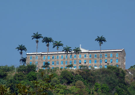
Without forgetting the Ecomuseum of Serra do Evaristo, the Monastery of the Jesuits (opening photo), the Santa Edwiges Waterfall (Parque das Cachoeiras), the Perigo Waterfall (Recanto das Cachoeiras) and the Rodeio Park.
Jesuit Monastery
The impressive stone building, erected by Portuguese Jesuits, houses objects from the former residents. There is a viewpoint 1.5 km away, on top of a hill. Access is only on foot.
The Jesuit monastery is in Baturité, 14 km away. A tip: before you go, call to find out if they are on retreat and confirm the dates of visits. For large groups, it is necessary to schedule. It is 14 km from Guaramiranga.
Guaramiranga
Distance from Fortaleza: 123km
Access: CE 060 / CE 356 / CE 065

Guaramiranga, considered the Switzerland of Ceará, is located on the massif of Baturité, at 865 meters of altitude, Guaramiranga has always been a refuge for the wealthy, attracted by the mild temperatures experienced in the mountainous region.
With an average annual temperature of 18ºC, Guaramiranga is known for its flower cultivation and also for its successful theater and jazz & blues festivals, already introduced in the city’s cultural calendar.
The city maintains 80% of its original flora, formed by species of the Atlantic Forest and Amazon Rainforest and offers visitors good hotels and inns and an excellent infrastructure of restaurants.
The region was transformed into an Environmental Protection Area (APA). An unmissable tour is to visit Pico Alto, at 1115m, one of the highest places in the state that allows visitors to have a breathtaking view of the entire region.

Until the second half of the 19th century, Guaramiranga was just a village, called Conceição, which had coffee as its main product. Since 1890 the place has been called Guaramiranga, which means Red Bird.
The smallest municipality in Ceará in territorial area is perhaps one of the best known and most famous destinations. Guaramiranga, from the Tupi “Red Bird”, became the city of flowers and festivals, hosting the tourist center of Serra de Baturité.
Its history is intertwined with the first coffee cycle in the 19th century. Originated in the Conceição site, it became a village in 1890 composing political autonomy and adopting the name Guaramiranga, denomination of the homonymous site until today existing.
After followed suppressions and restorations, Guaramiranga secured its definitive emancipation only on September 22, 1957.
From the Caminhos do Maciço, the city will offer new possibilities for visitors through the most varied cultural activities and immersion in nature, such as bird watching and bike trails, thus reviving new experiences.
I highly recommend visiting the Parque das Trilhas, the Pesqueiro, the Parque das Cachoeiras, the Convento dos Capuchinhos and its Igreja da Gruta, the Igreja Matriz de Nossa Senhora da Conceição and the Image of Nossa Senhora on the Linha da Serra path, which together with Pico Alto offer stunning views of the region. Not to mention the numerous charming restaurants scattered throughout the city.

Pacoti
Distance from Fortaleza: 130km
Access: CE 060 / CE 356 / CE 065
The city has the same characteristics as Guaramiranga: mild climate, rich in diversity of fruits and flowers. It is a true tropical paradise.
This city breathes history and still retains a simple life of a country town, also known as the “Princesinha da Serra”. Its origin was from the Pendência site that produced sugar cane and coffee, becoming a village in the second half of the 19th century.
Its emancipation took place in 1890, receiving the same name of the important river that currently crosses the city, Pacoti.

The paths of Pacoti are inviting and make it possible to know its history in a quiet and pleasant walk, where the visitor is enveloped by the sweet memory of the past and that are still present in the various attractions.
The colonial heritage is in the configuration of the public buildings that are in the Central Square, heir to the space where the agitated popular trade developed from the fair, which today takes the products to be marketed in the Public Market, full of textures, flavors, colors and aromas of typical local gastronomy (stews, pots, sweet buchadas and vegetables).
Among the attractions, it is worth mentioning the Chapel of Jesus Crucified and Cenotaph of Donaninha Arruda, the Olho D’Água Farm, the Gastronomic Village, the Maria Imaculada Institute, the Sanctuary of Nossa Senhora do Globo and the Mother Church of Nossa Senhora da Conceição.
Also on the list are the Ecomuseum of Pacoti, the Casa do Artesão, the Senador Carlos Jereissati Leisure Pole and the Sítio São Luís.
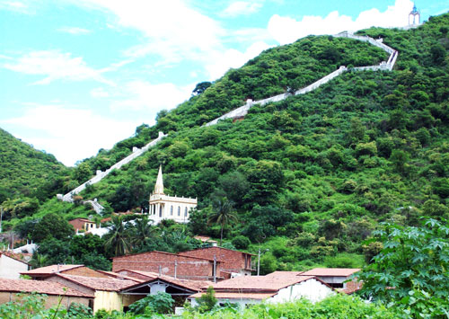
Mulungu
Distance from Fortaleza: 110km
Access: CE 004 / CE 114 / CE-065 (from which it cuts the city)
Mulungu is located in the CE-065 Microregion of the Baturité Massif in an Environmental Protection Area-APA. At an altitude of 700 meters, tropical rainy monsoon climate, temperature 21 ° C on average, annual precipitation of 1,300 mm (rainfall).
Mulungu is bordered to the North by Guaramiranga, to the South by Aratuba, to the East by Baturité and Capistrano and; to the West by Caridade and Canindé.

Its origin comes from the name of the leafy mountain trees that, according to local tradition, brought welcoming shade to the sertanejos, comboieiros and their descendants who first inhabited the settlement at the top of the Serra de Baturité.
As a place of passage, between the old road to the hinterlands of Canindé, it has beautiful landscapes and viewpoints in its breaks and steep slopes, where old families of the hinterland once climbed.
It is no coincidence that Mulungu was the stage for the first coffee-growing experience in the region: around 1824, Colonel Manuel Felipe Castelo Branco planted specimens of the precious rubiaceae in his Sítio Correntes, now Bagaço.
Seeking to overcome the challenges of the present, among them environmental preservation and a sustainable economy, it remains the largest producer of shade-grown coffee in the Serra, as well as seeking to structure its tourist services park, with good restaurants and hotels.
Among the points of interest are the Nova Holanda and São Roque sites and the Church, São Sebastião Staircase and Akhetaton Space.
Tips of the Baturité Massif
In Guaramiranga, visit Pico Alto – the second highest point in Ceará, with 1,114 meters of altitude. The place has a temperature between 12º C and 15ºC and provides visitors with a wide view of the hinterland and the sea.
At Pico Alto, take unforgettable walks among the remains of the Atlantic forest present in the region.
The road that connects the cities of Baturité, Guaramiranga and Pacoti to other cities in the vicinity is quite winding. Therefore, pay close attention when driving.
Tourism and Travel Guide of the Massif of Baturité, Guaramiranga and Pacoti


