Este post também está disponível em:
![]() Português
Português ![]() English
English
The prominence of the fortifications in the landscape of the city of Salvador certainly represents the imposition of the tactical and strategic need to position them in an elevated location with privileged visibility to the surrounding areas.
But the military engineer who designed and built them cannot be denied the aesthetic sensibility that he assimilated from the culture of his time and from the texts of the most prominent theoreticians of Renaissance and Baroque architecture.
Salvador was born as a strong city, or at least that was what King João III of Portugal intended, and while it was Salvador’s capital or the Head of Brazil, there was constant concern to defend it.
With the house sacked, the Crown of Portugal tried to reinforce the protection of its overseas capital Salvador, taking advantage of the defences left by the retreating Dutch.
One of the places chosen to garrison Salvador was the Porto da Barra, where the Batavians had landed with ease in 1624.

It is from this moment that the Forte de Santa Maria and Forte de São Diogo were born, which have since been named in the lists of fortresses in Salvador.
There is a great deal of confusion among historians about the origin of the forts, because there is no known document from the governor ordering them to be built, nor is there any Royal Order authorising their construction.
What is known is either by deduction or by record in later documents. We also find references to a trench supporting the two reduced props.

Logic leads us to place it, approximately, on the stretch of the current Avenida Sete de Setembro, opposite the Porto da Barra, once commonly known as Porto dos Holandeses.

If the efficiency of the Fortress of Ponta do Padrão or of Santo Antônio has been criticised relentlessly, the opinion of some of the critics of the small forts, of which there were many, should not be followed to the letter.
The first pronouncement against them comes from Bernardo Vieira Ravasco, who considers “they are of no use whatsoever […]”.
História do Forte de Santa Maria em Salvador - BA28:03
História do Forte de São Diogo em Salvador BA27:41
A little further on, the famous unpublished report attributed to Captain Engineer Antônio Correia Pinto, dating from around 1671, gives interesting information, including on the person responsible for the construction, a subject of controversy among historians:
“The Fortes Santa Maria and São Diogo are of stone and lime: both founded Diogo Luís de Oliveira, being Governor and Captain General of this state, at the ends of a beach that is at the mouth of the bar; from where the Dutch, and D. Fradique de Tolledo will launch the people, who surrendered, and restored this square, both are dismantled […]”.
This means that the author found some use for the forts.
Military Engineer Miguel Pereira da Costa, in 1710, did not consider them to be much good, especially the Forte de São Diogo.

As stated, one cannot have a radical position regarding the usefulness of these two “little reducers”, considering the scales and the true function they were intended to fulfil.
It is clear that Forte Santa Maria and Forte de São Diogo did not add anything to the defence of Barra, which was indefensible due to its geography, but they did make it difficult to land in a very comfortable port.
It is worth noting that when Nassau attempted to invade the city in 1638, he preferred to face the Fort of St Bartholomew in the Passage rather than risk it.
da Passagem than risk a landing on the site protected by the small fortifications.
We agree that the forts were dominated by neighbouring godowns, but they could function well as low batteries for larger fortifications occupying the eminences.

Even during the Imperial period, preparations were still made when the Christie Question prompted the defences of the Brazilian coast to be put on alert, as Colonel Beaurepaire Rohan’s report states.
It follows that the fortification experts of that time still thought that the forts in question were of some use.
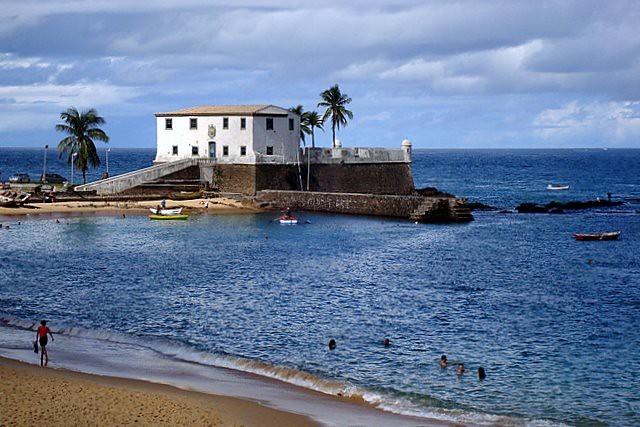
The Forte de Santa Maria rests on a small rocky promontory that bordered the left side of the cove on the site.
Its greatest firepower, due to the design conception chosen, was for flanking and covering the anchorage, demonstrating that its function had a limited and specific address.
Nowadays, it has gunboats on the parapet, but from what Luís dos Santos Vilhena describes and draws, it should have had a barbette parapet, whose sole purpose was to receive more artillery and increase the sweep of the pieces’ aim, all to the detriment of the gunners’ safety.
The words of the erudite professor of Greek and chronicler of the city of Salvador read: “not long ago, its parapets were imperfectly repaired, so that from the waist upwards the garrison is exposed to the enemy’s fire, with no other recourse than to withdraw before he fires; it has no capacity to mount more than seven to nine pieces”.
According to his fire plans, seven pieces would be a good size for the artillery.
Since the time of Vilhena, the Forte de Santa Maria has retained a detail not common in other fortresses in Salvador: a firing stand for the musketeers who defended the curtains. It had a wooden drawbridge, which was replaced by a fixed one – initially made of the same material and later of masonry.
The historian João da Silva Campos considers that the current form of the Fort of Santa Maria comes from the time of the administration of D. João de Lencastro, even noting a date for the inauguration of the reforms: “11 December 1694”.
Thus, the fort must have participated in the restoration of all the forts on the bar of the Bay of All Saints carried out by that government.
Comparing the current form with the representations from the late 18th and early 19th centuries, it can be seen that some modifications were made to the covered area, which was enlarged, with a reduction in the plane of fire of the light guns, but without compromising the general design of the curtains.
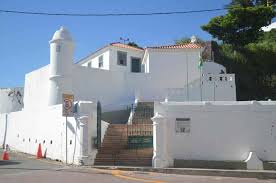
The Forte de São Diogo is also considered to be the work of D. Diogo Luís de Oliveira by the document of 1671. It is an irregular fortification
built at the foot of the hill where the original centre of the Old Town of Pereira Coutinho once stood, with its tranqueira (defensive wooden fence) and tower.

It is thought that, once the original defences had disappeared, this eminence was equipped with some battery or defence, because, situated at a higher elevation, it could be occupied by the enemy, neutralising the forts that were lower down.
The fire of the Forte de São Diogo, combined with that of the Forte de Santa Maria, would have been very effective in defending Porto da Barra.
Our tiny propugnacle is irregular in design, seeking to adapt its shape to the morphology of the terrain, with part of the curtain arched. The parapet was, and still is, barbette, retaining much of the original design.
The biggest change to the building’s structure must have been made to the main entrance.
The scholar Edgar Cerqueira Falcão photographed it before 1942, still with the internal access ramp, although with a staircase at the entrance gate.
All indications are that the greatest mutilation of the topography and the internal ramp took place when the Cirex, a recreational club for officers of the 6th Military Region, was built on the site.
The least altered form of the fortification was photographically documented by Benjamin Mulock in the mid-19th century.
According to old plans kept by the Army Military Archives, there was a path that passed near the fort and zigzagged up to the top, where the Church of Saint Anthony or Igreja de Santo Antônio is located.
Defences of Porto da Barra – Forts of Santa Maria and São Diogo – History of Brazil


