Este post também está disponível em:
![]() Português
Português ![]() English
English

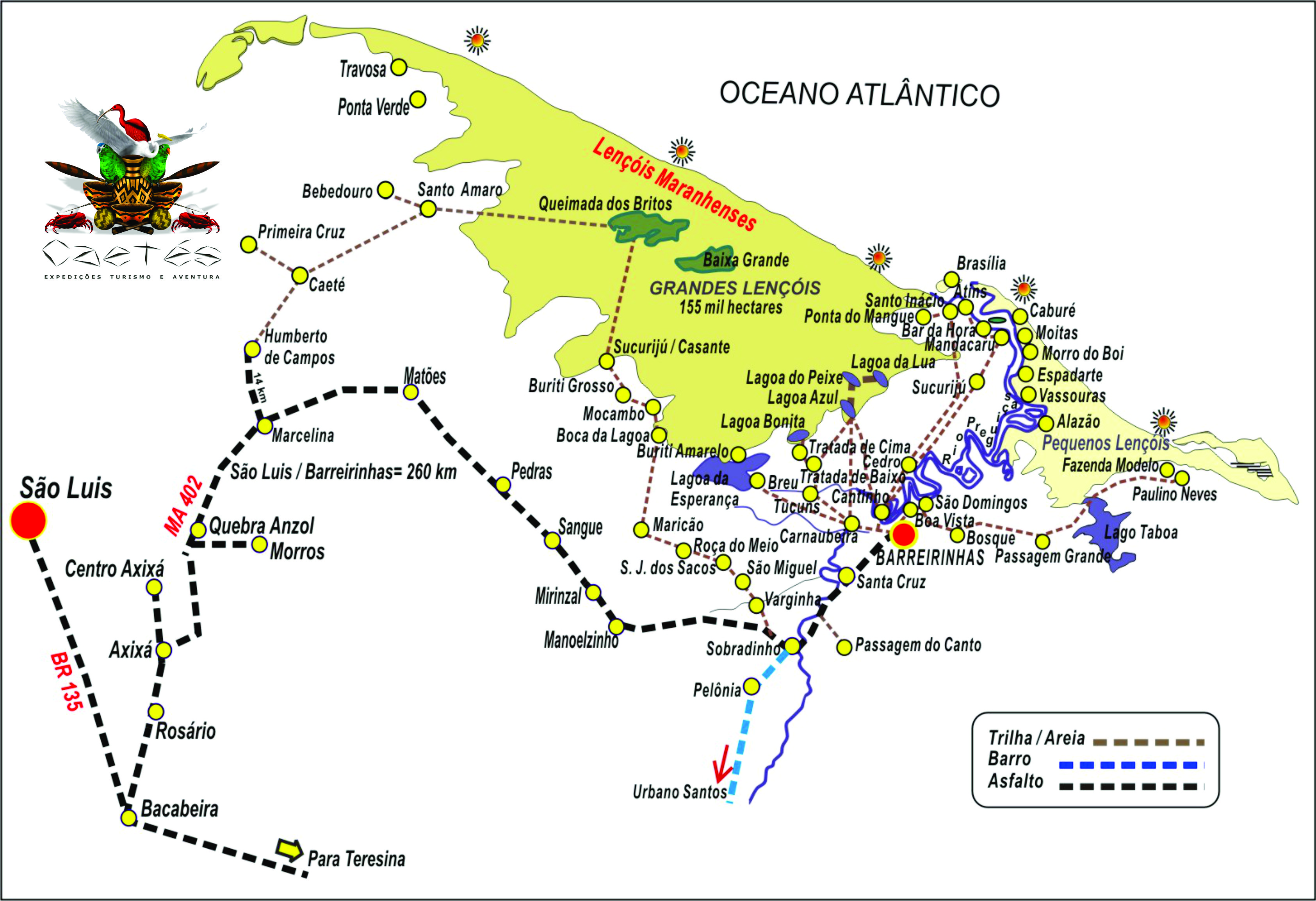
Lençóis Maranhenses National Park is located in the municipalities of Paulino Neves, Tutóia, Barreirinhas, Santo Amaro, Primeira Cruz and Humberto de Campos.
The Lençóis Maranhenses National Park covers 155,000 hectares of dunes, rivers, lagoons and mangroves.
There are two types of scenarios, depending on the time of year: during the drought, the park becomes a true desert bathed by the ocean; with the rains, the classic landscape of the place is formed, an incredible sequence of dunes and lagoons.
Exploring all this immensity of sand is a unique and tiring experience.
In the 1970s, a Petrobras team flew over Morrarias and coined a new name for it: Lençóis Maranhenses.
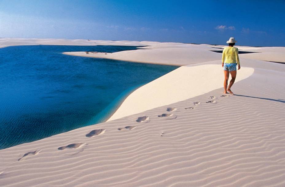
It’s perfect, anyone who sees the sand dunes has the feeling that they are looking at gigantic sheets, swayed by the wind under the sun.
It is the wind, in fact, that forms the dunes of almost 50 meters high, which extend for 100 kilometers of coastline and 50 km inland.

On the coast, the beaches are wide and extensive. Inland, the predominance is of “marraria”, that is, dunes dotted with lagoons formed by rainwater.
The dunes are spread over two deserts: the Grandes Lençóis Maranhenses, located west of the Preguiças River, and the Pequenos Lençóis, to the east.
Inaugurated in 1981, the Parque Nacional dos Lençóis Maranhenses occupies an area of 155,000 hectares, covering 270 kilometers of perimeter, in which are the municipalities of Paulino Neves, Tutóia, Barreirinhas, Santo Amaro, Primeira Cruz and Humberto de Campos.

Barreirinhas - Lençóis Maranhenses

Lençóis Maranhenses Guia

Lençóis Maranhenses Reportagem

Rota das Emoções Nordeste

Tutóia - Lençóis Maranhenses
Lençóis Maranhenses - Reportagem Completa13:09
Barreirinhas - Lençóis Maranhenses05:14
Caburé é um vilarejo de pescadores no Maranhão13:04
Passeio pelo Rio Preguiças
Santo Amaro do Maranhão10:00
Destinations and Tourist Spots of the Lençóis Maranhenses National Park
Barreirinhas is the most structured city around the preservation area, but there are also tours from Atins (east) and Santo Amaro do Maranhão (west).
Barreirinhas, 260 kilometers from São Luís, has the best infrastructure for tourists. It is home to the park’s headquarters.
The city is also a starting point for tours along the Preguiças River and is on the tourist route that includes the Parnaíba Delta, in Piauí, and Jericoacoara, in Ceará.

See the map Lençóis Maranhenses in Maranhão
After Barreirinhas, the most popular location is Santo Amaro do Maranhão, the setting for the movie Casa de areia, directed by Andrucha Waddington in 2005.
SMALL LENÇÓIS
The Small Lençois, which form a set of dunes outside the National Park, also offer beautiful scenery and freshwater lagoons for delicious bathing. Located on the banks of the Preguiças River, they also please with their diverse landscape.
During the tour, it will be possible to see mangroves, beaches and closed vegetation in the middle of the sand. To make Pequenos Lençóis even more interesting, try a speedboat tour, with stops in the villages of Mandacaru and Vassouras and also at Caburé Beach. It is also worth a quad bike tour between the dunes and the beach, leaving from Barreirinha and arriving at the sea.
BARREIRINHAS

Barreirinhas is a municipality of the state of Maranhão, in Brazil.
The municipality is known for being the “gateway” to the tourist region known as Lençóis Maranhenses, which consists of a vast area of high white sand dunes and lakes and lagoons, also known as the “Brazilian Desert”.
Barreirinhas in the Lençóis Maranhenses National Park, founded in 1871 on the banks of the Preguiças River, has always played the role of support city in the region.
Thanks to its location, it was a trading post for fishermen and farmers in the surroundings; today, it lives basically from tourism, concentrating hotels, inns, restaurants and tourist support services.
The city has a headquarters of the Chico Mendes Institute for Biodiversity Conservation where lectures are held on the ecosystems of the Lençóis Maranhenses National Park and the rules and care that must be followed to maintain them (av. Paulista, s/n, Boa Vista).

The great attraction of Barreirinhas is the Preguiças River, which cuts through it in a curve – a river of dark waters that is still clean, despite the developments that are beginning to spring up around it.
To explore the region, it is necessary to hire guides; of the more than ten agencies in the city, we highlight some with different profiles: Tropical Adventure offers personalized tours in vehicles with traction and air conditioning.
Eco-Dunas offers adventure sports, overflights, buoy-cross and tours in little publicized places within the park.
Rota das Trilhas offers more traditional tours.
The Tourist Office, located right at the entrance to the town, also provides directions and information.
Barreirinhas can be reached from São Luís by the MA-402, the Translitorânea, on a 265-kilometer route that takes about three hours.
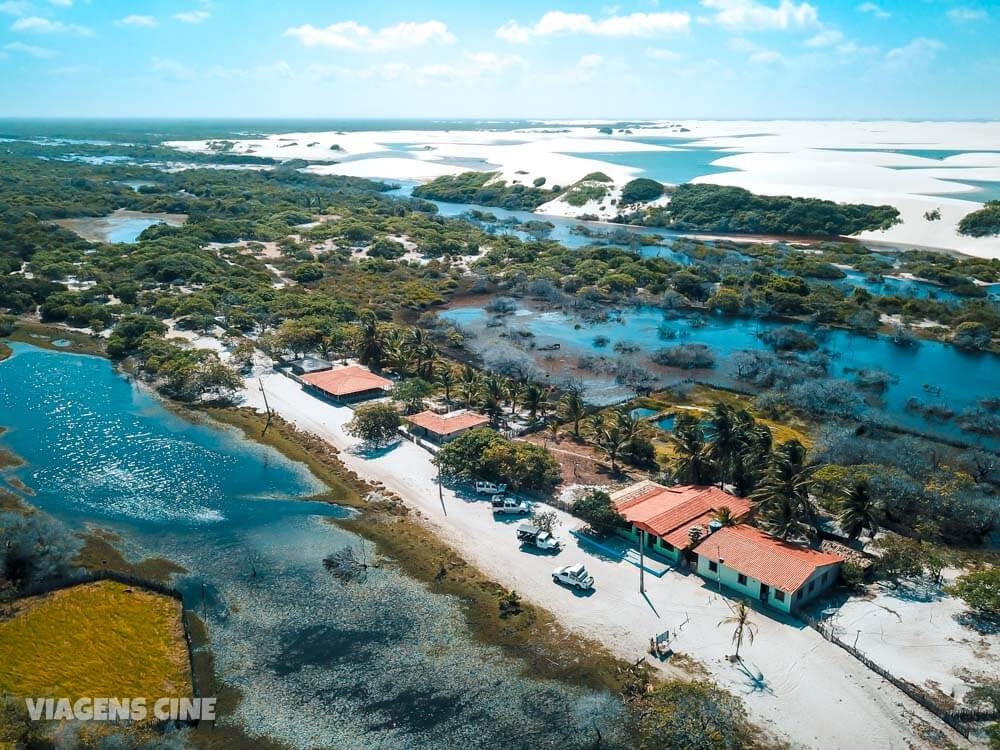
CABURÉ
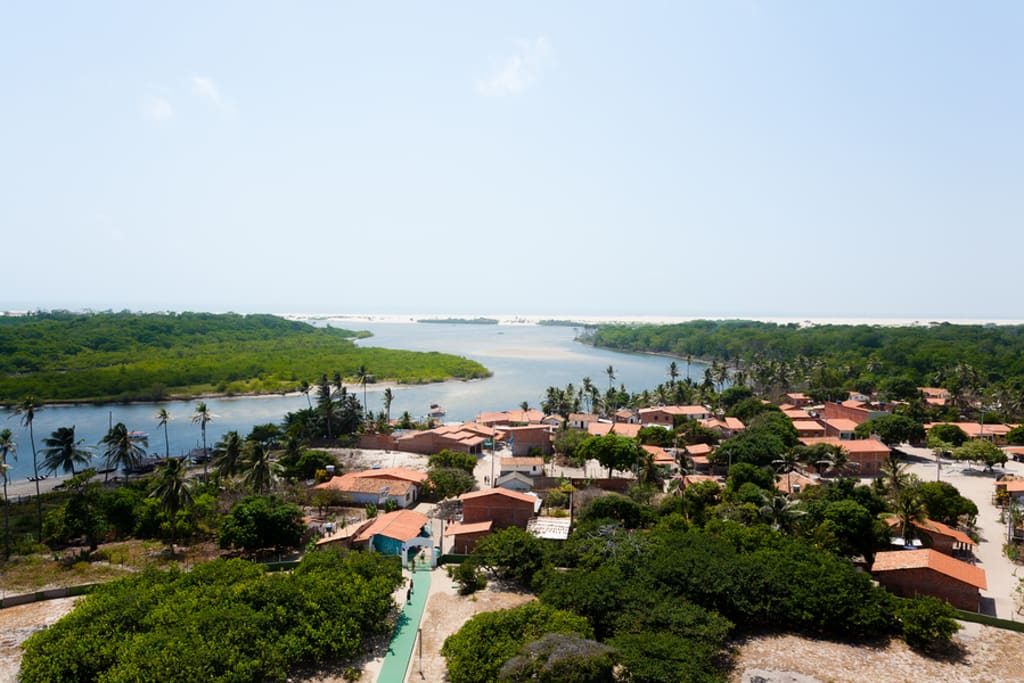
Caburé is a village of fishermen and its respective beach, located in the municipality of Barreirinhas, in the state of Maranhão, in Brazil. It is a usual stopover point for tourist excursions to the Lençóis Maranhenses National Park.
The beach of Caburé, which lies between the Preguiças River and the sea, is within the Lençóis Maranhenses National Park.
One of the most peculiar sensations is to get out of a dive from the sea, walk less than five minutes and get the salt water out of your body with a river bath.
WALKING THE PREGUIÇAS RIVER

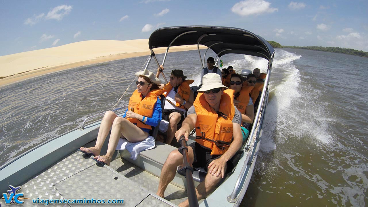
The crossing of the Preguiças River in the Lençóis Maranhenses National Park is done by speedboat or by voadeira – a fast boat with a motor on the stern, and is full of attractions.
The first are the 40-meter-high dunes that rise in Vassouras, a fishing village that is reached after 45 minutes of navigation.
There you can choose between a dip in the river or a walk along the beach of Pequenos Lençóis. The next stop is Espadarte, Morro do Boi and Moitas.
The next stop is the village of Mandacaru, where the Preguiças Lighthouse is located, with 160 steps. It is worth facing them, because from the top you can see the most beautiful view of the region.
Afterwards, lunch break in Caburé, near the mouth of the Preguiças River, a town without attractions, frequented only because of its restaurants.
LAGOONS
After crossing the Preguiças River, the program is to get on a jeep and take the direction of the lagoons of the Lençóis Maranhenses National Park.
As soon as you leave the ferry, the car follows a winding road, between lakes and streams, with flooded stretches.
In 40 minutes, you reach a point from which the journey must be made on foot.
Another five minutes and you reach the Preguiça lagoon, with its turquoise waters.
After another ten minutes’ walk, you reach the beautiful Blue Lagoon, which lives up to its name.

One of the most popular spots in the park, it is usually crowded – those who want more tranquility can walk another ten minutes to the Peixe lagoon, which, incidentally, is one of the only ones not to dry up in the summer (Azul simply disappears at the end of the year).
Surrounded by vegetation and with dark greenish waters, it precedes the famous Bonita lagoon, surrounded by dunes of up to 40 meters. To reach it, you have to take another winding road for about an hour.
DESCENT OF THE CARDOSA RIVER
The Cardosa River is about an hour and a half drive from the center of Barreirinhas.
Its crystal clear and calm waters invite you to go down by kayak or float-cross – a diving mask is indispensable to see the fish. The descent lasts an average of two hours.
PARK FLIGHT
For 30 minutes, a twin-engine airplane flies over the Lençóis Maranhenses National Park.
After taking off from Barreirinhas, it makes a panoramic view of the region, reaching the mouth of the Preguiças River in Atins. The aerial view of the large expanses of dunes and lagoons is unforgettable.
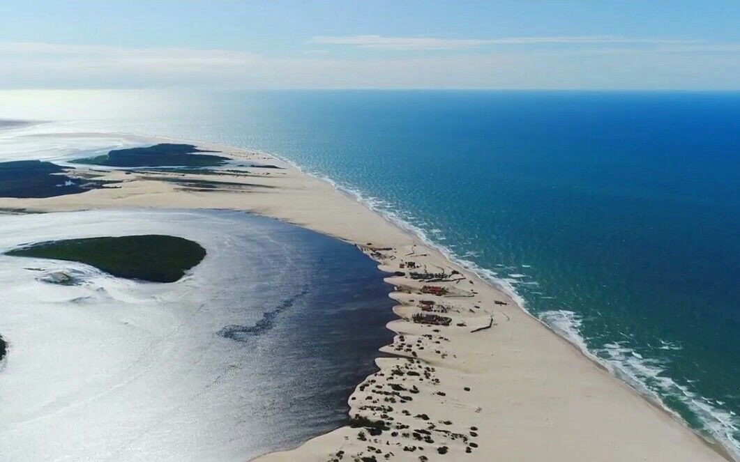
ATINS

In this village of Atins in the Lençóis Maranhenses National Park ends the trajectory of the Preguiças River, which then flows into the sea.
Atins, which can be reached with guides from agencies in Barreirinhas, marks the beginning of the so-called beach of the Great Lençóis, a region that ends 100 kilometers away, in Travosa, at the other end of the Lençóis Maranhenses National Park.
The small fishing village received electricity a few years ago and still lives from fishing.
There are no cars on the sandy streets, and a single public telephone ensures communication with the world.
For all this, Atins preserves a magical atmosphere, reinforced by its special geographical situation: located between the river and the sea, next to the dunes of the park and with a beach that, depending on the tide, is adorned by natural pools of salt water.
The village is surrounded by attractions such as the “poço das Pedras”, which opens up in the middle of the vast expanse of sand in a unique shade of turquoise blue, and the Mário lagoon, in whose dark waters white aquatic flowers float. On the outskirts of the lagoon, Mrs. Luzia serves incomparable prawns from her stall.
BURITI WOOD CRAFT
Buriti – a palm tree that borders much of the Preguiças River and the lakes of the region – is used for everything: starch is extracted from the pith; oil, juices, ice cream and other products are made from the pulp of the fruit: oil, juices, ice cream and sweets; the leaves cover dwellings, and from their shoots, called “eyes”, in addition to the palm heart, a fine thread is extracted, used in the making of bags, purses, hats and other handicrafts, which can be found in stores in the city, in stalls on the edge of the Bonita lagoon and on the ferries that cross the Preguiças River.
TUTÓIA
Tutóia is a Brazilian municipality in the state of Maranhão.
Although surrounded by natural beauty, the city itself, 400 kilometers from Barreirinhas, is unattractive: with a precarious structure of restaurants and inns, it is usually used as a bridge between the Lençóis Maranhenses and the Parnaíba River delta, in Piauí – which can be seen, in the distance, from the port.
The municipality is a support base for those visiting the Lençóis Maranhenses National Park and the Parnaíba River Delta.
In Tutóia it is possible to make several tours, such as visiting the 20 km of paradisiacal beaches, with calm sea and white sand dunes, among them Arpoador and Namorados, the Lagoons of Taboa, Jacaré, Areia and Lagoinha, the Islands Cajueiro, Coroatá, Melancieiro, Igoronhon, Grande, Pombas, José Correia, Caieira, Papagaio, forming the great Delta parnaibano, andalso to know the crafts in straw, leather, coconut, horn, line and shells that the region offers.
However, there are no speedboats available, only ferries that make the eight-hour crossing, every other day. By car, the connection between Tutóia and Parnaíba is via BR-402, with stretches in poor condition.
SANTO AMARO DO MARANHÃO
Santo Amaro do Maranhão, 232 kilometers from São Luís, is still a little frequented city.
One of the reasons for this is the difficulty of access.
Of the 96 kilometers that separate it from Barreirinhas, 35 are covered on sandy roads; in the winter months, with the heavy rains that fall in the region, the distance is only overcome in vehicles with four-wheel drive – which, even so, run the risk of getting bogged down.
With 10,000 inhabitants, the municipality bathed by the yellowish waters of the Alegre River is an alternative gateway for those who want to explore the Lençóis Maranhenses National Park.
Unlike Barreirinhas, located an hour from the dunes, Santo Amaro is nestled in them.
You can reach this town by the MA-402 to the village of Sangue; the best option, in view of the precariousness of the road, is to go by chartered jeep, with a guide, from Barreirinhas.
LAGO DE SANTO AMARO
Located on the banks of the Alegre River, Santo Amaro is surrounded by lakes, lagoons and rivers that cut through the immensity of white sands.
One of its attractions is the Santo Amaro Lake, where part of the Alegre flows; full of fish, it provides the livelihood of most residents. To visit it, you need to rent a boat in the village, which will travel the shallow waters of the river, passing through small communities.
The town’s postcard is the Gaivota lagoon, 6 kilometers from the center – which is an hour’s walk or 30 minutes in a four-wheel drive vehicle.
Spilling into the middle of very white dunes, the stunning turquoise lagoon is full all year round, especially in winter.
Shallow at the edge, it reaches 2.5 meters deep – an irresistible invitation to bathe.
If you keep going up and down the dunes, you’ll reach Cajueiro in 20 minutes: a small house surrounded by leafy mango trees and – of course – cashew trees, some of them centenary; next to it, a lagoon with dark waters, from where the owner of the house takes his daily meal.
An almost unreal setting, with a simple beauty. On the outskirts of Santo Amaro is the well known as Barreira das Pacas, with access not regulated by Ibama.
QUEIMADA DOS BRITOS
One hundred residents, 5,000 goats – goat breeding is among the main economic activities of the place -, beautiful dunes and lagoons.
This is Queimada dos Britos, a village located within the Lençóis Maranhenses National Park.
A green area embedded in the sand, it resembles an oasis, with very simple houses covered in straw and still without electricity.
The village is reached after two hours by jeep with traction or eight hours of difficult walking through the sand.
Near Queimada dos Britos is Baixa Grande, another lush green area in the middle of the sand.
This region is benefited by the presence of the Negro River, whose course cuts from north to south throughout the National Park. At its source is the Esperança lagoon, another beautiful attraction of the park.
THE SIMPLE PLEASURES IN THE VASTNESS OF THE LENCOIS
It is difficult to express in words the size and grandeur of the Lençóis Maranhenses.
To understand them you have to be there – and let your soul be as light as the wind, assimilating the incessant movement of the beach sands that enter the continent to form the gigantic dunes.
In the unusual landscape of Lençóis Maranhenses, it is possible to enjoy rare pleasures: watching the sunset from the river or the sea, admiring flocks of guarás, walking for hours on an immense and deserted beach, until you find a lagoon of unimaginable shade of blue in the middle of the white vastness – a surprising gift from nature.
Above all, there you can rediscover simple and lost pleasures: running, playing, swimming, sailing in a canoe with sails improvised with plastic bags, breathing deeply, listening to the sound of silence.
Then, when the generators are switched off – at 10 p.m. – you can lie under the pitch-black sky, streaked with shooting stars.
The dunes are divided into Pequenos and Grandes Lençóis, cut by the slow and enchanting Preguiças River, on whose banks stand tiny and rustic villages – Vassouras, Caburé, Mandacaru, places without any infrastructure, very different from the mass tourist destinations.
Barreirinhas, the base town for tours in the region, is now beginning to organize itself; in high season, its modest streets are taken over by cars and jeeps that leave and arrive from the dunes taking visitors mainly to the Blue and Fish lagoons, which are easier to access.
Those willing to walk a little further will be rewarded with other, more beautiful and empty, in a feeling of permanent discovery: when climbing a dune, you never know what you will find on the other side; it may come a long bran co space, or another dune, or a new lake of transparent and warm waters.
The great paradox is that in this scene of permanent movement, where you watch the eternal dance of wind and sand, there is a side of permanence – it has been the same for hundreds of years, and there is no sign to remind you that we are in the 21st century.
A play of illusions with time and space.
From Barreirinhas, you can travel along the Preguiças River passing through its villages. The watercourse winds its way through sand hills and flooded mangroves.
Near the mouth is Caburé, a village situated on a sandy peninsula. On one side is the river, on the other the sea. In between, there are a few rustic buildings, some simple inns.
And the traveler, between river and sea, between fresh and salt water, receiving the wind in the face. From there, you can clearly see that the sheets are not homogeneous.
To the east, the dunes are yellowish, the lagoons darker.
From Caburé you can take a boat to walk around the small Atins – from where, after walking, you reach the deep Poço das Pedras, with emerald green water. Ask, in the middle of the tours, for Luzia’s shrimp – and the program will be complete and unforgettable.
In a globalized world, where even the most remote corners have sophisticated hotels with impeccable service, the Lençóis Maranhenses appear as a strange exception, a place apart.
But with their rustic and unspoiled beauty, the simplicity of their accommodations and the authenticity of their residents, they have established themselves as one of the most irresistible travel destinations in Brazil – for those who know how to enjoy them, they are pure luxury.
See when to go to Lençóis Maranhenses
Lençóis Maranhenses Travel and Tourism Guide
Barreirinhas Tourism and Travel Guide


