Este post também está disponível em:
![]() Português
Português ![]() English
English

Pico das Almas, Pico do Itobira and Pico do Barbado is a special itinerary for lovers of trekking.
Pico das Almas is the dividing line for the municipalities of Livramento de Nossa Senhora and Rio de Contas.
With 1,958 meters, it is the 3rd highest point in the Northeast Region of Brazil, next to Pico do Itobira and Pico do Barbado, these with 1,970 and 2,033 meters respectively.
At the foot of the town of Rio das Contas in Chapada Diamantina, the mountain rises by a large wall to more than a thousand meters high, creating from there on a gigantic complex of mountains, valleys, rocky fields, caves, canyons and waterfalls to make envy of any other chapada.
Rio de Contas is the oldest city of Chapada Diamantina, possessing one of the three most important and beautiful colonial architectural ensembles of Bahia, it is a true city-museum.
It houses almost 300 historic buildings listed by the National Historical and Artistic Heritage Institute (IPHAN), including the Mother Church, with its gold-plated altar, and the São Carlos Theater, the first in the interior of Bahia.
Its houses and cobbled streets are very well preserved and give off a delightful atmosphere of warmth and tranquillity. Opulent city in the times of gold, today stands out again with ecological tourism.
With several natural attractions around Rio das Contas in the Chapada Diamantina, the municipality holds the highest peaks in the Northeast: Pico do Barbado, Pico do Itobira and Pico das Almas.
Map of the Trails and Tourist Spots of Chapada Diamantina
The highest is Pico do Barbado, which is 2,033 meters high and lies between Rio de Contas, Abaíra and Piatã – the latter, by the way, a city famous for the mountainous climate with which it celebrates its São João.

Built in the 19th century in Rio de Contas, but it was not finished and is a landmark of the decline of gold extraction.
The other two are Pico do Itobira, at 1,970 meters, and Pico das Almas, at 1,958 meters, both in Rio de Contas. All three can be reached on hikes that lead to incredible views of the entire southern Chapada.
But it is Pico das Almas that has become the apple of Rio de Contas’ eye.
To reach its summit, it is a three-hour walk amidst quartzite formations that rise from the earth, orchids, bromeliads and unique vegetation.
In 1974, Pico das Almas attracted a team from the London Botanic Gardens, Kew Gardens, which surveyed 1,200 plant species, 100 of them endemic – making Pico das Almas one of the most biodiverse places in South America (proportional to its size, of course).
A wealth that has already been compared to that of the Amazon rainforest. The British, it seems, already knew what it took us 30 years to discover: that there are many more treasures buried in the golden heart of Bahia than we could ever imagine.

and on the left side beginning of the trail
And not all of them are gems.
After this long overview of the city of Rio das Contas, you can already tell that this text is another article in the series of trekking in Chapada Diamantina. That’s right!
This itinerary is special for lovers of mountaineering and great crossings. Let’s talk about the crossing that aims to climb the three highest peaks in the Northeast: Pico das Almas, Pico do Itobira and Pico do Barbado.
This route is unique, it is approximately 43km with a degree of difficulty from moderate to difficult, where you will face high altitudes, low temperatures and still know small villages and agricultural communities embedded in the mountains and little known valleys of the region.
Trekking to Pico das Almas, Pico Itobira and Pico do Barbado
1st day – Rio de Contas, Pico das Almas, Vale do Queiroz
Departure from Rio de Contas in the morning, towards Fazenda Silvana, where you will start the trail to Vale do Queiroz, camping site.

It was one of the most feared Bahian prisons at the time of slavery.
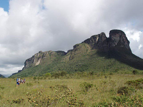
From there follow the trail for about 1h20 until you reach the Portal das Almas, a landscape unlike anything that Chapada Diamantina offers, with pointed stones of various sizes everywhere.
In the final stretch there is a ‘hike’ through the steepest part of the massif that leads to the summit, it is approximately 3 hours of ascent until reaching the 1,958 meters of altitude of Pico das Almas, with a beautiful panoramic view of the Chapada Sul. The return descent by the same trail and return to the base camp, in the Queiroz Valley.
Passage through the Queiróz Valley
An ecological sanctuary, a large highland at about 1,600 meters altitude, surrounded by mountains on all sides, where you can take a refreshing bath (in summer) in the stream that cuts through the valley, the place also has several types of microlícias and evergreens.
Passage near the source of the Brumado River
The largest river in the city of Rio de Contas is born on the way to Pico das Almas, at about 1,700 meters of altitude, its waters start sprouting from the rocks.
Passing through remnants of Atlantic forest
The site has a small area of Atlantic forest where there are trees about 20 meters high.
Passage through the Portal of Souls<nbsp;
A rock formation in the shape of a portal, also known as the window of heaven.
Panoramic 360° view
From the top, visitors can see the neighboring city of Livramento de Nossa Senhora, the Campos Gerais of the city of Rio de Contas, the Portuguese community of Mato Grosso, Pico do Itobira (1,700), part of Pico do Barbado (2,033m), and a vast mountain range that is a continuation of the Serra do Espinhaço mountain range that begins in the state of Minas Gerais.
2nd day – Vale do Queiroz, Coronel bridge, Caiambola farm, Itobira Peak
Return by the trail to Silvana farm, where there will be a support car, continue by car, with a stop to take a river bath at Coronel bridge. Continue towards Caiambola, where the trail begins.

Going around a large capon of forest at the foot of Pico do Itobira, the trail follows a general, full of flowers and grasses. After about 1h30 of walking, you reach the base of Pico do Itobira, the trail goes upwards, with a beautiful view of the desert fields of Chapada Sul.
Continue for about 1h of ascent, where you will reach the 1,980 meters of altitude of the second highest mountain in the Brazilian Northeast. There are two options afterwards on this itinerary, sleeping at the summit (if the forecast is good) or sleeping at the base, near the water.
3rd day – Pico do Itobira, Lapa da Mutuca,Vale do Guarda Mor
Descend from the summit and head towards Lapa da Mutuca, from there begins one of the most difficult and contemplative sections of the trail, passing through Lapa da Mutuca, and continuing to Guarda Mor, where the overnight stay will be.
4th day – Catolés, Pico do Barbado, Catolés, Piatã
In the morning, climb a trail through the cliffs of Serra do Barbado about 2h to a place called Forquilha da Serra, a kind of step between Pedra do Elefante and Pico do Barbado.
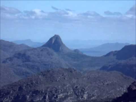
From this point continue for about 20 minutes to Pico do Barbado, the summit of the highest mountain in northeastern Brazil, with 2,033 meters of altitude.
With a 360º view of the Itobira and Almas Peaks, the Serra da Tromba and Três Picos in Piatã, and the Sincorá mountain range on the horizon, you can see the Pai Inácio and Morrão hills. After contemplation and photos at the summit, the trail descends about 2 hours to the village of Catolés de Cima. Where a car will take you to the city of Piatã.
The top of the Northeast with 2,033 meters is Pico do Barbado
Pico do Barbado in Chapada Diamantina is the highest peak in Northeastern Brazil and Bahia with about 2,033 meters, being located on the border between the municipalities of Rio do Pires and Abaíra, in Bahia.
It is a geological formation of rare beauty and is in an environmental protection area due to its exuberant botanical richness. It is an integral part of the Chapada Diamantina.
Pico do Barbado is located in the village of Catolés de Cima in the municipality of Abaíra.
Pico do Barbado is the highest point of the Northeast with 2,033 meters high, it is a geological formation of rare beauty and is in an environmental protection area due to its exuberant botanical richness.
To get to Pico do Barbado, leaving Abaíra by car or motorcycle towards the district of Catolés and from there heading to the village of Catolés de Cima.
The road is dirt with slopes paved with stones. From the top of the peak you can see other peaks, such as Itobira and also Pico das Almas in the neighboring municipality of Rio de Contas, and Serra da Tromba, in Abaíra and Piatã.
There is a trail to climb the peak from Catolés. You can drive up to the last house on the street, from where you can climb to the top in two and a half hours. From the top you can see several peaks such as Itaobira and Pico das Almas further away and mountains such as the beautiful Serra da Tromba. There is a topographic map of the Barbado region for sale in Lençóis and Mucugê.
Trekking to Pico das Almas, Pico do Barbado and Pico do Itobira
Chapada Diamantina Tourism and Travel Guide


