Este post também está disponível em:
Português
English
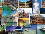
The State of Ceará has one of the most beautiful tourist spots in Brazil, with a rich culture associated with beautiful landscapes, among beaches, mountains and waterfalls.
Ceará has one of the largest and most important coastal strips in the country from a tourist point of view, which extends for 573 km, in which mangroves and restingas, typical coastal vegetation, predominate, as well as areas without vegetation covered by dunes.
Even with very low altitudes, rainfall and humidity are higher than in the Sertaneja Depression.
Average temperatures range from 22 °C to 32 °C.
The coastal plain has a diverse geography, which means that the state has many beaches with coconut groves, dunes, barriers (also called cliffs) – sedimentary walls that follow the coastline and, in some stretches, have colorful tones – and mangrove wetlands, in which there is great biodiversity.
It is no coincidence that the symbol of Ceará is a raft. The state has 573 kilometers of beaches, many of which still preserve the coastal culture of artisanal fishing.
Punctuated by dunes, lagoons and mangroves and sunny at almost every time of the year, the coast of Ceará is one of the most sought-after tourist destinations in the country.
Europeans began to arrive in the lands of present-day Ceará shortly before the landing of Alvares Cabral in Bahia: on February 2, 1500, the Spanish navigator Vicente Pinzón would have reached the coast of Mucuripe, in the region of present-day Fortaleza.
The story of which Ceará is most proud, however, is that of the jangadeiro Francisco José do Nascimento, nicknamed the Dragon of the Sea.
Born in Aracati, on the east coast, he managed to prevent the landing of slaves at the port of Mucuripe, in one of the most important chapters of the abolitionist struggle in the country.
Videos about Ubajara, Sítio do Bosco in Tianguá, Quixadá, Jericoacoara, Canoa Quebrada, Morro Branco, Praia do Futuro in Fortaleza, Juazeiro do Norte and Canindé.

Tourist Spots of Fortaleza and Ceará
Ceará, after all, was the first Brazilian province to free its slaves, in 1884, four years before the signing of the Golden Law. A good way to enter the landscapes and cultural universe of Ceará is to visit its capital.
A metropolis with a lively cultural life, from here you can go to the east coast, called the Costa do Sol Nascente, or to the west, the Costa do Sol Poente.
You can also head to the sertão, if the goal is to get to know the faith of the people: Juazeiro do Norte is the epicenter of devotion to Father Cícero, a historical character taken as a saint throughout the Northeast.
Ceará also offers visitors the friendly Sobral, its second largest city, founded in 1841 and today the guardian of a rich architectural complex listed as a national historical heritage site.
Unlike the rest of the state, where the heat reigns, milder climates can be enjoyed in small Ubajara; located in a mountainous region, at 847 meters of altitude and between areas of Atlantic forest, the city is the gateway to the Ubajara National Park, which protects a spectacular set of limestone caves.
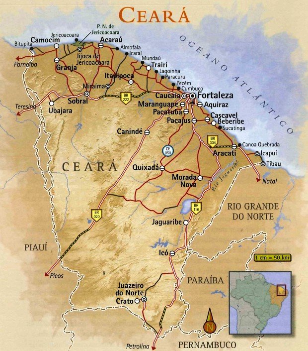
The most famous beaches in Ceará are Jericoacoara Beach, Canoa Quebrada Beach and Porto das Dunas Beach, which have achieved international fame.
Regionally, other outstanding beaches are Praia das Fontes, Morro Branco, Icaraí, Presídio, Baleia, Flecheiras, Cumbuco, Ponta Grossa, Lagoinha and Barra do Cauipe.
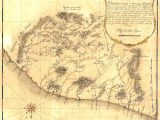
The coast of Ceará is crossed by two highways, called the Costa do Sol Nascente and the Costa do Sol Poente, which, from Fortaleza, head towards the east and west coasts, respectively.
- The historical and cultural itineraries of the city of Fortaleza.
- The stripped Canoa Quebrada, the main attraction of the Costa do Sol Nascente.
- Discover the beautiful beaches of Ceará, as well as Morro Branco and Tatajuba.
- The beach of Jericoacoara, a cosmopolitan destination that has not lost the simplicity that predominates on the Costa do Sol Poente.
- Juazeiro do Norte, in the Ceará hinterland, where the largest pilgrimages in the Northeast are held.
- The rustic architecture circuit of the city of Sobral and the limestone caves of the Ubajara National Park.
- The beauties and charms of the Chapada do Araripe.
- Religious tourism
- Kitesurfing in Cumbuco on the west coast of Ceará.
- History of Lavras da Mangabeira and Salgado River Canyon in Ceará
- The 18 best beaches on the coast of Fortaleza and Ceará
- Religious tourism in Juazeiro do Norte and the Cariri region
- Guaramiranga is known as the Switzerland of Ceará
- Three-day tourist itinerary in the Cariri region of Ceará
- Best beaches on the coast of Ceará
- Icapuí is known for its cliffs and lobster in the far east of Ceará
- Tatajuba beach is one of the most charming in Ceará
- Tatajuba is a perfect place for kitesurfing
- Serra de Ibiapaba nature, flavors and extreme sports
- Tourist Guide to Ubajara National Park in Ceará
- Tourist Sites, Architecture and History of Icó in Ceará
- Caetanos de Cima is one of the most beautiful beaches in Ceará
- Jericoacoara is a spectacle of nature and has plenty of attractions
- Quixadá is the best place in Latin America for paragliding and hang-gliding
- Cariri is a privileged place with the beauties of Chapada do Araripe
- The green landscape of the Baturité Massif is one of the most sought after destinations
- Tourist and Travel Guide of Aracati CE
- Aquiraz CE is home to Beach Park, huge dunes and deserted beaches
- Canoa Quebrada in Ceará brings together sport, fun and leisure
- Ceará is paradise for tourism and extreme sports
- The Jaguaribe River is the biggest attraction of Fortim in Ceará
- Beach Park on Porto das Dunas beach has put Aquiraz on the tourist trail
- Costa dos Ventos attracts tourists interested in the sun and good winds
- Natural beauty of Paracuru Beach attracts families and sportsmen
- Rota das Falésias in Ceará offers unforgettable tours
- Route of Emotions promotes adrenaline and intimate contact with nature
- Juazeiro do Norte in the Sertão do Ceará is the land of Padre Cícero
- Serras do Ceará are formed by mountains with altitudes up to a thousand meters
- Main cities and beaches of the West Coast of Ceará
- East Coast of Ceará maintains its authenticity even on the busiest beaches
- Fortaleza is called the “land of the sun”, the wind, the rafts and the endless beaches
- Ceará has a wonderful landscape of beaches with dunes and cliffs
WHEN TO GO TO CEARÁ
- From July to December, to enjoy the sunny coastline. Between January and March the beaches are crowded and prices increase.
- Between December and May, the rainy and hot season, to enjoy the fullest lagoons, the dunes and the beaches.
- From January to June, when the municipality of Sobral, with an average temperature of 30°C, gains milder air.
- On the three great pilgrimages in honor of Padre Cícero: on September 15; from October 30 to November 2; and from January 30 to February 2.
CLIMATE IN CEARÁ
Ceará is characterized by the presence of two types of climate: humid tropical and semi-arid. Located between 2ºS and 7ºS, the state is very close to the Equator, suffering the direct action of the trade winds, which intensify the wind regime in the region.
In most of its territory, the semi-arid climate predominates, thus registering a large number of periodic droughts. The humid and sub-humid portion of the state is concentrated in part of the coast and in areas with higher topographic elevation.
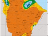
The wetlands of Ceará correspond to regions of higher altimetry, as well as portions of the coast of Ceará. The rainy season occurs between January and July with a pre-rainy season in December.
In these regions, annual rainfall rates exceed 900 mm, ensuring local humidity for about six months.
Two meteorological systems predominate for the occurrence of rainfall in the state: the Intertropical Convergence Zone (ITCZ), which causes humidity in the region during the maximum of its oscillation in the Southern Hemisphere, and the Atlantic Equatorial Mass, which carries the humid trade winds. In the upper portions of the state, the orography is responsible for the humidity in the different residual massifs found in the middle of the Sertaneja Depression.
The semi-arid climate, marked by water scarcity throughout the year, predominates in almost the entire state, especially in its central portion. About 92% of the territory of Ceará registers this climatic type, which affects the foothills of the mountains and the region of the Sertaneja Depression with more intensity.
The annual temperature range in the region is low, in contrast to the evapotranspiration rates.
While the rainy season lasts three to five months (usually from February to April), drought can extend for up to nine months in the state.
Under normal rainfall conditions, rainfall rates are between 500 and 800 mm, which leads to a water deficit for agriculture and the population living in the semi-arid region.
Ceará Tourism and Travel Guide


