Este post também está disponível em:
![]() Português
Português ![]() English
English
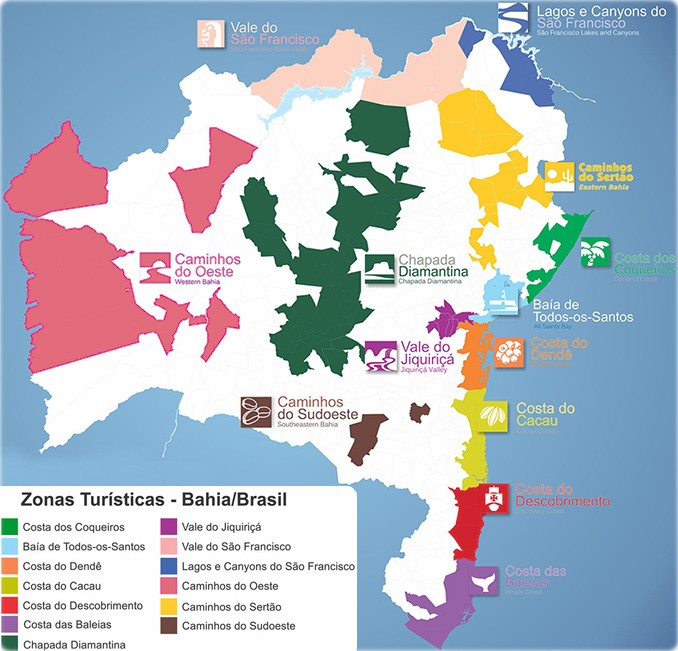
Bahia is divided into 13 tourist regions: Baía de Todos os Santos, Caminhos do Jiquiriçá, Caminhos do Sudoeste, Caminhos do Sertão, Caminhos do Oeste, Costa dos Coqueiros, Costa do Cacau, Costa do Descobrimento, Costa das Baleias, Chapada Diamantina, Lagos do São Francisco and Caminhos do Oeste and Salvador.
Bahia’s Main Tourist Regions
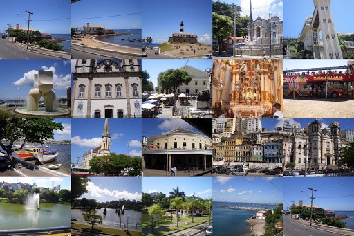
1. Salvador de Bahia
Salvador (founded as São Salvador da Bahia de Todos os Santos) is a Brazilian city, capital of the state of Bahia and the first capital of Brazil.
The inhabitants are called soteropolitans, a gentile created from the translation of the city’s name into Greek: Soterópolis, i.e. “city of Salvador”, composed of Σωτήρ (“savior”) and πόλις (“city”).
Regiões Turísticas da Bahia

2. Baia de Todos os Santos
It is served by Salvador International Airport, which is authorized to operate aircraft of any size, and by an airport for single-engine aircraft in Itaparica.
In addition to Aratuípe, Cachoeira, Itaparica, Jaguaripe, Santo Amaro…
It has a seaport for passengers, at Salvador, and terminals for ferry connections between Salvador and Itaparica. It also has regular air, road and sea transportation services.
The multiplicity of the Bahian capital, the Recôncavo and the region captivates visitors from all over, and can be seen and felt in the syncretism religious, in its musicality, folklore and history, in which the strength of the Indian natives and the Portuguese colonizer harmonizes with the African heritage of the city with the largest population of black origin outside Africa.
View the map of Baía de Todos os Santos
3. Paths of the Jiquiriçá – Caminhos do Jiquiriçá
Amargosa, Cruz das Almas, Milagres…
Waterfalls, rivers, hills, exuberant flora and fauna have aroused the interest of countless visitors, from those seeking contact with nature to those who prefer extreme sports.
4. Paths of the Southwest – Caminhos do Sudoeste
Iguaí and Vitória da Conquista
The southwest region of Bahia is located in a semi-arid region and has shown a great vocation for business and cultural tourism.
The city of Iguaí is one of the municipalities with the greatest tourist potential, as it has natural landscapes with trails, waterfalls, hundreds of river springs and coffee plantations that together form mosaics of rare beauty.
5. Paths of the Sertão – Caminhos do Sertão
Canudos, Cipó, Ribeira do Pombal, Uauá…
Marked by its peculiar climate and vegetation, the sertão has destinations for historical, cultural and religious tourism.
Because it was the scene of important historical events, some towns in this region, such as Canudos, have a great cultural heritage. The Canudos State Park, for example, was the scene of several battles during the War of the Same Name.
6. Coconut Coast – Costa dos Coqueiros
Conde, Entre Rios, Esplanada…
North of Salvador is the Costa dos Coqueiros, 193 kilometers of beaches surrounded by rivers and dunes, which are home to unique environmental riches along the Estrada do Coco and the Linha Verde – the country’s first ecological highway.
Formed by municipalities located to the north of the Bahian capital (Camaçari, Conde, Entre Rios, Esplanada, Jandaíra, Lauro de Freitas and Mata de São João), the Coconut Coast is one of the most popular tourist areas in the state, home to destinations such as Praia do Forte, Costa do Sauípe (the largest group of resorts in South America), Imbassaí and Mangue Seco.
View the Costa dos Coqueiros map
7. Cocoa Coast – Cocoa Coast
Canavieiras, Ilhéus, Itabuna, Itacaré, Pau Brasil, Santa Luzia…
Along the 180 km of road between Itacaré and Canavieiras, passing through Ilhéus and Una, you can see magnificent scenery where the forests overlook white sandy beaches, lagoons, mangroves and nature reserves.
There are six conservation units, including the Reserva Biológica de Una, a sanctuary for the endangered golden-faced lion tamarin.
Comprising the municipalities of Canavieiras, Ilhéus, Itacaré, Santa Luzia, Una and Uruçuca, this region became world famous through the stories of love and adventure told by Jorge Amado.
8. Costa do Dendê
Cairu, Camamu, Ituberá, Maraú, Valença…
Beaches with warm waters, rivers, forests, waterfalls and still primitive trails. Along the 115 km of coastline lies an archipelago of 26 islands.
The largest of these is Tinharé Island, home to Morro de São Paulo, one of the most popular places for visitors.
It offers a diversity of natural scenery, including more than 115 km of beaches, three large islands and Camamu Bay.
The Dendê Coast is made up of the municipalities of Boipeba, Cairú, Camamu, Igrapiúna, Ituberá, Maraú, Nilo Peçanha, Taperoá and Valença, and as its name suggests, it is where palm oil is produced, a basic ingredient in Bahian cuisine.
It is in this Tourist Zone that the Una River archipelago is located.
In this region of jagged coastline dominated by archipelagos, to the south of the Recôncavo Baiano, lies the town of Morro de São Paulo, one of Bahia’s best-known and most sought-after tourist spots, located on the Tinharé Island.
View the map of the Costa do Dendê
9. Costa do Descobrimento- Discovery Coast
Eunápolis, Itabela, Porto Seguro.…
At the foot of Monte Pascoal, a sequence of beaches, cliffs, coral reefs, mangroves, forests and rivers stretches for 150 km. The region has been declared a World Natural Heritage Site by Unesco.
Considered the cradle of Brazilian history and civilization, the Costa do Descobrimento-formed by the municipalities of Belmonte, Porto Seguro and Santa Cruz Cabrália – offers an unparalleled range of historical and natural attractions.
View the Costa do Descobrimento map
10. Paths of the West – Caminhos do Oeste
Located on the left bank of the São Francisco River, this region is made up of the municipalities of Barreiras, Bom Jesus da Lapa, Correntina, Santana, Santa Rita de Cássia, Santa Maria da Vitória, São Félix do Coribe and São Desidério.
With its flat terrain and typical cerrado vegetation, the west of Bahia is a rich region due to the success of agribusiness: it is the main grain producer in the north and northeast of Brazil.
Western Bahia preserves most of its natural beauty practically intact – tributaries in the direction of the São Francisco River form canyons, caves and valleys where you can contemplate the beauty and practise water sports.
Considered attractive for its exotic landscapes, this tourist area has seen significant economic growth, driven by significant advances in its agro-industrial sector, notably grain production.
View the map of the western roads
11. Costa das Baleias – Whale Coast
Alcobaça, Caravelas, Itamaraju, Mucuri…
The coastline is marked by the presence of whales, especially humpbacks, and by cliffs of up to 25 meters (Abrolhos National Marine Park). Made up of five islands, the Archipelago of Abrolhos brings together biodiversity in a sea of shallow, crystalline waters, reefs and underwater caves.
Comprising the municipalities of Alcobaça, Caravelas, Mucuri, Nova Viçosa and Prado, the main tourist attraction of the Costa das Baleias is the annual migration of humpback whales to the coast in the far south of the state, which can be seen in the Abrolhos National Marine Park.
View the map of the Costa das Baleias
12. Chapada Diamantina
Andaraí, Ibicoara, Mucugê, Palmeiras…
Trails blazed by prospectors reveal the region of springs in the Paraguaçu Basin, which is home to countless rivers, waterfalls and crystal-clear wells. This is where the Parque Nacional da Chapada Diamantina is located, which is home to a biodiversity that is still partially unknown.
Divided into four circuits – Chapada Norte, Circuito do Ouro, Circuito do Diamante and Chapada Velha – the Chapada Diamantina is one of the most extensive tourist areas in Bahia. Located in the central region of Bahia, the municipalities included in these circuits have their history linked to important moments in national life, such as the exploitation of mining in the 17th, 18th and 19th centuries.
View the Chapada Diamantina map
13. Valleys, canyons and lakes of the São Francisco
Casa Nova, Curaçá, Juazeiro, Remanso, Sobradinho…
In the region, fine wines add a special flavor to the countryside cuisine.
This is already considered the second largest wine production center in Brazil.
It is part of the wine tourism itinerary to stroll through the vineyards, learn how to pick grapes and get to know their potential, visit the wooden barrel cellar and get to know how wine is made.
One of the routes is the Vapor do Vinho – Juazeiro – Sobradinho – Casa Nova – this route includes the Lock, which allows boats to overcome the gap created by the dam, thus guaranteeing the continuity of the traditional navigation between the stretch of the São Francisco River.
Characterized by the influence of the São Francisco River, this tourist area is made up of the municipalities of Abaré, Casa Nova, Curaçá, Glória, Juazeiro, Paulo Afonso, Remanso, Rodelas, Santa Brígida and Sobradinho, whose main attractions are fishing and water sports in general.
View the Lagos de São Francisco map
Bahia’s Main Tourist Regions
Bahia.ws is the largest travel and tourism guide for Bahia and Salvador.


